Al-Rachidia
Al-Rachidia (also spelled Errachidia) is a town located in east-central Morocco. Situated on the Saharan side of the Atlas Mountains near the border with…
What is Al-Rachidia?
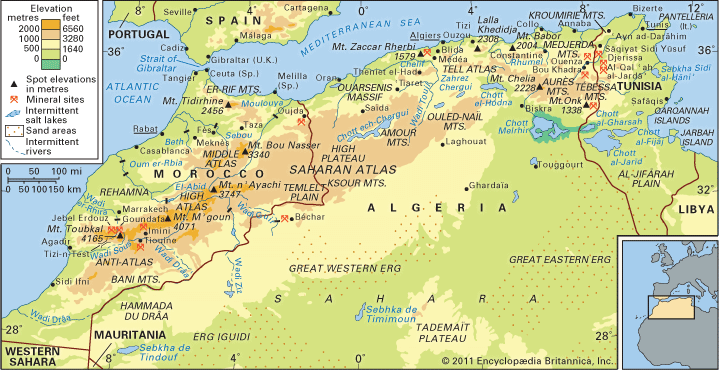
Al-Rachidia (also spelled Errachidia) is a town located in east-central Morocco. Situated on the Saharan side of the Atlas Mountains near the border with Algeria, the town serves as a road junction along the banks of the Wadi Ziz.1
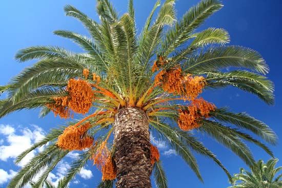
Historically, the town was occupied by the French from 1916 until the mid-1950s. Today, it functions as an irrigated oasis known for its date, olive, and fig trees, and it hosts an agricultural experimental station. While the surrounding region is arid and historically reliant on subsistence farming and nomadic herding, the construction of a dam directly above the town in 1972 significantly impacted the local economy. The area now supports the cultivation of citrus fruits, and the region is also known for lead and zinc mining.1
What is the significance of the Atlas Mountains in Morocco?
The Atlas Mountains are of profound significance to Morocco, serving as both a physical and cultural backbone for the country. Their importance can be categorized into several key areas:2
Geographic and Climatic Barrier
The range acts as a high-altitude sill that separates the Mediterranean basin to the north from the Sahara to the south. By forcing the convergence of humid, cold polar air masses from the north and hot, dry tropical air from the south, the mountains dictate the climate of the region. They provide the well-watered foundation necessary for the livelihood of most North African peoples, contrasting sharply with the arid desert environments.23
Economic Resources
The mountains are vital to Morocco’s modern development:
- Water Management: Catchment areas within the massifs allow for the construction of reservoir dams, which store water for irrigation and generate hydroelectric energy.4
- Mineral Wealth: The region is rich in deposits, including phosphate, lead, zinc, copper, silver, and manganese.45
- Tourism: The High Atlas has become a significant destination for hiking and winter sports, contributing to the local economy.45
Cultural and Ecological Role
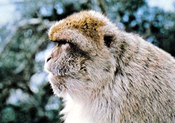
The mountains are home to the Amazigh (Berber) peoples, who have traditionally cultivated irrigated fields in the well-watered valleys. Ecologically, they host unique biodiversity, including the Barbary macaque, the only African ape found north of the Sahara.56
How do oasis towns support life in the Sahara Desert?
Oasis towns are essential hubs of life in the Sahara Desert, supporting two-thirds of the desert’s sedentary population by providing a reliable, perennial supply of fresh water. These fertile tracts rely on underground water sources, such as springs, wells, and artesian aquifers, which are often fed by distant sandstone intake areas.89
To maximize this limited resource, inhabitants utilize various irrigation techniques, including:
- Traditional methods: The use of foggaras (inclined underground tunnels), gueltas (permanent pools), and water-lifting devices like the shadoof or animal-driven noria (Persian wheel).9
- Modern technology: Many areas have transitioned to motorized pumps to access groundwater more efficiently.9
Agriculture in these oases is intensive, often organized into small “gardens” maintained by significant hand labor. The date palm serves as the primary food source, providing shade that allows for the cultivation of citrus fruits, figs, vegetables, and cereals like wheat, barley, and millet.89
What impact did the French occupation have on Moroccan history?
The French occupation of Morocco, established as a protectorate in 1912, fundamentally reshaped the nation’s political, social, and urban landscape until independence in 1956.1213
Administrative and Urban Transformation
Under the first resident general, Louis-Hubert-Gonzalve Lyautey, the French implemented a policy of co-opting the Moroccan elite to maintain a facade of the sultan’s sovereignty while French officials held real authority. This period saw the creation of Rabat as the new administrative capital and the rapid development of Casablanca into a major industrial port. Lyautey’s urban planning strategy involved building modern European cities separate from traditional medinas, preserving the latter while modernizing infrastructure.1412
Nationalist Resistance
The occupation inadvertently catalyzed a unified national identity. French attempts to divide the population—most notably through the Berber Decree of 1930, which sought to separate Arabs and Imazighen—backfired, sparking widespread nationalist protests.1415
Muhammad V emerged as a central figure of resistance. By refusing to sign French decrees and advocating for sovereignty, he became a national hero. His 1953 deportation by the French only intensified anti-colonial sentiment and guerrilla activity, ultimately forcing France to negotiate the end of the protectorate and recognize Moroccan independence in 1956.1315
Sources
- Al-Rachidia — Encyclopædia Britannica
- Atlas Mountains — Encyclopædia Britannica
- Exploring 7 of Earth’s Great Mountain Ranges - Atlas Mountains — Encyclopædia Britannica
- Atlas Mountains - Resources — Encyclopædia Britannica
- Morocco - Relief of Morocco — Encyclopædia Britannica
- Atlas Mountains - Climate of the Atlas Mountains — Encyclopædia Britannica
- High Atlas — Encyclopædia Britannica
- oasis — Encyclopædia Britannica
- Sahara - People of the Sahara — Encyclopædia Britannica
- Desert - Population and community development and structure — Encyclopædia Britannica
- Nile River - Irrigation — Encyclopædia Britannica
- Morocco - The pre-World War II period — Encyclopædia Britannica
- Morocco - The French protectorate (1912–56) — Encyclopædia Britannica
- Morocco - Decline of traditional government (1830–1912) — Encyclopædia Britannica
- Morocco - The French Zone — Encyclopædia Britannica
- Muḥammad V — Encyclopædia Britannica
Published on · 3 min read