Continental Shelf
The formation and characteristics of continental shelves are fundamentally shaped by their plate tectonic setting. Geologists categorize these margins into…
How does the formation of continental shelves relate to plate tectonics?
The formation and characteristics of continental shelves are fundamentally shaped by their plate tectonic setting. Geologists categorize these margins into two primary types based on their tectonic activity:
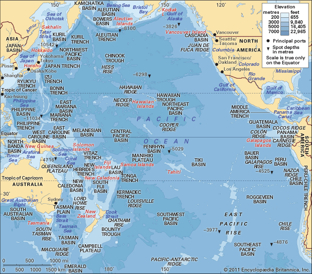
- Active Margins: Found along the Pacific Ocean, these shelves occur where continental plates terminate at subduction zones or fracture zones. Because they are tectonically active, these shelves tend to be steep, deformed, and covered by only a thin layer of erosional debris.1
- Passive (Trailing-Edge) Margins: Found along the Atlantic Ocean, these shelves represent the remnants of continental edges that split apart millions of years ago. They exhibit little tectonic deformation and are characterized by a thick accumulation of sedimentary material—such as sand, silt, and mud—that settled as the plate edges gradually contracted and subsided.1
Ultimately, the shelf’s surface is a “palimpsest,” where the interplay between tectonic setting, river-borne sediment supply, and wave energy continuously writes and erases the geological history of the margin.1
How do continental shelves influence ocean currents and weather patterns?
Continental shelves influence ocean currents and weather patterns primarily by acting as a boundary that shapes water movement and facilitates the exchange of heat and moisture with the atmosphere.
Influence on Ocean Currents
Continental shelves play a critical role in the formation of density currents. In high-latitude regions and marginal seas, intense cooling or evaporation creates cold, salty water that is denser than the surrounding ocean. This dense water often accumulates on the continental shelf before spilling over the shelf break and descending the continental slope as a “dense overflow.” These currents are then deflected by the Coriolis force and bottom friction, eventually contributing to the deep-ocean circulation patterns that distribute water globally.7
Influence on Weather Patterns
The relationship between the ocean and the atmosphere is driven by the transfer of heat and moisture. The surface layer of the ocean acts as a massive reservoir of heat, which is continuously stirred by winds and waves.8
- Heat Exchange: Ocean currents move warm water from the tropics toward the poles and cold water toward the tropics, strongly influencing the climate of coastal areas.8
- Storm Development: Warm ocean water provides the energy necessary for the development of tropical cyclones and extratropical cyclones.8
- Feedback Loops: Large-scale climate patterns, such as El Niño, arise from complex interactions between the ocean surface and the troposphere. Temperature anomalies in the ocean’s surface layer can persist for seasons or years, creating long-term impacts on regional weather.8
What are the typical physical characteristics of continental shelves?
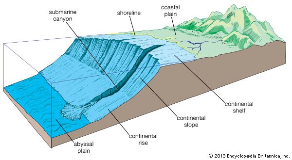
Continental shelves are the submerged extensions of continental landmasses, characterized by several distinct physical features:
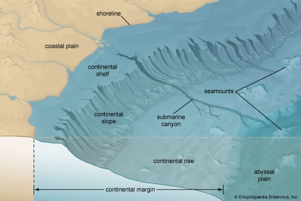
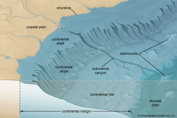
- Dimensions and Slope: A typical shelf extends from the coast to a depth of 100–200 metres (330–660 feet), with an average width of about 65 km (40 miles). They are generally inclined seaward at a gentle slope of approximately 0.1°.4
- Shelf Break: Most shelves terminate at a seaward edge known as the shelf break, where the gradient increases markedly as it transitions into the continental slope.41
- Surface Relief: While often relatively level, shelf surfaces are not perfectly smooth. They feature small hills, ridges, shallow depressions, and valleylike troughs. In some areas, deep, V-shaped submarine canyons cut into the shelf.4
- Sediment Composition: Shelves are typically covered by layers of sand, silts, and silty muds. These deposits are constantly reworked by currents, storms, and wave energy, which winnow out finer materials.49
- Tectonic Variability: The physical character of a shelf is heavily influenced by its tectonic setting. Shelves on active margins are often narrow, steep, and deformed, while those on passive margins are typically broader and accumulate thicker layers of sediment.49
What is a continental shelf and how is it defined in geological terms?
A continental shelf is a broad, relatively shallow submarine terrace that forms the submerged edge of a continental landmass. Geologically, it is a continuation of the continental crust, often sharing similar geological characteristics with the adjacent exposed land.21
In geological and oceanographic terms, the shelf is defined by several key features:
- Structure: It typically extends from the coast to a depth of 100–200 metres (330–660 feet), with an average width of approximately 65–75 km (40–45 miles).14
- Boundary: The seaward edge is marked by the shelf break, a zone where the seafloor gradient increases rapidly, transitioning into the steeper continental slope.14
- Topography: Most shelves exhibit a gently rolling topography known as “ridge and swale,” though they can also feature submarine canyons, hills, and depressions.21
- Tectonic Setting: Their formation is often explained through plate tectonics. Shelves on active margins (like the Pacific coast) tend to be narrow and deformed, while those on passive, trailing-edge margins (like the Atlantic coast) are typically broader and accumulate thicker sedimentary deposits.101
Sources
- continental shelf - Origin — Encyclopædia Britannica
- continental shelf — Encyclopædia Britannica
- continental slope — Encyclopædia Britannica
- continental shelf - Structure — Encyclopædia Britannica
- plate tectonics - Mountain building — Encyclopædia Britannica
- plate tectonics - Convergent margins — Encyclopædia Britannica
- Climate - Climate and the oceans — Encyclopædia Britannica
- density current - Density currents originating from marginal seas — Encyclopædia Britannica
- shelf break — Encyclopædia Britannica
- ocean - Major subdivisions of the oceans — Encyclopædia Britannica
- continental margin — Encyclopædia Britannica
Published on · 4 min read