Cordillera Central
The Cordillera Central presents significant challenges for infrastructure development in Puerto Rico primarily due to its rugged topography. As the island's…
What challenges does the Cordillera Central pose for infrastructure development in Puerto Rico?
The Cordillera Central presents significant challenges for infrastructure development in Puerto Rico primarily due to its rugged topography. As the island’s interior mountain range, it features high elevations, such as the island’s highest peak, Cerro de Punta, which reaches 4,390 feet (1,338 metres).1
The terrain is characterized by complex geological features, including limestone formations and granitic outcrops, which complicate large-scale construction and transportation projects. Furthermore, the region is a humid tropical environment, which often necessitates specialized engineering to manage water runoff and soil stability. While these mountains are vital for hydroelectric power and water supply through the management of major rivers like the Arecibo and La Plata, the steep and uneven landscape inherently limits the expansion of traditional infrastructure networks.1
What role does the Cordillera Central play in Puerto Rico’s water resources?
The Cordillera Central serves as the vital hydrological backbone of Puerto Rico. Because the island’s precipitation is concentrated on the north-facing mountain slopes, the range acts as the primary source for many of the island’s permanent rivers, including the Grande de Arecibo, La Plata, and Grande de Loíza rivers.12
These rivers are essential for the island’s infrastructure, as they are harnessed extensively for municipal water supplies, irrigation, and the generation of hydroelectric power. While rivers on the southern side of the island are often dry for much of the year, the interior mountains ensure a consistent flow toward the north and west coasts, supporting both human consumption and agricultural needs. By capturing and channeling rainfall, the Cordillera Central remains the most critical component in managing Puerto Rico’s water resources.12
How does the Cordillera Central affect Puerto Rico’s climate and ecosystems?
The Cordillera Central acts as a critical climatic barrier that dictates the distribution of rainfall and temperature across Puerto Rico. By intercepting the moisture-laden northeast trade winds, the mountain range forces air to rise and cool, resulting in heavy precipitation on the windward northern slopes. Conversely, this creates a rain shadow effect on the southern side, leading to significantly drier conditions in areas like Ponce.14
This elevation-driven variation also influences local temperatures; while the lowlands maintain an average of about 78 °F (26 °C), the highlands experience cooler temperatures, averaging a few degrees lower. These diverse microclimates support varied ecosystems, ranging from the humid, lush environments found in the higher elevations—such as those within the Caribbean National Forest—to the more arid landscapes of the southern coast.14
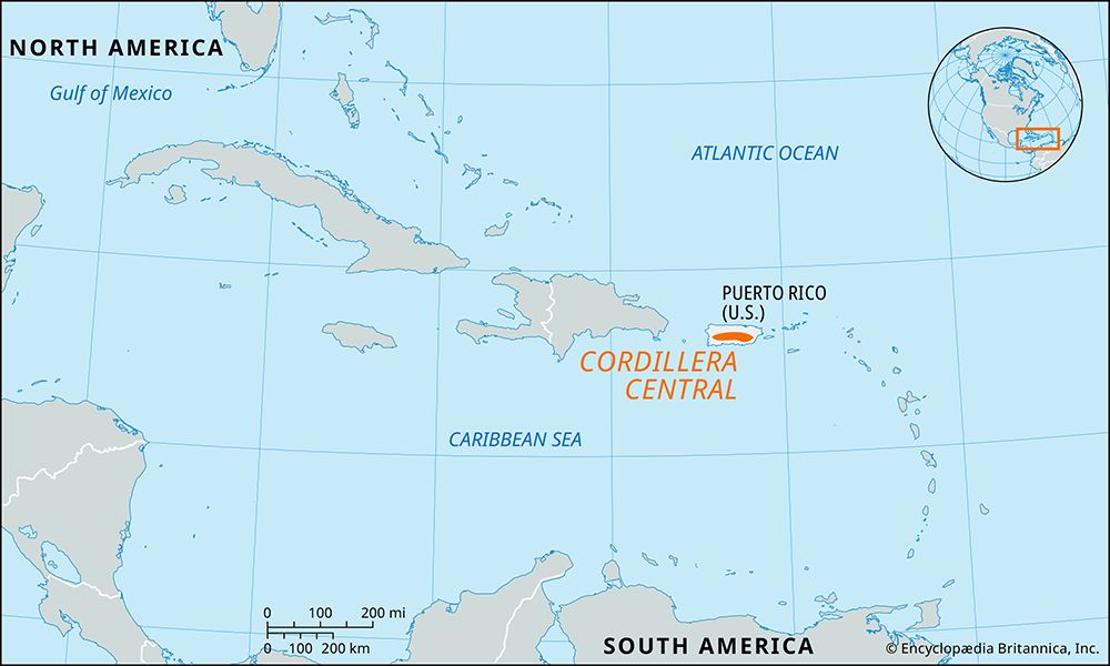
What is the Cordillera Central and where is it located in Puerto Rico?
The Cordillera Central is a limestone mountain range that forms the interior of Puerto Rico. It is the primary mountain system of the island and consists of three distinct sections:
- The Cordillera Central proper: This section occupies the west-central part of the island, extending approximately 50 miles (80 km) from San Germán in the west to the watershed between the Manatí and La Plata rivers in the east-central region. It contains the island’s highest peak, Cerro de Punta, which reaches an elevation of 4,390 feet (1,338 metres) north of Ponce.
- Sierra de Cayey: Located to the east of the Cordillera Central, this range features a gradual transition from the central mountains and reaches heights of up to 3,000 feet (900 metres).
- Sierra de Luquillo: Situated in the northeastern part of the island, this range is separated from the Sierra de Cayey by the Caguas, Gurabo, and Blanco valleys.
Sources
- Cordillera Central — Encyclopædia Britannica
- Puerto Rico - Drainage and soils — Encyclopædia Britannica
- Puerto Rico - Relief — Encyclopædia Britannica
- Puerto Rico - Climate — Encyclopædia Britannica
- Andes Mountains - Physiography of the Northern Andes — Encyclopædia Britannica
Published on · 3 min read