Cumberland River
When Europeans began arriving in the region of present-day Tennessee in the 18th century, the area was primarily inhabited by the Chickasaw in the west and…
What Native American tribes originally inhabited the Cumberland River region?
When Europeans began arriving in the region of present-day Tennessee in the 18th century, the area was primarily inhabited by the Chickasaw in the west and the Cherokee in the east.12
Regarding the Cumberland River region specifically, the Shawnee are also historically significant. During the 17th century, the Shawnee were displaced from their homes by the Iroquois, leading them to scatter into various areas, including the Cumberland Valley, before eventually reuniting in Ohio after 1725.3
It is important to acknowledge that these indigenous groups were part of a long history of human habitation in the region, which included earlier Paleo-Indian, Woodland, and Mississippian cultures. By the 19th century, most of these native peoples were forcibly removed from the state to reservations in what is now Oklahoma.12
What are some of the major tributaries of the Cumberland River?
The Cumberland River, which flows through Kentucky and Tennessee, is fed by several significant tributaries that join the main stem downstream from the Cumberland Falls. These tributaries include:
- In Kentucky: The Laurel River, Rockcastle River, South Fork, and the Little River.5
- In Tennessee: The Obey River, Caney Fork, Stones River, Harpeth River, and Red River.5
Several of these tributaries are integral to the region’s water management and power infrastructure. For instance, the Dale Hollow Dam is located on the Obey River, and the Center Hill Dam is situated on the Caney Fork.5

What is the geographical location and course of the Cumberland River?
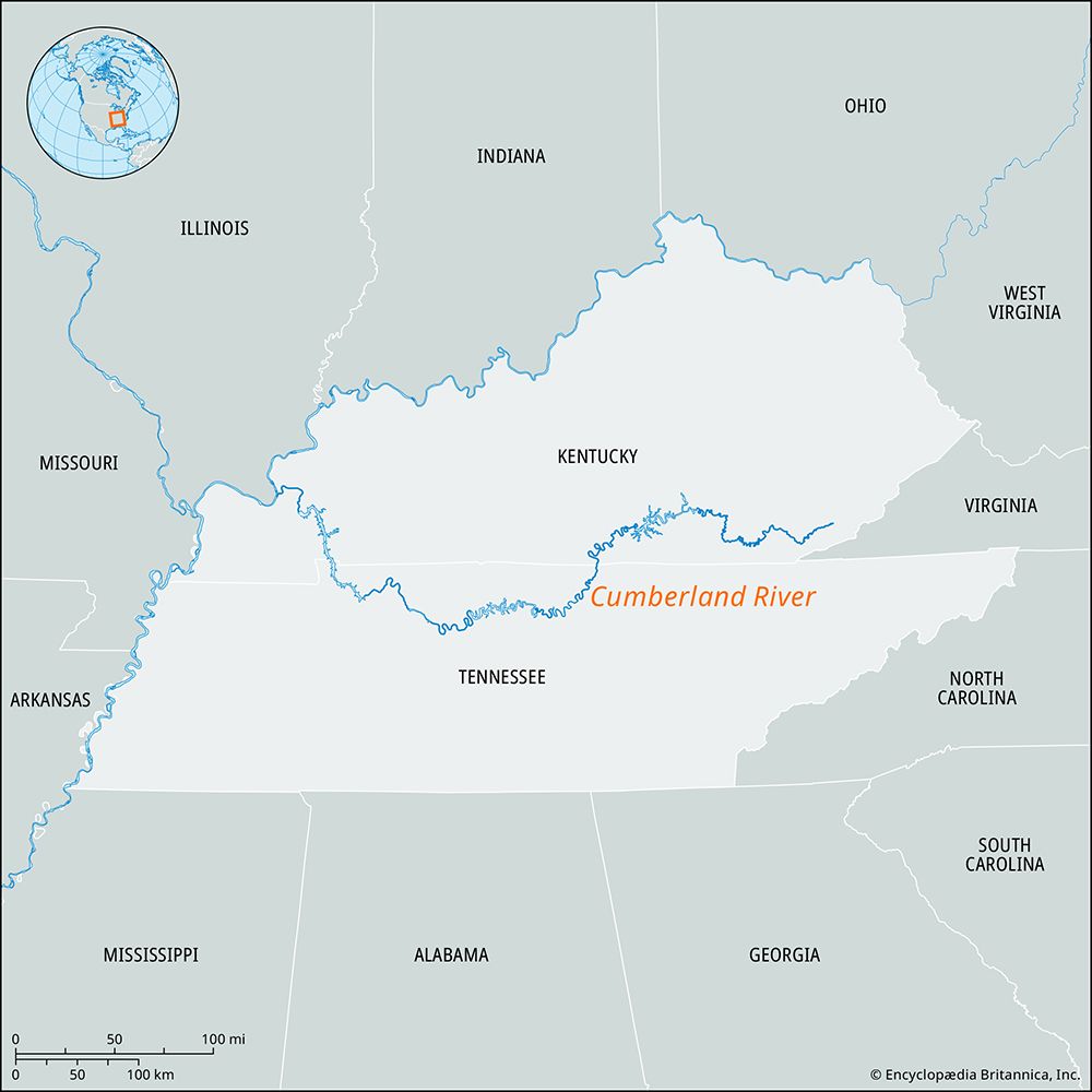
The Cumberland River originates on the Cumberland Plateau in Harlan County, southern Kentucky, formed by the confluence of the Poor and Clover forks.5
The river follows a 687-mile (1,106 km) course, characterized by distinct geographical stages:
- Mountainous Headwaters: From its source to the Cumberland Falls in Whitley County, Kentucky, the river functions as a mountain stream.5
- Gorge Section: Between Williamsburg, Kentucky, and the Kentucky-Tennessee state line, the river flows through a gorge flanked by cliffs reaching 300–400 feet (90–120 meters) in height.5
- Basin and Plain: The river enters the central limestone basin of Tennessee, eventually turning north to cross the plains of western Kentucky.5
- Confluence: It empties into the Ohio River at Smithland, Kentucky, located 12 miles upstream from the mouth of the Tennessee River5.
The river drains an area of 18,080 square miles (46,830 square km), with Nashville serving as the largest city along its banks.5
What dams and reservoirs have been built on the Cumberland River, and why?
A series of dams and reservoirs were developed on the Cumberland River as part of the Tennessee Valley Authority (TVA) system to provide flood control, generate power, and facilitate navigation.5
Key infrastructure projects include:
- Wolf Creek Dam (1952): Located in Russell County, Kentucky, this dam created Lake Cumberland, which serves the dual purpose of flood control and power generation.5
- Dale Hollow Dam (1953): Situated on the Obey River, this large power dam is a major component of the system.5
- Center Hill Dam (1951): Located on the Caney Fork, this facility also functions as a large power dam.5
- Old Hickory Dam: Positioned upstream from Nashville, this dam ponds water to Carthage, establishing the head of navigation on the river.5
- Cheatham Dam: Located upstream from Clarksville.5
- Barkley Dam (1966): This structure is responsible for controlling the lower portion of the river.5
These projects transformed the river into a managed waterway, balancing the needs for energy production and regional water management.5
Sources
- Cherokee - Early colonial period — Encyclopædia Britannica
- Tennessee - Prehistory and European settlement — Encyclopædia Britannica
- Tennessee - Population composition — Encyclopædia Britannica
- Shawnee — Encyclopædia Britannica
- Cumberland River — Encyclopædia Britannica
- Tennessee River — Encyclopædia Britannica
Published on · 3 min read