Jequitinhonha River
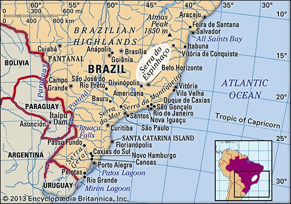
The Jequitinhonha River is a river located in eastern Brazil. It originates in the Serra do Espinhaço mountains, south of Diamantina in the state of Minas…
What is Jequitinhonha River?
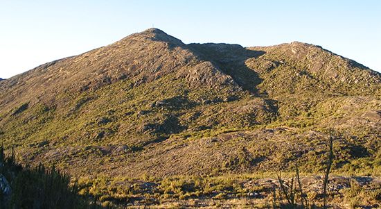
The Jequitinhonha River is a river located in eastern Brazil. It originates in the Serra do Espinhaço mountains, south of Diamantina in the state of Minas Gerais.1
The river flows northward and then east-northeastward across the uplands, covering a course of approximately 680 miles (1,090 km). At Salto da Divisa, the river features the Cachoeira do Salto Grande, a waterfall measuring 140 feet (43 meters) in height. Upon reaching the coastal plain near the city of Jequitinhonha—where it is also known as the Rio Grande do Belmonte—it continues to its mouth at the Atlantic Ocean near Belmonte in Bahia state. While the river is navigable in certain sections, it flows through one of the most impoverished regions of Minas Gerais.1
What are the main mountain ranges in Brazil?
Brazil’s topography is dominated by the Brazilian Highlands, a vast region of plateaus and mountain ranges covering more than half of the country. A massive escarpment marks the eastern edge of these highlands, extending 1,600 miles along the Atlantic coast and forming several significant mountain ranges.3
Key Mountain Ranges and Highlands
- Serra do Mar: The largest segment of the coastal escarpment, extending from Minas Gerais to Paraná. Near Rio de Janeiro, it is known as the Serra dos Órgãos.34
- Serra da Mantiqueira: Located north of the Serra do Mar, this range contains some of Brazil’s highest peaks, including Bandeira Peak (9,482 feet) and Agulhas Negras Peak (9,143 feet).3
- Espinhaço Mountains: Stretching from central Minas Gerais into Bahia, this range is a vital source of minerals like iron ore, manganese, and quartz.35
- Chapada Diamantina: A prominent upland region in Bahia state.34
- Serra Geral de Goiás: A range separating the states of Goiás and Tocantins from Bahia.3
- Other Ranges: These include the Serra dos Aimorés, the Serra dos Carajás in Pará, and the Parecis Upland in the west.3
How do rivers shape the landscape of eastern Brazil?
Rivers play a significant role in shaping the landscape of eastern Brazil, primarily by carving through the rugged terrain of the Brazilian Highlands. Because many of these rivers originate in the interior uplands and descend toward the Atlantic Ocean, they often feature steep gradients, resulting in the formation of dramatic waterfalls and rapids where they drop from the plateaus to the coastal plains.17
Key ways these rivers influence the topography include:
- Erosion and Dissection: Rivers like the São Francisco River and the Jequitinhonha River have deeply dissected the highland plateaus, creating ravines and valleys as they flow northward or eastward.174
- Waterfall Formation: The transition from the highlands to the coast is marked by significant drops. For example, the Jequitinhonha River features the 140-foot Cachoeira do Salto Grande, while the São Francisco River is known for the Paulo Afonso Falls.17
- Sedimentation: As these rivers reach the coastal plains, they deposit sediments, helping to shape the coastal environment before emptying into the ocean.1
While some sections are navigable, the steep descent of many eastern rivers limits their use for large-scale waterborne traffic, though they are frequently harnessed for hydroelectric power.7
What is the significance of the Serra do Espinhaço?
The Espinhaço Mountains are a significant mountain range in eastern Brazil, spanning the states of Minas Gerais and Bahia. Their importance is defined by both their geographical role and their immense economic value.
Geographical Significance
Geographically, the range acts as a vital drainage divide. Together with the Diamantina Upland, the Espinhaço Mountains separate the tributaries of the São Francisco River from the various streams that flow eastward directly into the Atlantic Ocean.6
Economic Significance
The mountains have been a cornerstone of Brazil’s economy for centuries:
- Historical Mining: Since the early 18th century, the region has been a major source of gold, diamonds, and various semiprecious stones.6
- Modern Industry: Today, the range is economically vital for its vast deposits of high-grade iron ore and manganese.6
- Global Resource: The Espinhaço Mountains are recognized as the world’s primary source of quartz crystals.6
Sources
- Jequitinhonha River — Encyclopædia Britannica
- Jequitinhonha — Merriam-Webster
- Brazil - Brazilian Highlands — Encyclopædia Britannica
- Brazilian Highlands — Encyclopædia Britannica
- Serra do Mar — Encyclopædia Britannica
- Espinhaço Mountains — Encyclopædia Britannica
- Brazil - Rivers of Brazil — Encyclopædia Britannica
- Brazil - Amazon lowlands — Encyclopædia Britannica
- Amazon River - Landforms and drainage patterns — Encyclopædia Britannica
Published on · 3 min read