Mackenzie River
The Mackenzie River is a major river system in northwestern North America and possesses the largest drainage basin in Canada. Spanning 2,635 miles (4,241 km)…
What is Mackenzie River?
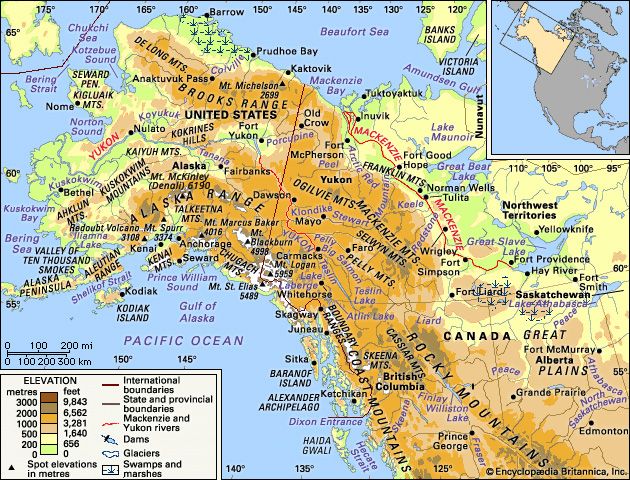
The Mackenzie River is a major river system in northwestern North America and possesses the largest drainage basin in Canada. Spanning 2,635 miles (4,241 km) from the headwaters of the Finlay River to the Beaufort Sea in the Arctic Ocean, the system drains approximately 697,000 square miles.1
The river flows through a sparsely populated region characterized by a harsh winter climate and vast, unspoiled wilderness. While the basin contains significant natural resources—including petroleum, natural gas, uranium, and diamonds—the economy is also supported by commercial fishing in large lakes like Great Slave Lake and Lake Athabasca, as well as limited forestry and agriculture in the southern reaches. The river itself serves as a vital transportation route, though its water is not currently utilized for hydroelectric power.12
What is the Canadian Shield and how does it affect the river’s flow?
The Canadian Shield is the largest physiographic region in Canada, covering approximately half of the country’s landmass and centered on Hudson Bay. It is composed of some of the world’s oldest Precambrian rocks, which have been shaped over time by mountain-building, erosion, and extensive glaciation. The latter process stripped away surface materials and left behind a rugged landscape characterized by numerous lakes, swamps, and rocky hills.31
Regarding the Mackenzie River, the Canadian Shield acts as a structural boundary that influences the river’s drainage basin. While the Mackenzie flows primarily through the Mackenzie Lowlands, its eastern edge is defined by the ancient, rocky hills of the Canadian Shield, which slope upward to elevations of about 1,000 feet (300 metres).4
The Shield contributes to the river system by feeding it with shorter, eastward-originating rivers that drain its low, rocky terrain. Because the Shield is characterized by a complex network of lakes and wetlands formed by glacial depressions, it serves as a significant source of water storage for the broader northern drainage pattern.516
What are the Athabasca Tar Sands and why are they important?
The Athabasca Tar Sands are deposits of loose sand or partially consolidated sandstone saturated with highly viscous bitumen, located along the Athabasca River near Fort McMurray in northern Alberta, Canada.82
These deposits are significant for several reasons:
- Energy Reserves: They contain an enormous reserve of petroleum, serving as a vital source of fossil fuel. The bitumen is extracted and upgraded into synthetic crude, naphtha, kerosene, and gas oil.8
- Economic Impact: The region hosts the world’s only commercial projects for synthetic oil production from tar sands. While development was initially limited by high costs, production increased significantly in the 1980s as conventional oil fields were depleted, making it a cornerstone of the regional and national economy.8910
- Environmental Concerns: The extraction and processing of these sands have raised serious ecological issues. Processing contributes to the pollution of the Athabasca River and generates emissions that lead to acid rain, which threatens surrounding forests and wildlife.11
How do people live in the harsh climate of the Mackenzie River basin?
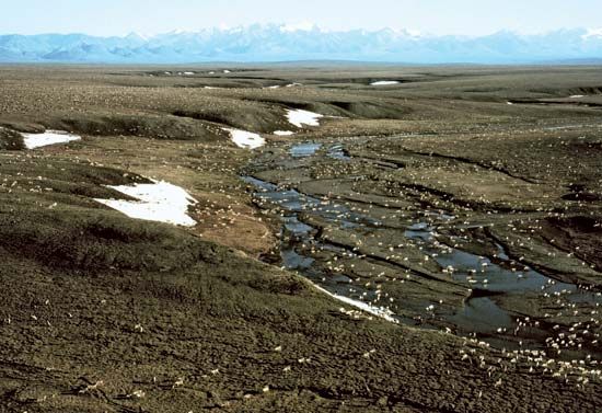
Life in the Mackenzie River basin is shaped by a harsh, cold climate characterized by long, freezing winters and short growing seasons. To thrive in this environment, residents have adapted their infrastructure, economy, and daily practices to the unique challenges of the North.121
Infrastructure and Construction
The presence of permafrost—permanently frozen subsoil—presents significant construction challenges. To ensure stability, buildings are often placed on wooden piles sunk into the frozen ground. In towns like Inuvik, engineers utilize “utilidors,” which are raised, insulated conduits that house water, sewer, and heating pipes above the ground to prevent them from freezing or shifting.122
Economy and Sustenance
While the region was historically driven by the fur trade, the modern economy relies heavily on petroleum, natural gas, and mining. Agriculture is limited by the climate; although some crops can be grown in the south, most food is imported, which increases costs. Many residents supplement their diets through commercial fishing in lakes like Great Slave Lake or by hunting and trapping, which remain important cultural and economic activities for the Indigenous population.1314
Sources
- Mackenzie River — Encyclopædia Britannica
- Mackenzie River - People and economy — Encyclopædia Britannica
- Canada - The Canadian Shield — Encyclopædia Britannica
- Canadian Shield: Top Questions — Encyclopædia Britannica
- Mackenzie River - The upper course — Encyclopædia Britannica
- Canada - Drainage of Canada — Encyclopædia Britannica
- river - Rivers as agents of landscape evolution — Encyclopædia Britannica
- tar sand — Encyclopædia Britannica
- Athabasca River — Encyclopædia Britannica
- Alberta - Resources and power — Encyclopædia Britannica
- Saskatchewan - Pollution — Encyclopædia Britannica
- Northwest Territories - Land — Encyclopædia Britannica
- North America - The Arctic zone — Encyclopædia Britannica
- Mackenzie River - The delta region — Encyclopædia Britannica
- Northwest Territories - Agriculture, forestry, hunting, and fishing — Encyclopædia Britannica
Published on · 3 min read