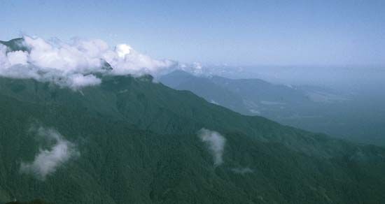
Maoke Mountains
The Maoke Mountains (also known as the Snow Mountains) form the westernmost segment of the central highlands of New Guinea, located within the Indonesian…
What is Maoke Mountains?
The Maoke Mountains (also known as the Snow Mountains) form the westernmost segment of the central highlands of New Guinea, located within the Indonesian province of Papua.12
Spanning approximately 430 miles (692 km), this rugged range is divided into the Sudirman range in the west and the Jayawijaya range in the east. Much of the terrain sits above 12,000 feet (3,660 metres), which marks the approximate tree line for the region. Several peaks rise above the 14,500-foot (4,400-metre) snow line, including the island’s highest point, Jaya Peak, which reaches an elevation of 16,024 feet (4,884 metres).1
What is the significance of Puncak Jaya?
Puncak Jaya, also known as Jaya Peak, holds significant status as the highest mountain on the island of New Guinea and the highest island peak in the world. Located in the Sudirman Range within the Indonesian province of Central Papua, it is also the highest summit in the southwestern Pacific.34
The peak is historically notable for its former glaciation; however, climate change has had a profound impact, with more than 99 percent of its ice cover melting by 2025. While Dutch explorer Hendrik A. Lorentz reached the mountain’s snowfield in 1909, the summit remained unclimbed until 1962, when an expedition led by Austrian mountaineer Heinrich Harrer successfully reached the top. Formerly referred to as Mount Carstensz, the mountain serves as a critical geographical landmark within the Maoke Mountains.oke Mountains](https://www.britannica.com/place/Maoke-Mountains/Introduction#ref1).341
How does the snow line affect the local environment?
The snow line is the lower topographic limit where permanent snow cover persists, representing a critical boundary that shapes local environments through its influence on climate, vegetation, and soil processes.
Climatic and Ecological Impact
The position of the snow line is determined by the balance between snowfall and ablation (melting and evaporation). Its altitude varies significantly based on latitude, aspect, and local temperature, creating distinct environmental zones.5
- Vegetation Patterns: The snow line and the associated tree line define the limits of plant life. Above the tree line, harsh conditions—including low temperatures, high winds, and a short growing season—restrict growth to alpine vegetation like grasses and forbs. In temperate regions, the duration of snow cover into the spring directly dictates when vegetation emerges, influencing the land’s utility for grazing.6
- Soil and Permafrost: Snow cover acts as an insulating layer that regulates heat flow between the ground and the atmosphere. In permafrost regions, thick snow can prevent heat from escaping the ground during winter, keeping the permafrost warmer. Conversely, the absence of snow can lead to deeper freezing. Furthermore, the freeze-thaw cycles associated with seasonal snow and ice contribute to soil movement, such as solifluction, which shapes the landscape through the formation of patterned ground.78
- Biological Adaptation: In temperate mountains, the seasonal snowpack triggers a rapid surge of plant growth and flowering upon melting. Many animals have adapted to these cycles, either by migrating to lower altitudes or by utilizing the insulated environment beneath the snow for winter survival.9
What are the Sudirman and Jayawijaya ranges?
The Sudirman Range and the Jayawijaya Mountains together form the Maoke Mountains, which constitute the central highlands of the island of New Guinea in Indonesia.
The Sudirman Range
Located in the western section of the Maoke Mountains within the province of Central Papua, this rugged range extends for approximately 200 miles (320 km). It is characterized by high elevations, with no passes estimated to be lower than 13,000 feet (4,000 meters). The range is home to Jaya Peak, the highest island peak in the world at 16,024 feet (4,884 meters), as well as Mount Pilimsit.11112
The Jayawijaya Mountains
The Jayawijaya Mountains comprise the eastern section of the Maoke range, extending 230 miles (370 km) from the Sudirman Range toward the border with Papua New Guinea. Much of this region is situated within the province of Highland Papua. The highest point in this eastern segment is Trikora Peak, which reaches an elevation of 15,580 feet (4,750 meters).1213
Sources
- Maoke Mountains — Encyclopædia Britannica
- Maoke Mountains — Merriam-Webster
- Jaya Peak — Encyclopædia Britannica
- Puncak Jaya — Merriam-Webster
- Snow line — Encyclopædia Britannica
- Mountain ecosystem - Environment — Encyclopædia Britannica
- Tree - Tree lines — Encyclopædia Britannica
- permafrost - Effects of solar radiation, vegetation, and snow cover — Encyclopædia Britannica
- Tundra - Soils — Encyclopædia Britannica
- Mountain ecosystem - Population and community development and structure — Encyclopædia Britannica
- Sudirman Range — Encyclopædia Britannica
- Highland Papua — Encyclopædia Britannica
- Central Papua — Encyclopædia Britannica
- Jayawijaya Mountains — Encyclopædia Britannica
Published on · 3 min read