Mapimí Basin
The Mapimí Basin is an enclosed depression located in northern Mexico. Spanning approximately 50,000 square miles (129,500 square km), it is situated within…
What is Mapimí Basin?
The Mapimí Basin is an enclosed depression located in northern Mexico. Spanning approximately 50,000 square miles (129,500 square km), it is situated within the arid Mesa del Norte at an average elevation of 3,000 feet (900 metres).1
Structurally, the basin is similar to the Basin and Range Province found in the United States. While it was historically viewed as an unreclaimable desert, the implementation of irrigation has allowed the region to support the cultivation of cotton, wheat, and alfalfa. The southern portion of the basin contains the Laguna District, which includes major urban centers such as Gómez Palacio, Torreón, and San Pedro de las Colonias, all of which are connected by highway and rail networks.1
What is the Basin and Range Province?
The Basin and Range Province is an arid physiographic region covering much of the western and southwestern United States, including nearly all of Nevada, the western half of Utah, southeastern California, and southern Arizona, extending into northwestern Mexico.2
Topography and Geology
The province is characterized by a distinct topography of roughly parallel, north-south-trending mountain ranges separated by nearly flat desert plains or basins. The basins typically sit 4,000–5,000 feet (1,200–1,500 meters) above sea level, with mountain ranges rising an additional 3,000–5,000 feet above them.2
This landscape resulted from complex crustal extension, which broke the region into fault-block mountains and downdropped basins. These basins often lack drainage outlets, leading to the formation of salt lakes—such as the Great Salt Lake—or ephemeral playas.32
Regional Sections
- Great Basin: The northern half of the province.2
- Sonoran Desert: Extends into Sonora, Mexico.2
- Salton Trough: A concave basin containing the Salton Sea, which descends below sea level.2
- Mexican Highland: Located east of the Sonoran Desert, sharing characteristics with the Great Basin.2
How does irrigation transform desert regions into farmland?
Irrigation transforms arid desert regions into productive farmland by providing the necessary moisture to soils that are often rich in nutrients but lack sufficient water for agriculture. By tapping into subterranean water supplies, rivers, or reservoirs, farmers can cultivate crops such as cotton, wheat, and alfalfa in areas previously considered unreclaimable.45
The Process and Benefits
When water is applied to drylands, it enables the full use of modern agricultural technology, including the application of fertilizers and the implementation of suitable crop rotations. In many arid zones, high levels of solar energy combined with irrigated water create ideal conditions for intensive agriculture.46
Challenges and Sustainability
While irrigation is a powerful tool for land reclamation, it presents significant environmental risks:
- Salt Accumulation: Irrigation water often contains dissolved salts. As the water evaporates, these salts remain in the soil, which can dehydrate plants and reduce productivity.78
- Drainage Requirements: To prevent the buildup of salts, land must be properly drained. Without adequate drainage, productive land can turn into barren salt flats.698
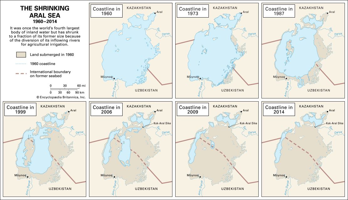
- Ecological Impact: Large-scale diversion of water sources can lead to severe ecological disasters, such as the shrinking of the Aral Sea, which resulted in extreme temperature shifts and health crises for local populations.6
What is the significance of the Laguna District?
The Laguna District is a significant agricultural region spanning western Coahuila and eastern Durango in northern Mexico. Its importance is rooted in its transformation from a large, grazing-focused hacienda into a center for intensive irrigation-based farming.10
Historical and Economic Significance
- Agrarian Reform: In 1936, President Lázaro Cárdenas implemented a major land-redistribution program, dividing the district into ejidos (communal lands) for local communities.10
- Water Management: The district relies on the Nazas River and the Aguanaval River for irrigation. To support this, the Lázaro Cárdenas and Francisco Zarco dams were constructed to control water flow, which significantly altered the region’s hydrology.1011
- Agricultural Output: The area became a major hub for cotton production, though it has faced challenges such as severe droughts in the 1950s that necessitated government-led relocation and new irrigation initiatives.10
The district also serves as a vital urban center, with major cities like Torreón and Gómez Palacio situated along the Nazas River.1011
Sources
- Mapimí Basin — Encyclopædia Britannica
- Basin and Range Province — Encyclopædia Britannica
- Tertiary Period - Volcanism and orogenesis — Encyclopædia Britannica
- Origins of agriculture - Irrigation — Encyclopædia Britannica
- salinity — Encyclopædia Britannica
- desertification - Irrigated croplands — Encyclopædia Britannica
- land reclamation - Reclamation of arid land — Encyclopædia Britannica
- Fruit farming - Irrigation — Encyclopædia Britannica
- Arabian Desert - Soils — Encyclopædia Britannica
- Laguna District — Encyclopædia Britannica
- Nazas River — Encyclopædia Britannica
Published on · 3 min read