Plateau
A plateau is an extensive area of flat upland that is characterized by low relative relief and significant altitude. While plateaus are elevated above the…
What is a plateau and how does it differ from other landforms?
A plateau is an extensive area of flat upland that is characterized by low relative relief and significant altitude. While plateaus are elevated above the surrounding terrain, they are distinguished from mountain ranges by their remarkably flat surfaces.1
Distinctions from Other Landforms
Plateaus are classified as tectonic landforms, meaning they are primarily produced by vertical crustal movements, volcanism, or thermal expansion. They differ from other landforms in the following ways:23
- Vs. Mountains: Unlike mountain ranges, which are defined by high relief and rugged peaks, plateaus maintain a broad, level top. Even when plateaus are formed by crustal shortening—a process that creates mountains—the plateau surface itself remains defined by flat, broad valleys or plains.12
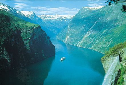
- Vs. Structural Landforms: While plateaus are tectonic in origin, many other features, such as sand dunes, fjords, and beaches, are structural landforms created by denudational processes like erosion and deposition from wind, water, or ice.3
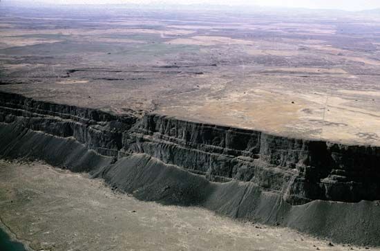
Plateaus are often bounded by steep slopes called escarpments, though some are enclosed by mountains. Their formation is typically attributed to thermal expansion of the lithosphere, crustal shortening, or extensive lava flows.12
How are plateaus formed through geological processes?
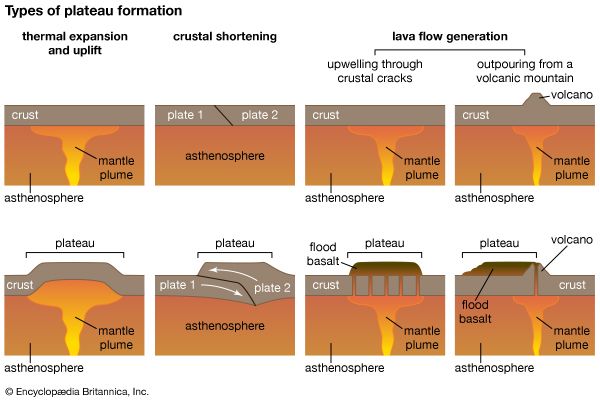
Plateaus are formed through three primary tectonic processes, often acting in combination:
1. Thermal Expansion
When the lithosphere is heated—often by an upwelling of hot material from the asthenosphere—the resulting thermal expansion causes the surface to uplift. If the original terrain was low and flat, it often retains its level surface as it rises. The Ethiopian Plateau and parts of East Africa were formed through this mechanism.2
2. Crustal Shortening
This process thickens the crust through folding or the thrusting of rock layers, creating high mountains. In regions with internal drainage, eroded material fills the basins between these mountains. Over time, these flat, sediment-filled valleys create a plateau, effectively acting as a mountain range buried in its own debris. Examples include the Plateau of Tibet and the Altiplano.2
3. Volcanism
Extensive lava flows, known as flood basalts or traps, can bury existing terrain under thick layers of volcanic rock. These flows often originate from hot spots and spread over vast distances, creating flat surfaces like the Columbia Plateau.2
What are the different types of plateaus, and how are they classified?
Plateaus are extensive areas of flat upland characterized by low relative relief and significant altitude, typically bounded by steep slopes known as escarpments. While they are often categorized by their geographic location or appearance, geologists classify them primarily based on the tectonic processes that created them.12
Classification by Formative Process
The differences among plateaus are ascribed to three primary geologic mechanisms, which often operate in combination:12
- Thermal Expansion: These plateaus form when the underlying lithosphere is heated by an upwelling of hot material from the asthenosphere. This causes the surface to uplift while maintaining its original flatness. Examples include the Ethiopian Plateau and parts of East Africa.2
- Crustal Shortening: These are essentially mountain ranges buried in their own debris. As mountains form through folding or thrusting, internal drainage systems deposit sediment into the intervening valleys. Over time, these filled basins create a flat-topped, high-elevation surface, such as the Plateau of Tibet or the Altiplano.2
- Volcanism: These plateaus are created by extensive lava flows, known as flood basalts or traps, which bury the preexisting terrain. The Columbia Plateau is a prominent example of this type.2
Additionally, some regions, such as the Piedmont in the United States, are described as rolling plateaus, though their formation is distinct from the large-scale tectonic processes mentioned above.7
How do erosion and weathering affect the shape and features of plateaus over time?
While tectonic processes build the major structures of plateaus, erosion and weathering are the primary forces that sculpt their individual features and relief over time. These processes work to reduce elevation differences, though plateaus can persist for hundreds of millions of years if erosion rates remain relatively slow.2
Erosional Sculpting
Erosion acts as a transformative agent, carving the flat surfaces of plateaus into distinct landforms:
- Canyons and Gorges: When tectonic uplift raises a plateau, it often “rejuvenates” local rivers, increasing their erosive power. These rivers entrench themselves into the plateau, creating deep, narrow canyons and gorges, such as the Grand Canyon on the Colorado Plateau) on the Colorado Plateau.12
- Mesas and Buttes: During the process of denudation, areas of harder, erosion-resistant rock act as protective caps. As surrounding softer rock is stripped away by wind and water, these resistant sections remain as flat-topped tablelands known as mesas or smaller, steep-sided hills called buttes.101
- Glacial Modification: In colder regions, glaciers can drastically reshape plateau landscapes. They erode valley walls and bases, often transforming V-shaped stream valleys into U-shaped valleys and carving amphitheatre-shaped hollows called cirques into the plateau surface.11
Climate Influence
The survival of a plateau’s flat surface is heavily dependent on climate. Plateaus formed by crustal shortening, which are essentially mountains buried in their own debris, generally survive only in dry climates where erosional forces are slow. In contrast, in wetter environments, more rapid erosion can quickly dissect and degrade these features.122
Sources
- plateau — Encyclopædia Britannica
- plateau - Formative processes — Encyclopædia Britannica
- plateau - Geographic distribution — Encyclopædia Britannica
- landform — Encyclopædia Britannica
- plateau — Merriam-Webster
- plateaus — Merriam-Webster
- continental plateau — Merriam-Webster
- piedmont — Encyclopædia Britannica
- Piedmont — Encyclopædia Britannica
- mesa — Encyclopædia Britannica
- glacial landform - Cirques , tarns, U-shaped valleys, arêtes, and horns — Encyclopædia Britannica
- river - Formation of canyons and gorges — Encyclopædia Britannica
- tectonic landform — Encyclopædia Britannica
- butte — Encyclopædia Britannica
Published on · 4 min read