Sevier Lake
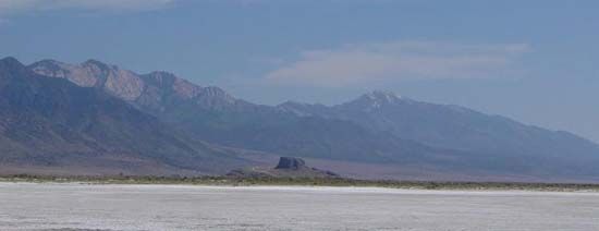
Sevier Lake is a body of water located in Millard County, western Utah, U.S. Situated in the Pahvant Valley at an elevation of approximately 4,500 feet…
What is Sevier Lake?
Sevier Lake is a body of water located in Millard County, western Utah, U.S. Situated in the Pahvant Valley at an elevation of approximately 4,500 feet (1,370 meters), it lies within an ecological transition zone between the Colorado Plateau and the Basin and Range geological province.1
The lake measures about 25 miles (40 km) long and up to 7 miles (11 km) wide. It serves as the terminus for the Sevier River, the longest river located entirely within Utah. Because the lake has no outlet, its waters are strongly saline, which has facilitated the development of local halite and potassium sulfate manufacturing facilities.12
What is the Great Salt Lake?
The Great Salt Lake is a large, saline lake located in northern Utah, U.S. It is the largest inland body of salt water in the Western Hemisphere and is one of the most saline bodies of water in the world.3
Key Characteristics
- Hydrology: The lake is fed primarily by the Bear, Weber, and Jordan rivers and has no outlet. Because natural evaporation exceeds the inflow from these rivers, the lake maintains a high level of salinity.3
- Fluctuations: Its size varies significantly based on evaporation rates and river flow. Its surface area has historically ranged from approximately 2,400 square miles (6,200 square km) to as low as 888 square miles (2,300 square km).3
- Origins: It is the largest remnant of the prehistoric freshwater Lake Bonneville, which covered much of western Utah during the Pleistocene Epoch.34
- Economic and Ecological Importance: The lake is a vital source of minerals, including salt, potassium, and magnesium. Its surrounding marshes and islands also serve as essential habitats for waterfowl and other wildlife.3
How do terminal lakes become saline?
Terminal lakes, also known as closed lakes, become saline primarily because they lack an outlet to discharge water. While these lakes receive water from rivers and streams—which carry small amounts of dissolved minerals—they lose water exclusively through [evaporation].8
Because evaporation removes only pure water molecules, the dissolved minerals and salts brought in by inflows remain behind and become increasingly concentrated over time. This process is most common in semiarid regions where evaporation rates are high. As the water level fluctuates due to climatic shifts or human water diversion, the concentration of these dissolved substances can rise significantly, sometimes reaching levels well above 300 grams per liter.89
Over time, these high concentrations can lead to the formation of chemical precipitates on the lake bed, such as halite, gypsum, and various carbonates.10
What is the Basin and Range province?
The Basin and Range Province is an arid, expansive physiographic region covering much of the western and southwestern United States, including nearly all of Nevada, the western half of Utah, southeastern California, and parts of Arizona and New Mexico, extending into northwestern Mexico.1213
Topography and Geology
The province is defined by a distinctive landscape of roughly parallel, north-south trending mountain ranges separated by nearly flat desert basins. These ranges are essentially large blocks of Earth’s crust that were uplifted, tilted, and faulted over millions of years. The basins between them are filled with alluvial debris eroded from the mountains, creating a complex, semidesert environment.121314
Key Features
- The Great Basin: The northern half of the province, known as the Great Basin, is characterized by an internal drainage system where water collects in closed basins rather than flowing to the sea, often forming salt lakes or playas.1213
- Geologic Activity: The region remains geologically active, with fresh fault surfaces and ongoing seismic activity indicating that the crustal movement continues to the present day.13
Sources
- Sevier Lake — Encyclopædia Britannica
- Sevier River — Encyclopædia Britannica
- Great Salt Lake — Encyclopædia Britannica
- Great Salt Lake — Merriam-Webster
- Utah - Plant and animal life — Encyclopædia Britannica
- Lake Bonneville — Encyclopædia Britannica
- Utah - Drainage — Encyclopædia Britannica
- Inland water ecosystem - Saline lakes — Encyclopædia Britannica
- lake - Water output — Encyclopædia Britannica
- lake - Chemical precipitates — Encyclopædia Britannica
- mining - Evaporation of seawater — Encyclopædia Britannica
- Basin and Range Province — Encyclopædia Britannica
- Great Basin — Encyclopædia Britannica
- tectonic basins and rift valleys - Basins and ranges — Encyclopædia Britannica
Published on · 3 min read