Tasman Sea
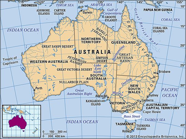
The Tasman Sea is a section of the southwestern Pacific Ocean. It is located between the southeastern coast of Australia and the island of Tasmania to the…
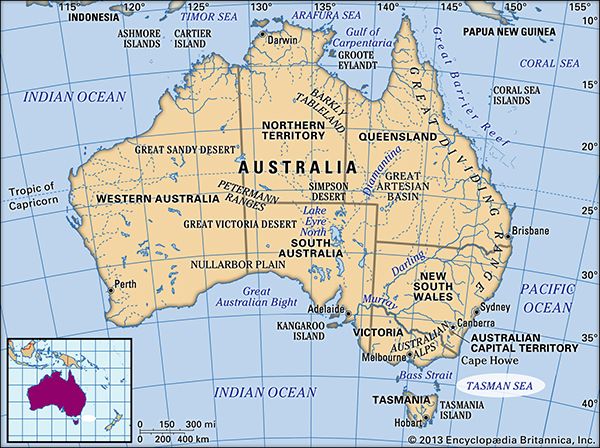
Where is the Tasman Sea located, and which countries border it?
The Tasman Sea is a section of the southwestern Pacific Ocean. It is located between the southeastern coast of Australia and the island of Tasmania to the west, and New Zealand to the east.1
What are the main geographical features of the Tasman Sea?
The Tasman Sea is a vast body of water in the southwestern Pacific Ocean, covering approximately 900,000 square miles (2,300,000 square km) with a width of about 1,400 miles (2,250 km). Its primary geographical and physical features include:1
- Seafloor Topography: The sea reaches depths exceeding 17,000 feet (5,200 meters). Its most distinctive underwater feature is the [Tasman Basin].1
- Connectivity: It connects to the Indian Ocean via the Bass Strait and to the Pacific Ocean through the Cook Strait. To the north, it merges with the Coral Sea.1
- Ocean Currents: The sea is heavily influenced by the East Australian Current, which brings warmer water southward. In the east, circulation is dictated by western Pacific streams and cold sub-Antarctic waters.1
- Climate and Conditions: Located within the belt of westerly winds known as the roaring forties, the region is characterized by significant storminess.1
How has the Tasman Sea played a role in the history of exploration and trade in the region?
The Tasman Sea has been a pivotal corridor for exploration and trade since the 17th century, serving as a gateway between the Pacific and Indian Oceans.
Exploration
The sea is named after the Dutch navigator Abel Tasman, who first navigated these waters in 1642 while searching for the “great southern continent” on behalf of the Dutch East India Company. During his 1642–43 voyage, Tasman sighted Tasmania (which he named Van Diemen’s Land) and the coast of New Zealand, though he initially mistook the strait between New Zealand’s North and South islands for a bay. In the 1770s, the British mariner Capt. James Cook and other explorers conducted more detailed surveys of the Australian and New Zealand shorelines, further defining the region for European powers.15
Trade and Economic Development
The Tasman Sea has long facilitated vital maritime commerce. Historically, its harbors—most notably Hobart—became major hubs for international whaling and sealing industries in the 19th century, which spurred the growth of shipbuilding and regional services. Today, the sea remains a critical transit route, crossed by active shipping lanes connecting New Zealand with southeastern Australia and Tasmania. Additionally, the region supports significant economic activity through commercial fisheries and the extraction of petroleum deposits located in the Gippsland Basin at the eastern end of the Bass Strait.61
Are there any significant islands located within the Tasman Sea?
The Tasman Sea contains several significant islands and island groups, ranging from large landmasses to smaller volcanic formations. Key islands include:
- Tasmania: Located at the southwestern edge of the sea, this large island state of Australia is a major geographical feature that helps define the sea’s western boundary.18
- Lord Howe Island: Situated in the northern part of the sea, this island is notable for hosting the most southerly development of a modern coral reef.13
- Maria Island: Located just off the east coast of Tasmania, this island has a history as a 19th-century whaling and sealing center and is now a protected national park.9
- New Zealand’s North and South Islands: These major landmasses form the eastern boundary of the Tasman Sea, separated by the Cook Strait, which serves as a primary passage between the sea and the Pacific Ocean.1
Additionally, while some islands like Norfolk Island and the Kermadec Islands are located in the broader southwestern Pacific region, they are distinct from the specific basin of the Tasman Sea.101112
Sources
- Tasman Sea — Encyclopædia Britannica
- Bass Strait — Encyclopædia Britannica
- Tasmania — Encyclopædia Britannica
- bathymetric map — Encyclopædia Britannica
- Abel Tasman — Encyclopædia Britannica
- D’Entrecasteaux Channel — Encyclopædia Britannica
- Colonization of Australia - Tasmania — Encyclopædia Britannica
- Lord Howe Island — Merriam-Webster
- Norfolk Island — Merriam-Webster
- Norfolk Island — Encyclopædia Britannica
- list of islands - Australia — Encyclopædia Britannica
- Kermadec Islands — Encyclopædia Britannica
- Maria Island — Encyclopædia Britannica
- New Zealand - Relief of New Zealand — Encyclopædia Britannica
Published on · 3 min read