Zambezi River
The Zambezi River, the fourth largest river basin in Africa, flows approximately 2,200 miles from the Central African Plateau to the Indian Ocean. Its course…
What are the major features and landmarks along the Zambezi River?
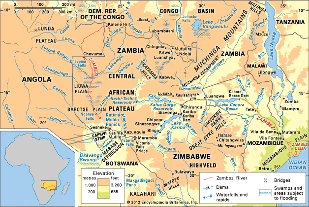
The Zambezi River, the fourth largest river basin in Africa, flows approximately 2,200 miles from the Central African Plateau to the Indian Ocean. Its course is defined by several significant natural and man-made landmarks:1
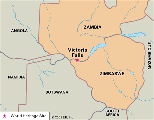
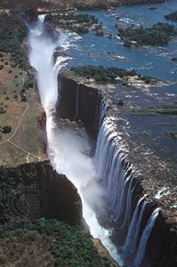
- Upper Course: Rising near Kalene Hill, Zambia, the river flows through the Barotse Plain and over the Chavuma and Ngonye Falls. It eventually reaches Victoria Falls, a World Heritage site and one of the world’s greatest natural wonders, where the river plunges into a narrow chasm.213
- Middle Course: This stretch features two of Africa’s largest hydroelectric projects: Lake Kariba and Lake Cahora Bassa. The river here is characterized by deep gorges and is joined by major tributaries, including the Kafue River and the Luangwa River.12
- Lower Course: After passing through the Lupata Gorge, the river enters the Mozambique Plain, eventually reaching the Indian Ocean through a wide, marshy delta obstructed by sandbars.2
What are some of the most notable species of fish found in the Zambezi River?
The Zambezi River supports a variety of fish species, some of which are distributed across different sections of the river, while others are localized. Notable species include:
- Tiger fish: One of the few species found both above and below the Victoria Falls.6
- Bream: These are now common throughout the river, both above and below the falls.6
- Pike: Predominant in the upper course of the river.6
- Yellowfish and Barbel: Also found in the upper course of the river.6
- Kapenta: A type of freshwater sardine introduced to Lake Kariba from Lake Tanganyika, where it is a well-established fishery.7
Additionally, the cichlid family is highly diverse in African waters, with many species exhibiting complex behaviors such as mouthbreeding.8
What are the major tributaries of the Zambezi River?
The Zambezi River is fed by numerous tributaries throughout its 2,200-mile course. These waterways are essential to the river’s drainage basin, which covers more than 500,000 square miles.1
Key tributaries include:
- Kafue River: Rising on the Copperbelt, this is the Zambezi’s largest tributary. It drains the Lukanga Swamp and the Kafue Flats before descending to join the Zambezi near Chirundu.9210
- Luangwa River: A significant tributary that flows through a rift trough and joins the Zambezi in the middle course.29
- Kabompo River: Intersects the Zambezi along the floodplains in the upper course from the east.9
- Lungué-Bungo (Lungwebungo) River: A larger tributary that joins the Zambezi from the west in the upper course.9
- Cuando (Kwando) River: Joins the Zambezi after the river meanders through the grasslands of the Sesheke Plain.9
- Shire River: The river’s last great tributary, which drains Lake Nyasa and joins the Zambezi near Vila Fontes in the lower course.9
What is the Zambezi River and where is it located in Africa?
The Zambezi River is a major waterway in south-central Africa, representing the continent’s fourth-largest river basin. Its name, which translates to “Great River” in the language of the Tonga people, reflects its significance to the region.1
The river originates from a marshy bog near Kalene Hill in Zambia and flows eastward for approximately 2,200 miles (3,540 kilometers) before emptying into the Indian Ocean. Throughout its journey, the Zambezi crosses or defines the borders of six countries: Angola, Zambia, Namibia, Botswana, Zimbabwe, and Mozambique.12
The river is characterized by diverse landscapes, including the expansive Barotse floodplains, the iconic Victoria Falls, and major hydroelectric projects like the Kariba and Cahora Bassa dams. Its drainage basin spans more than 500,000 square miles, playing a vital role in the geography and ecology of the region.12
Sources
- Zambezi River — Encyclopædia Britannica
- Zambezi River - Physiography — Encyclopædia Britannica
- Victoria Falls — Encyclopædia Britannica
- Zambia - Plant and animal life — Encyclopædia Britannica
- Zimbabwe - Plant and animal life — Encyclopædia Britannica
- Zambezi River - Animal life — Encyclopædia Britannica
- Zambia - Fishing — Encyclopædia Britannica
- cichlid — Encyclopædia Britannica
- Zambia - Drainage — Encyclopædia Britannica
- Kafue River — Encyclopædia Britannica
- Zambezi River - Climate of the Zambezi River — Encyclopædia Britannica
Published on · 3 min read