Karl Marx Peak
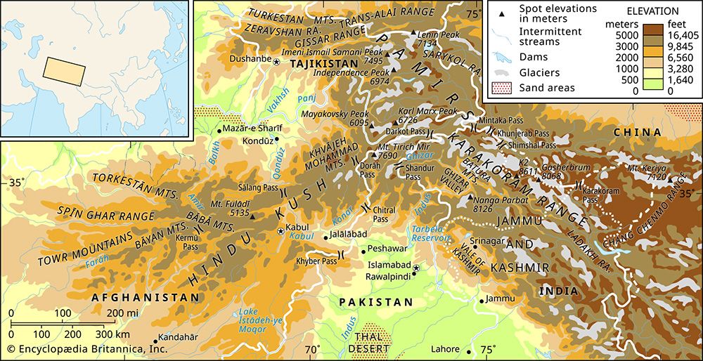
Karl Marx Peak is a prominent mountain located in the southwestern Pamirs within the Gorno-Badakhshan province of Tajikistan.
What is Karl Marx Peak?
Karl Marx Peak is a prominent mountain located in the southwestern Pamirs within the Gorno-Badakhshan province of Tajikistan.1
Standing at an elevation of 22,067 feet (6,726 meters), it serves as the highest summit of the Shakhdarin Mountains, a range situated between the Shakhdara and Panj river valleys. The peak holds historical significance in mountaineering, having been first ascended by Soviet alpinists in September 1946 via the Shakhdara valley.1
What are the Pamir Mountains known for?
The Pamir Mountains are a vast, high-altitude region in Central Asia primarily located within Tajikistan, with fringes extending into Afghanistan, China, and Kyrgyzstan. They are known for several distinct characteristics:2
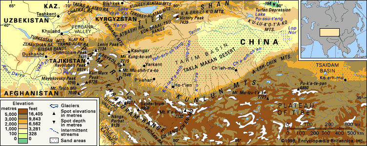
- The Pamir Knot: The region centers on a massive orogenic uplift known as the “Pamir Knot,” from which several major mountain ranges radiate, including the Hindu Kush, Karakoram Range, Kunlun Mountains, and Tien Shan.2
- Physiography: The region is divided into two distinct areas. The eastern Pamirs feature high-altitude, undulating grasslands (the word pamir denotes these high pastures) with rounded contours and wide valleys. The western Pamirs are characterized by high, sharply disjointed alpine ridges, deep ravines, and extensive glaciation, including the Fedchenko Glacier.234
- Historical Significance: The mountains were crossed by branches of the Silk Road and served as a strategic buffer zone between the Russian and British empires during the 19th century.4
- Biodiversity: The high tablelands are a vital habitat for wildlife, including the argali (Marco Polo) wild sheep, ibex, and the snow leopard.5
How do mountain climbers prepare for high-altitude peaks?
To prepare for high-altitude peaks, climbers must address the extreme physiological challenges posed by low oxygen levels, known as hypoxia, and the risk of altitude sickness.89
Acclimatization Strategies
The primary method for adapting to thin air is a gradual process of acclimatization, which allows the body to adjust to lower atmospheric pressure.109
- Climb High, Sleep Low: In “siege” style climbing, teams establish a series of camps at increasing elevations. Climbers ascend to set up higher camps but return to lower altitudes to sleep, which helps the body adapt to the environment.11
- Time Commitment: Even in lightweight “Alpine” style expeditions, climbers typically spend at least four weeks at or near Base Camp to acclimatize before attempting a summit.11
Medical and Physiological Preparation
- Prophylactic Medication: Some climbers use the diuretic acetazolamide, starting it two to three days before ascent to help prevent or mitigate symptoms.9
- Physiological Response: The body naturally attempts to compensate for oxygen scarcity by increasing ventilation (deeper breathing) and producing more hemoglobin and red blood cells to improve oxygen transport.10
- Emergency Planning: Climbers must be prepared for severe conditions like high-altitude pulmonary edema (HAPE) or cerebral edema (HACE). The most effective treatment is immediate descent to a lower elevation, though dexamethasone can be used as emergency first aid to help an incapacitated climber regain the ability to move.89
What is the geography of Tajikistan like?
Tajikistan is a landlocked, predominantly mountainous country in Central Asia, with more than nine-tenths of its territory defined by rugged terrain. Approximately half of the nation lies at an elevation of 10,000 feet (3,000 meters) or higher.12
Relief and Topography
The country’s landscape is dominated by several major mountain systems:
- Pamir Mountains: Located in the southeast, this system contains some of Central Asia’s highest peaks, including Imeni Ismail Samani Peak (24,590 feet) and Ibn Sīnā Peak (23,406 feet).12
- Tien Shan System: The Trans-Alay range extends into the north, while the Turkestan, Zeravshan, and Gissar ranges define the east-central region.12
- Valleys: Though they occupy less than one-tenth of the land, valleys like the Fergana Valley are vital for human settlement and agriculture.12
Climate and Drainage
The climate is sharply continental and varies significantly with altitude, ranging from hot, dry summers in the valleys to extreme cold in the high Pamirs. The country features a dense river network, including the Syr Darya and Amu Darya, which are fed by seasonal snowmelt and glaciers.132
Seismic Activity
Tajikistan lies within an active seismic belt, making severe earthquakes a frequent and significant environmental hazard.12
Sources
- Karl Marx Peak — Encyclopædia Britannica
- Pamirs — Encyclopædia Britannica
- Pamirs - Physiography — Encyclopædia Britannica
- Pamirs - Climate — Encyclopædia Britannica
- Pamirs - Study and exploration — Encyclopædia Britannica
- Pamirs - Plant life — Encyclopædia Britannica
- Pamirs - Animal life — Encyclopædia Britannica
- Mount Everest - The human challenge — Encyclopædia Britannica
- human respiratory system - High altitudes — Encyclopædia Britannica
- Mount Everest - Routes and techniques — Encyclopædia Britannica
- altitude sickness — Encyclopædia Britannica
- Tajikistan - Relief — Encyclopædia Britannica
- Tajikistan - Drainage and soils — Encyclopædia Britannica
- Tajikistan - Climate — Encyclopædia Britannica
- Tajikistan - Settlement patterns — Encyclopædia Britannica
- Turkistan Range — Encyclopædia Britannica
- Zeravshan Range — Encyclopædia Britannica
Published on · 3 min read