Khan Tängiri Peak
Khan Tängiri Peak (also known as Khan-Tengri) is a prominent mountain located in the Tien Shan range of Central Asia. Situated within a heavily glaciated…
What is Khan Tängiri Peak?
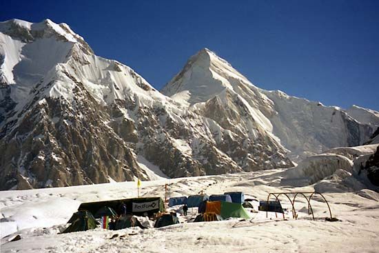
Khan Tängiri Peak (also known as Khan-Tengri) is a prominent mountain located in the Tien Shan range of Central Asia. Situated within a heavily glaciated mountain knot, the peak stands at an elevation of 22,949 feet (6,995 meters).123
The mountain is geographically significant as it sits at the juncture of the borders between Kazakhstan, Kyrgyzstan, and the Xinjiang region of China. It holds the distinction of being the highest point in Kazakhstan. While it was historically believed to be the highest peak in the entire Tien Shan system, it was later determined that the nearby Victory Peak (Jengish Chokusu) is taller, reaching 24,406 feet (7,439 meters). Additionally, the Kalagyuri Glacier, located to the east of the peak, is recognized as the largest known glacier in China.142
What is the significance of the Tian Shan mountain range?
The Tien Shan, or “Celestial Mountains,” is a vast mountain system in Central Asia that holds significant geographical, climatic, and historical importance. Stretching approximately 1,500 miles, it serves as a major physical barrier that shapes the environment and human history of the region.5
Geographical and Climatic Significance
The range acts as a critical climatic barrier, isolating the interior tablelands of Central Asia from moisture-laden winds. This creates a “rain shadow” effect, resulting in extreme aridity in surrounding basins while fostering diverse elevation-based climatic zones within the mountains themselves. The system is also geologically active, characterized by deep faults and significant seismic activity.678
Historical and Cultural Importance
The Tien Shan has long been a crossroads for civilization:
- The Silk Road: Historically, the Silk Road followed the southern edge of the range, facilitating trade and cultural exchange between China and Southwest Asia. Today, the “Silk Roads: the Routes Network of Chang’an-Tianshan Corridor” is recognized as a World Heritage site.910
- Cultural Heritage: The region is home to diverse ethnic groups, including the Uyghur, Kazakhs, and Mongolians, whose traditions and pastoral lifestyles are deeply connected to the mountain landscape.11
How do glaciers like the Kalagyuri Glacier shape mountain landscapes?
Glaciers like the Kalagyuri Glacier act as powerful agents of landscape transformation through processes of erosion and deposition.
Erosional Processes
Glaciers reshape mountainous terrain by drastically altering existing river valleys. While rivers typically carve narrow, V-shaped valleys, glaciers remove loose debris and erode the bedrock along the base and lower sidewalls, transforming them into characteristic U-shaped valleys with steep, often vertical sides.13
At the heads of these valleys, glaciers form cirques—amphitheatre-shaped hollows created by ice wedging and glacial scouring. When multiple cirques erode a mountain from different sides, they leave behind sharp, knife-edge ridges known as arêtes and jagged, pyramid-like peaks called horns.13
Depositional Processes
As glaciers move, they transport vast amounts of rock debris, which is deposited as till to form moraines. These ridges of debris mark the glacier’s margins and positions during periods of advance or retreat. Additionally, meltwater streams flowing from the glacier transport and rework sediment, creating extensive glaciofluvial deposits in the valleys below.1415
What is the difference between Khan Tengri and Victory Peak?
Khan Tängiri Peak and Victory Peak are both prominent mountains located within a central cluster of the Tien Shan range, but they differ significantly in elevation and status:
- Elevation: Victory Peak (also known as Jengish Chokusu or Pik Pobedy) is the highest mountain in the entire Tien Shan range, reaching an elevation of 24,406 feet (7,439 metres). Khan Tängiri Peak reaches 22,949 feet (6,995 metres).1518
- Significance: While Khan Tängiri was historically thought to be the highest point in the Tien Shan, it is now recognized as the highest point in [Kazakhstan]1. Victory Peak is located on the border of [Kyrgyzstan].518
Both peaks are situated in a heavily glaciated region where ridges extend along the boundaries between China, Kyrgyzstan, and Kazakhstan.15
Sources
- Khan Tängiri Peak — Encyclopædia Britannica
- Khan-Tengri — Merriam-Webster
- Kazakhstan - Relief — Encyclopædia Britannica
- Tien Shan - Physiography — Encyclopædia Britannica
- Tien Shan — Encyclopædia Britannica
- Tien Shan - Geology of Tien Shan — Encyclopædia Britannica
- Tien Shan - Climate — Encyclopædia Britannica
- list of World Heritage sites - Kyrgyzstan — Encyclopædia Britannica
- Asia - The influence of topography — Encyclopædia Britannica
- Xinjiang - Cultural life — Encyclopædia Britannica
- Tien Shan - Study and exploration — Encyclopædia Britannica
- Tian Shan — Merriam-Webster
- glacial landform - Cirques , tarns, U-shaped valleys, arêtes, and horns — Encyclopædia Britannica
- glacial landform - Moraines — Encyclopædia Britannica
- Alps - Geology — Encyclopædia Britannica
- glacial landform - Meltwater deposits — Encyclopædia Britannica
- Pleistocene Epoch - Fluvial environments — Encyclopædia Britannica
- Xinjiang - Relief — Encyclopædia Britannica
Published on · 3 min read