Lesser Antilles
The Lesser Antilles are a long, crescent-shaped arc of small islands located in the Caribbean Sea. Geographically, they extend in a north-south direction…
What is the geographical location and extent of the Lesser Antilles?
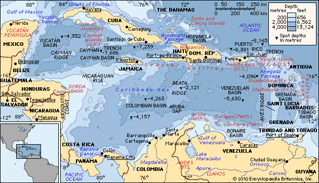
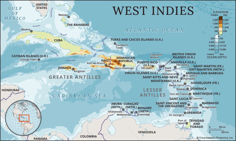
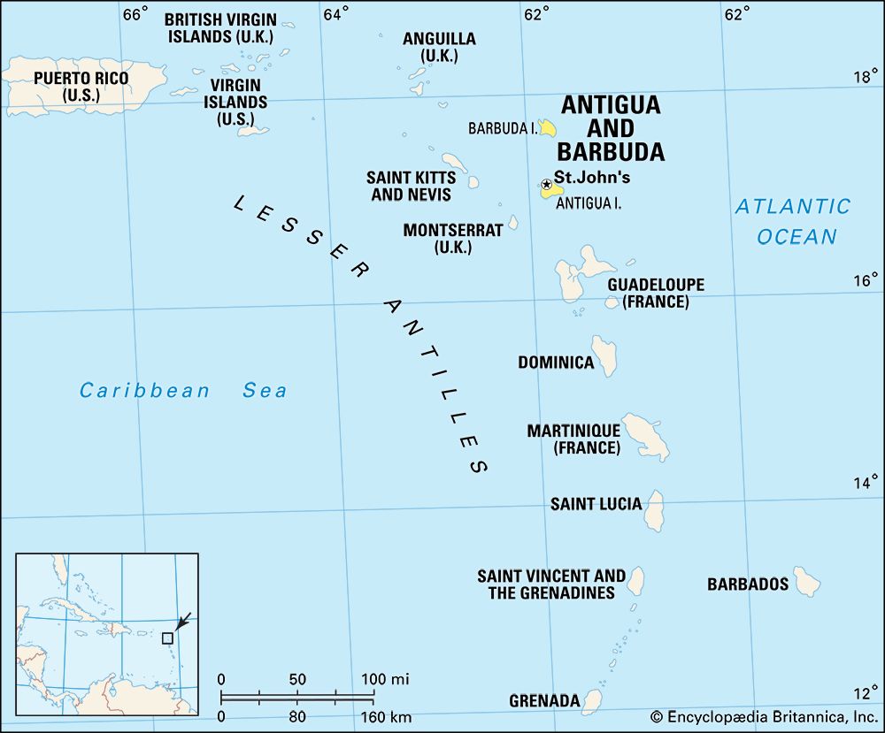
The Lesser Antilles are a long, crescent-shaped arc of small islands located in the Caribbean Sea. Geographically, they extend in a north-south direction from the Virgin Islands in the north to Grenada in the south.12
The region is physiographically divided into two main arcs:
- Inner Arc: A mountainous chain of volcanic islands stretching from Saint Kitts to Grenada, featuring some active volcanic cones.2
- Outer Arc: A chain of lower, flatter islands composed of limestone, extending from Anguilla to Barbados.2
Additionally, an east-west chain of islands—including Aruba, Curaçao, and Bonaire—lies off the northern coast of Venezuela. While these are situated on the South American continental shelf, they are typically included in the definition of the Lesser Antilles.12
How were the Lesser Antilles formed, and what is their geological significance?
The Lesser Antilles were formed through complex tectonic processes involving the convergence of lithospheric plates. Their creation is primarily attributed to the continued subduction of the central Atlantic lithosphere beneath the eastern edge of the Caribbean Plate.13
Geological Formation
As an island arc, the Lesser Antilles represent a zone where the floor of the North Atlantic Ocean underthrusts the Caribbean Plate. This process, known as subduction, forces the denser oceanic crust downward into the Earth’s mantle. As the descending plate reaches high temperatures and pressures, it undergoes partial melting, generating magma that rises to the surface to form the volcanic islands characteristic of the arc. This tectonic activity has been ongoing for tens of millions of years, with the Caribbean Plate moving eastward relative to North and South America at a rate of 10 to 20 millimeters per year.34
Geological Significance
The Lesser Antilles are geologically significant for several reasons:
- Volcanic Activity: The arc serves as a prime example of an active volcanic system, where the extrusion of basalts and andesites continues to shape the islands.34
- Tectonic Indicators: They provide critical evidence of the dynamic interactions between the Caribbean, North American, and South American plates, marking a boundary where crustal deformation and seismic events are frequent.34
- Structural Complexity: The region illustrates the classic features of an island arc, including associated deep-sea trenches and the presence of both volcanic and non-volcanic island chains, which reflect the underlying history of plate convergence and sediment accumulation.54
How has colonialism shaped the history and development of the Lesser Antilles?
Colonialism profoundly shaped the history and development of the Lesser Antilles, leaving an enduring legacy on their social, economic, and political structures.
Colonial Expansion and Conflict
During the 17th century, the Lesser Antilles became a primary focus for European powers—specifically England, France, and the Netherlands—due to their perceived vulnerability and lack of strong Spanish defense. These powers established colonies for strategic and agricultural purposes, leading to centuries of territorial disputes and shifting administrative control.78
Economic and Social Impact
The development of plantation agriculture, particularly for sugar, fundamentally altered the region’s ecology and demographics. Enslaved Africans were brought to the islands in massive numbers to labor under brutal conditions, creating societies deeply fragmented by class and skin color. This history of exploitation resulted in significant environmental degradation, such as deforestation and soil erosion, while establishing economic systems heavily reliant on foreign capital and primary commodity exports.910
Modern Challenges and Dependency
Following decolonization, many islands transitioned to independent states or maintained ties with former powers. However, neocolonialism remains a significant challenge; many island economies continue to depend on foreign enterprise, trade, and aid. While democratization has largely succeeded, these nations continue to navigate the complexities of self-determination and the pursuit of sustainable, grassroots economic development.108
What are the main island groups that make up the Lesser Antilles?
The Lesser Antilles are traditionally organized into three main groups based on their geographic position and the influence of the prevailing trade winds:1
- Leeward Islands: This group forms the northern part of the arc, extending from the Virgin Islands to Guadeloupe.1
- Windward Islands: These islands range south from Dominica to Grenada.1
- Leeward Antilles: This east-west chain is located close to the northern coast of Venezuela and includes islands such as Aruba and Margarita Island. While these islands are physiographically part of the South American continental shelf, they are commonly included in the definition of the Lesser Antilles.1
The distinction between the Windward and Leeward groups historically reflects the importance of the easterly trade winds, which drop their moisture on the Windward islands, leaving the Leeward Antilles relatively arid.1
Sources
- Lesser Antilles — Encyclopædia Britannica
- West Indies — Encyclopædia Britannica
- North America - 120 to 30 million years ago — Encyclopædia Britannica
- Caribbean Sea - Geology — Encyclopædia Britannica
- mountain - The Caribbean chains — Encyclopædia Britannica
- island arc — Encyclopædia Britannica
- West Indies - Colonialism of the West Indies — Encyclopædia Britannica
- Saint Vincent and the Grenadines - Independence of Saint Vincent and the Grenadines — Encyclopædia Britannica
- Haiti - Plantations and enslaved people — Encyclopædia Britannica
- West Indies - Dependency — Encyclopædia Britannica
- Leeward Islands — Encyclopædia Britannica
Published on · 4 min read