Curaçao
Curaçao’s economy has historically relied on its strategic location in the southern Caribbean and its deep natural harbor, which facilitated its development…
What are the main economic activities and industries on the island of Curaçao?
Curaçao’s economy has historically relied on its strategic location in the southern Caribbean and its deep natural harbor, which facilitated its development as a major commercial and maritime hub.12
The island’s primary economic activities and industries include:
- Tourism: A major driver of the modern economy, attracting visitors to the island.12
- International Trade and Logistics: The island remains a significant center for shipping, port services, and entrepôt trade, supported by its extensive harbor facilities.132
- Financial Services: Willemstad serves as an important regional center for banking and commerce.32
- Petroleum Industry: Historically, oil refining and transshipment were central to the economy, particularly following the exploitation of Venezuelan oil fields in the early 20th century. While this sector declined significantly following the 2019 closure of the Isla refinery, the island maintains infrastructure for bunkering and storage.32
- Specialized Production: Curaçao produces its namesake liqueur from local oranges and exports aloes for pharmaceutical use.32
Other sectors, such as agriculture, fishing, and mining, play only minor roles due to the island’s dry climate and limited fertile soil.32
How did Curaçao’s history as a Dutch colony shape its culture and language?
Curaçao’s history as a Dutch colony profoundly shaped its cultural identity and linguistic landscape, primarily through its role as a maritime and commercial hub.
Language Development
The most significant linguistic legacy is the development of Papiamentu, an official language of the island. It emerged after the Dutch seized Curaçao from Spain in 1634. Following the expulsion of Portuguese-speaking Dutch colonists and their Sephardic Jewish allies from Brazil in 1659, they brought a Portuguese vernacular to the island. This base was subsequently modified by enslaved Africans and influenced by Spanish-speaking traders from South America. Today, Papiamentu is a vibrant creole widely used in daily life, media, and education, while Dutch remains the official language for government and education.4531
Cultural and Architectural Legacy
- Sephardic Jewish Heritage: The arrival of Jewish immigrants in the mid-17th century established one of the oldest Jewish communities in the Americas. The Mikvé Israel-Emanuel Synagogue in Willemstad stands as a testament to this enduring history.61
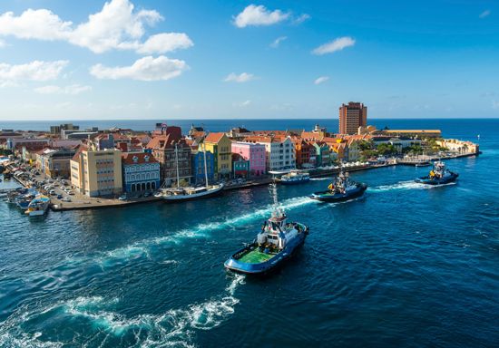
- Architecture: The island features distinctive landhuizen (18th- and 19th-century rural mansions) and Dutch-style colonial architecture in Willemstad, which incorporates tropical adaptations and vibrant pastel colors.1
- Demographics: The colonial economy, centered on the transatlantic slave trade, fundamentally shaped the island’s demographic makeup, resulting in a population primarily of African and mixed African-European heritage.61
What is the geographical location and size of Curaçao?
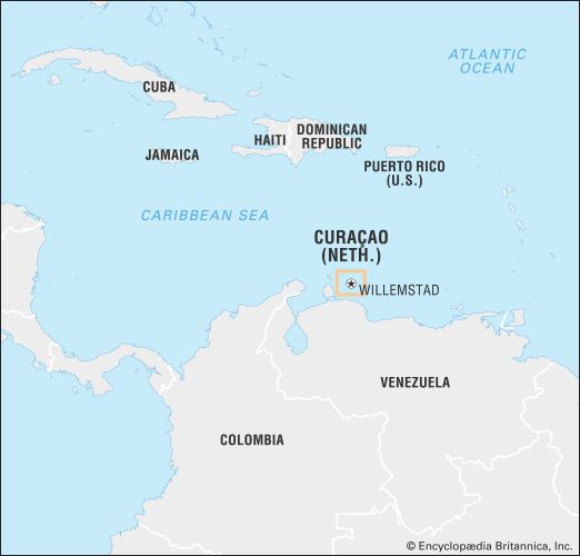
Curaçao is an island country situated in the southern Caribbean Sea, located approximately 37 miles (60 km) north of the coast of Venezuela. While it is physiographically part of the South American continental shelf, it is generally considered to be part of the southwestern arc of the Lesser Antilles.41
Regarding its size, the island has a total land area of 171 square miles.3
What is the significance of Curaçao’s natural harbor, Willemstad?
Willemstad’s natural harbor is a cornerstone of Curaçao’s historical and economic development. Its significance is primarily derived from the unique geography of Sint Anna Bay, a deep channel that provides access to Schottegat, a large, deep, and virtually enclosed bay. This configuration provides one of the finest natural harbors in the West Indies.83
The harbor’s strategic importance has evolved over centuries:
- Maritime Commerce: Following the Dutch seizure of the island in 1634, the harbor became a vital center for maritime trade and shipping, eventually making the island a target for privateers during colonial rivalries.8
- Petroleum Industry: In the 20th century, the harbor’s ability to accommodate large tankers, combined with its location along major shipping routes, transformed Willemstad into a principal Caribbean port for the refining and transshipment of oil from the Maracaibo Basin.8
- Modern Economy: Today, the harbor supports extensive dry-docking, bunkering, and storage facilities, serving as a hub for international trade, tourism, and port services.98
In 1997, the inner city and harbor were designated a UNESCO World Heritage site in recognition of their historical and architectural significance.9
Sources
- Curaçao: Top Questions — Encyclopædia Britannica
- Netherlands Antilles - Economy of Netherlands Antilles — Encyclopædia Britannica
- Curaçao — Encyclopædia Britannica
- Curaçao: Country Facts — Encyclopædia Britannica
- Papiamentu — Encyclopædia Britannica
- Netherlands Antilles - People — Encyclopædia Britannica
- Netherlands Antilles - Curaçao — Encyclopædia Britannica
- Willemstad — Encyclopædia Britannica
- Sint Anna Bay — Encyclopædia Britannica
Published on · 3 min read