Østerdalen
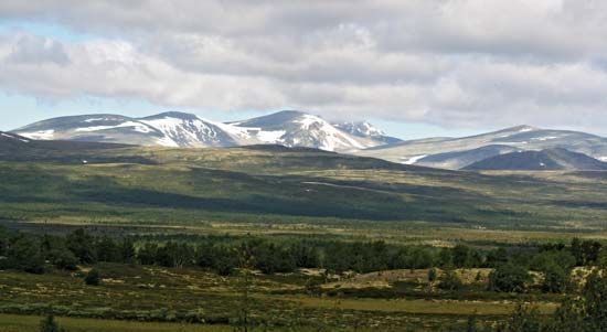
Østerdalen is a narrow valley located in Hedmark county in southeastern Norway. Extending approximately 75 miles (120 km) in a north-south direction, the…
What is Østerdalen?
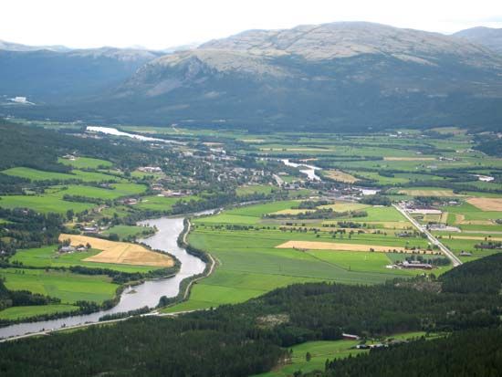
Østerdalen is a narrow valley located in Hedmark county in southeastern Norway. Extending approximately 75 miles (120 km) in a north-south direction, the valley begins at the eastern flanks of the Dovre Mountains.1
The Glomma (Glåma), which is Norway’s longest river, flows through the length of the valley. The region’s economy is primarily driven by lumbering, agriculture—specifically the production of grains and hay—and livestock raising. Industrial activity is also present; for example, the town of Rena, situated at the junction of the Rena and Glomma rivers, hosts paper and cardboard mills supported by hydroelectric power generated from dams on the Glomma. Other notable locations within the valley include the rural municipalities of Tynset and Alvdal, as well as the town of Koppang. Additionally, the area is a popular destination for tourists due to the excellent fishing opportunities in the Glomma.1
What role does the Glomma River play in Norway’s economy?
The Glomma River is a vital component of Norway’s economy, serving as a major resource for industry, energy, and tourism.
Industrial and Energy Contributions
- Timber Industry: The river flows through Norway’s most productive timber forests. It serves as a primary transport route for logs, which are floated downstream to Sarpsborg, a hub for extensive sawmills and paper mills.4
- Hydroelectric Power: The Glomma is a significant source of hydroelectric power. Numerous dams along the river generate electricity that supports local industrial facilities, such as the paper and cardboard mills located in towns like Rena.41
Infrastructure and Tourism
- Navigation: The river is navigable from its mouth at the Oslo Fjord up to the Sarpsfoss (Sarps Falls) in Sarpsborg, facilitating the movement of goods.4
- Tourism: The river is a popular destination for outdoor recreation, particularly for its excellent fishing opportunities, which draw many visitors to the region.1
How did the Ice Age shape the landscape of Norwegian valleys?
During the Quaternary Period’s Great Ice Age, glaciers played a transformative role in shaping Norway’s landscape through intense scouring and erosion.3
- Formation of U-shaped Valleys: Before the Ice Age, rivers had carved V-shaped valleys into the terrain. As glaciers moved through these areas, their immense weight and scouring action widened and deepened them, transforming them into the characteristic U-shaped valleys seen today.36
- Creation of Fjords: On the western coast, these glaciated valleys were eventually submerged by the sea after the ice melted, creating deep, steep-walled fjords. Because glaciers were most active near their source, these valleys were often eroded far below sea level, resulting in the extreme depths observed in many Norwegian fjords.36
- Sediment Transport: Glacial movement acted as a massive conveyor, transporting enormous quantities of soil, gravel, and stone as far south as present-day Denmark and Germany. This process also scoured and polished the exposed bedrock, which remains visible across much of the country today.3
What are the main differences between the regions of Østlandet and Vestlandet?
The regions of Østlandet (Eastern Norway) and Vestlandet (Western Norway) are primarily distinguished by their geography, economic focus, and settlement patterns, separated by the Lang Mountains.7
Geographical Differences
- Østlandet: Characterized by broader valleys and a landscape that slopes more gently toward the east. It contains the Oslo Fjord area and significant agricultural districts.78
- Vestlandet: Defined by a rugged, mountainous terrain with steep-walled, narrow fjords that cut deep into the interior. It features Europe’s largest mountain plateau, the Hardanger Plateau, and extensive glaciers like the Jostedals Glacier.37
Economic and Settlement Patterns
- Østlandet: This region holds more than half of Norway’s population, concentrated around the capital, Oslo. It is the center of national wealth, with a heavy concentration of mining, manufacturing, and industrial activity, resulting in the highest average household income in the country.8910
- Vestlandet: Population is concentrated in coastal cities and fishing villages. Major urban centers include Bergen, a historic trade hub, and Stavanger, which serves as the capital of Norway’s oil industry. The economy relies heavily on fishing, shipping, tourism, and petroleum.38
Sources
- Østerdalen — Encyclopædia Britannica
- Lågen — Encyclopædia Britannica
- Norway - Relief — Encyclopædia Britannica
- Glomma — Encyclopædia Britannica
- Lågen — Encyclopædia Britannica
- fjord — Encyclopædia Britannica
- Vestlandet — Encyclopædia Britannica
- Norway - Settlement patterns — Encyclopædia Britannica
- Norway — Encyclopædia Britannica
- Norway - Earliest peoples — Encyclopædia Britannica
- Norway - Manufacturing — Encyclopædia Britannica
- Norway - Soils — Encyclopædia Britannica
Published on · 3 min read