Pará River
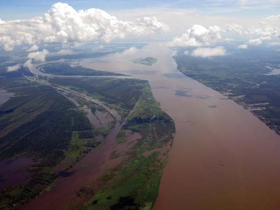
The Pará River is a channel of the Amazon River delta and serves as the estuary for the Tocantins River in northern Brazil. Located in the state of Pará, the…
What is Pará River?
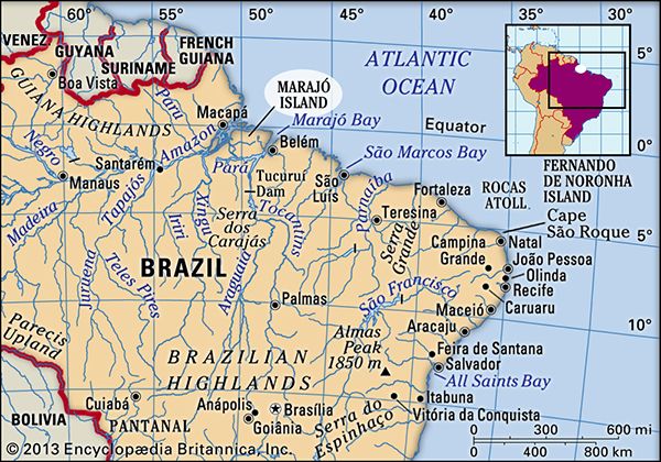
The Pará River is a channel of the Amazon River delta and serves as the estuary for the Tocantins River in northern Brazil. Located in the state of Pará, the river flows to the south and east of Marajó Island.1
Key characteristics of the Pará River include:
- Geography: It spans 200 miles (320 km) in length and varies in width from 5 to 40 miles (8 to 65 km).1
- Navigation: The entire length of the river is navigable.1
- Urban Centers: The city of Belém, the capital of Pará state, is situated on the river’s right bank.1
- Hydrology: It carries a portion of the Amazon River’s discharge toward the Atlantic Ocean and is subject to a strong tidal bore that can reach 12 feet (4 m) in height.1
What is a tidal bore and how does it form?
A tidal bore is a phenomenon occurring in certain rivers and estuaries where an incoming tide rushes upstream as a visible wall of water. This event typically happens during spring tides in areas with a large tidal range where the incoming water is confined to a narrow channel.6
How a Tidal Bore Forms
The formation of a bore involves a dramatic shift in water flow:
- Channel Restriction: As the tide enters a narrow river mouth, the incoming water is forced into a confined space, causing it to travel upstream significantly faster than a normal tidal current.6
- The Wave Front: A well-defined front—often consisting of one or more breaking waves—marks the boundary between the incoming tide and the existing river water. The water surface behind this wave is higher than the water in front of it.6
- Momentum and Collection: The wave travels upstream, collecting the slower-moving or still freshwater in front of it and setting it in motion. Because of this momentum, the bore can continue moving upstream even after the tide has technically reached its peak.6
What is the significance of Marajó Island in the Amazon delta?
Marajó Island is highly significant as the world’s largest fluvial island, formed by sediments deposited by the Amazon River and the Pará River in the state of Pará, Brazil.8
Its key features and significance include:
- Geographic Role: Located at the mouth of the Amazon, the island acts as a major divider in the delta. While the main flow of the Amazon passes to its north, numerous narrow channels (furos) direct water into the Pará River estuary to the south.8
- Ecology and Agriculture: The eastern portion of the island is characterized by savanna landscapes, which support the grazing of water buffalo and cattle. During the annual rainy season, approximately half of the island becomes flooded.8
- Archaeological Importance: The island is noted for containing a large number of archaeological mounds that are rich in elaborate, polychrome pottery, providing insight into the region’s historical human activity.8
- Connectivity: The island serves as a link between the interior and the coast, with the town of Soure acting as a beach resort and ferry hub connecting to the state capital, Belém.8
How does the Tocantins River contribute to the Amazon basin?
The Tocantins River occupies a unique position in relation to the Amazon basin. While it is popularly considered a tributary of the Amazon River, it is technically a separate river system with a drainage basin exceeding 300,000 square miles (800,000 square kilometres).9
Its contribution to the region is primarily through its connection to the Pará River, which serves as a navigable arm of the Amazon delta. The Tocantins flows northward and empties into the Pará River southwest of Belém. Because the Pará River carries a portion of the Amazon’s discharge to the Atlantic Ocean, the Tocantins is integrated into the broader estuarine system that defines the Amazon’s mouth.9110
Additionally, the Tocantins is classified as a blackwater river, characterized by high levels of humic acids and a lack of significant silt or dissolved solids, distinguishing it from the sediment-heavy “whitewater” tributaries that originate in the Andes.10
Sources
- Pará River — Encyclopædia Britannica
- Paru River — Encyclopædia Britannica
- Paranaíba River — Encyclopædia Britannica
- Pará — Encyclopædia Britannica
- Paraguay River — Encyclopædia Britannica
- tidal bore — Encyclopædia Britannica
- tidal bore — Merriam-Webster
- Marajó Island — Encyclopædia Britannica
- Tocantins River — Encyclopædia Britannica
- Amazon River - Physiography of the river course — Encyclopædia Britannica
Published on · 3 min read