Red Sea
The Red Sea region is characterized by an arid climate with minimal precipitation. Its location and physical geography significantly influence local weather…
How does the Red Sea’s location affect weather patterns in the surrounding regions?
The Red Sea region is characterized by an arid climate with minimal precipitation. Its location and physical geography significantly influence local weather patterns through wind systems and high evaporation rates.12
Wind Patterns
Prevailing winds are dictated by the sea’s orientation and latitude:
- Northern Region: North to northwest winds dominate, though winter months occasionally experience violent westerly “Egyptian” winds, which bring fog and blowing sand.1
- Central Region: Winds are variable between 14° and 16° N, though strong northwest winds frequently extend southward during the summer months (June through August).1
- Southern Region: South of 14° N, the prevailing winds shift to a south to southeast direction.1
Temperature and Humidity
The sea’s location contributes to extreme seasonal temperature variations. While fall, winter, and spring are generally mild (46–82 °F), summer temperatures can reach 104 °F. During these warmer months, high relative humidity levels make the region uncomfortable for vigorous outdoor activity. Additionally, the sea experiences significant evaporation—exceeding 80 inches per year—which is a critical factor in its unique hydrological circulation.12
How has the Red Sea been important historically for trade and cultural exchange?
The Red Sea has served as a vital maritime corridor for millennia, functioning as one of the earliest large bodies of water documented in recorded history. Its strategic position has long facilitated essential trade and cultural exchange between the Mediterranean world, Africa, and Asia.3
Historical Significance
- Early Commerce: By 2000 BCE, the Red Sea was a hub for Egyptian maritime commerce. By 1000 BCE, it was established as a primary water route connecting to India.3
- Exploration: The sea was well-charted by 1500 BCE, notably when Queen Hatshepsut of Egypt navigated its length. Later, around 600 BCE, the Phoenicians explored its shores during their circumnavigation of Africa.3
- Canal Development: To enhance connectivity, various shallow canals were constructed between the Nile River and the Red Sea as early as 1850 BCE. These efforts culminated in the 1869 completion of the Suez Canal, which transformed the region into a critical artery for global trade.453
Today, the Red Sea remains one of the world’s most heavily traveled waterways, linking Europe and Asia through essential shipping lanes.67
What are some of the major geological features of the Red Sea, such as the Great Rift Valley?
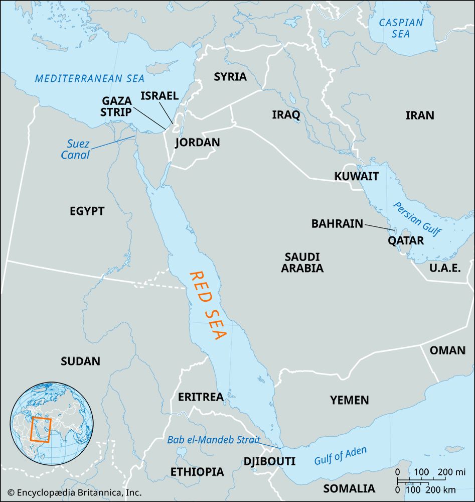
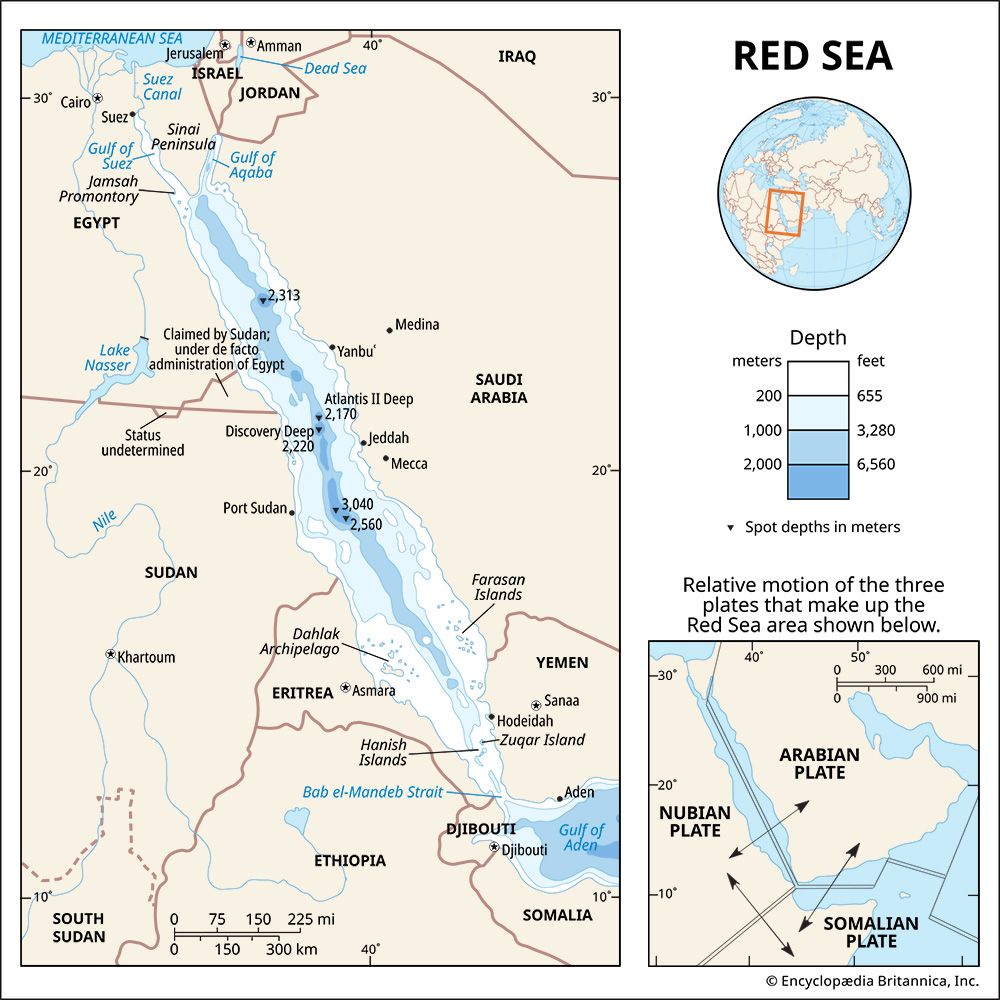
The Red Sea is a geologically active region formed by the separation of the African and Arabian tectonic plates. It occupies a segment of a vast rift system that includes the East African Rift System, extending from the Gulf of Aden in the south to the Wadi Aqaba–Dead Sea–Jordan Rift in the north.8
Key Geological Features
- Tectonic Origin: The sea lies in a fault-bounded depression created by crustal divergence. This process began approximately 55 million years ago, with the Gulf of Suez and the northern Red Sea opening in subsequent phases.89
- Submarine Morphology: The seafloor is characterized by a main trough reaching depths of 4,000 feet. At its northern end, the sea splits into the shallow Gulf of Suez and the much deeper Gulf of Aqaba, which reaches 5,500 feet.10
- Unique Deeps: Within the trough, there are rugged clefts containing hot brine pools and deposits of heavy metal oxides.10
- Ongoing Activity: The region remains tectonically active, evidenced by seismic events, recent volcanism, and a continuous spreading rate of approximately 0.59 to 0.62 inches per year.810
We could dive deeper into the Arabian-Nubian Massif or the specific volcanic activity found in the region.
How did the Red Sea get its name and what are its unique characteristics?
The Red Sea derives its name from the periodic appearance of extensive blooms of the algae Trichodesmium erythraeum. While the water is typically an intense blue-green, these algae turn the sea a reddish-brown color when they die off.3
The Red Sea is defined by several unique characteristics:
- Extreme Hydrology: It contains some of the world’s hottest and saltiest seawater. Because no rivers flow into it and rainfall is minimal, the sea relies on an inflow from the Bab el-Mandeb Strait to compensate for high evaporation rates.39
- Hot Brine Pools: In its deepest troughs, the sea features unique pools of hot, oxygen-free brine. For instance, the Atlantis II Deep reaches temperatures of nearly 140 °F (60 °C) with a salinity level of 257 parts per thousand.9
- Submarine Morphology: The seafloor is marked by rugged clefts and deep troughs, some reaching nearly 10,000 feet. These areas contain rare sediments, including deposits of heavy metal oxides.32
- Tectonic Activity: The sea is a geologically active fault depression, characterized by ongoing spreading, seismic events, and volcanic activity.2
Sources
- Red Sea - Climate — Encyclopædia Britannica
- Red Sea - Hydrology — Encyclopædia Britannica
- Red Sea — Encyclopædia Britannica
- Suez Canal: Top Questions — Encyclopædia Britannica
- canals and inland waterways - The Suez Canal — Encyclopædia Britannica
- Red Sea - Study and exploration — Encyclopædia Britannica
- Arabian Sea - Transportation — Encyclopædia Britannica
- Red Sea - Geology — Encyclopædia Britannica
- Red Sea - Physiography and submarine morphology — Encyclopædia Britannica
- Africa - Formation of the Red Sea — Encyclopædia Britannica
Published on · 4 min read