Saint Helena
Saint Helena is a remote island and British overseas territory located in the South Atlantic Ocean. It is situated approximately 1,200 miles (1,950 km) west…
What is the geographical location and size of Saint Helena in the Atlantic Ocean?
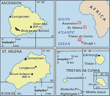
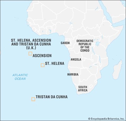
Saint Helena is a remote island and British overseas territory located in the South Atlantic Ocean. It is situated approximately 1,200 miles (1,950 km) west of the southwestern coast of Africa.1
The island has a total area of 47 square miles (122 square km). In terms of its physical dimensions, it reaches a maximum length of 10.5 miles (17 km) from the southwest to the northeast and a maximum breadth of 6.5 miles (10 km).21
How did Saint Helena become a British Overseas Territory, and what is its current political status?
Saint Helena became a British territory through a series of shifts in colonial control. Although discovered by the Portuguese in 1502, the English East India Company took possession of the island in 1659. Following a brief Dutch occupation in 1673, the East India Company’s ownership was confirmed. The island was placed under the jurisdiction of the British Crown during the exile of Napoleon I (1815–1821), and the Crown formally assumed permanent control in 1834.3
Currently, Saint Helena is a British overseas territory known as Saint Helena, Ascension and Tristan da Cunha. Under its 2009 constitution, executive authority is vested in the British monarch, represented by an appointed governor. The territory shares a governor, attorney general, and court system across its islands, though each maintains a separate legislature. Residents are British citizens, a status granted by the British Overseas Territories Act of 2002.3
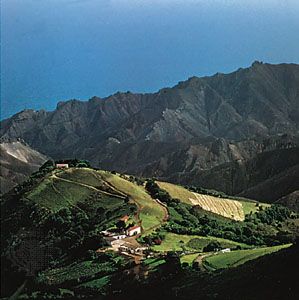
What unique flora and fauna can be found on Saint Helena, and how are they being conserved?
Saint Helena possesses a unique ecosystem that evolved in isolation for millions of years. However, this biodiversity was severely impacted by human arrival in the 16th century and the subsequent introduction of alien species, which continue to threaten the island’s native life.4
Unique Flora and Fauna
The island’s vegetation is categorized into three distinct zones:
- Coastal Zone: A rocky, barren area featuring cacti.
- Middle Zone: Characterized by grassy hillslopes and introduced species like gorse, willows, poplars, and Scotch pines.
- Central Zone: The primary habitat for endemic plants, including the St. Helena ebony, St. Helena redwood, and various black cabbage trees.
Native animal life is generally small in size, consisting primarily of invertebrates such as blushing snails and a diverse array of insects. The island is also home to the wirebird, a species of plover.4
Conservation Status
While the provided information notes that native species have been devastated by human activity and invasive organisms, it does not detail specific ongoing conservation programs or management strategies currently in place to protect these endemic populations.4
What is the climate like on Saint Helena, and how does it affect life on the island?
Saint Helena features a temperate climate influenced by its location in the path of cool South Atlantic trade winds. The island experiences warm summers and winters that are only slightly cooler, maintaining a generally mild environment throughout the year.3
The climate significantly impacts the island’s geography and daily life through variations in rainfall. Precipitation levels are highly dependent on elevation:
- Coastal areas: Experience arid conditions with annual rainfall as low as 8 inches (200 mm).3
- Central regions: Receive significantly more moisture, with annual rainfall exceeding 30 inches (760 mm).3
This climatic variation dictates land use and settlement patterns. Because less than one-third of the island is suitable for agriculture, the distribution of rainfall is a critical factor for the cultivation of crops such as corn, potatoes, and green vegetables. Furthermore, the island’s topography and climate have historically shaped its development, as the limited arable land and reliance on external subsidies have necessitated a small-scale economy and a reliance on maritime connections through the port of Jamestown.3
Sources
- Saint Helena — Merriam-Webster
- Ascension — Encyclopædia Britannica
- Saint Helena — Encyclopædia Britannica
- Mauritius - Plant and animal life — Encyclopædia Britannica
- Netherlands Antilles - Climate — Encyclopædia Britannica
- Sao Tome and Principe - Climate — Encyclopædia Britannica
Published on · 3 min read