Bering Sea and Strait
The climate of the Bering Sea is notably severe, characterized by distinct regional and seasonal variations. While the sea shares latitudes with Great…
What types of weather patterns and seasonal changes occur in the Bering Sea region?
The climate of the Bering Sea is notably severe, characterized by distinct regional and seasonal variations. While the sea shares latitudes with Great Britain, its weather patterns are significantly harsher.1
Regional and Seasonal Variations
- Southern and Western Regions: These areas experience cool, rainy summers with frequent fog. Winters are comparatively warm and snowy, with the southern portion receiving over 40 inches of annual precipitation, primarily as rain.1
- Northern and Eastern Regions: These areas face extreme winter conditions, with temperatures dropping between -31° and -49° F (-35° to -45° C) accompanied by high winds. Summers are cool with low precipitation, which falls mainly as snow.1
Seasonal Dynamics
January and February are the coldest months, while July and August are the warmest. In the north, snow can persist on the coast for up to 10 months. The region also experiences severe storms driven by low atmospheric pressure that occasionally impact the southern sea. Additionally, the northern portion of the sea is covered with ice during the winter, a critical component of the region’s seasonal hydrological cycle.123
Where is the Bering Sea located, and what are its geographical boundaries?
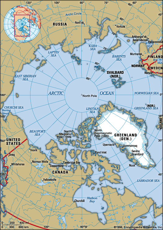
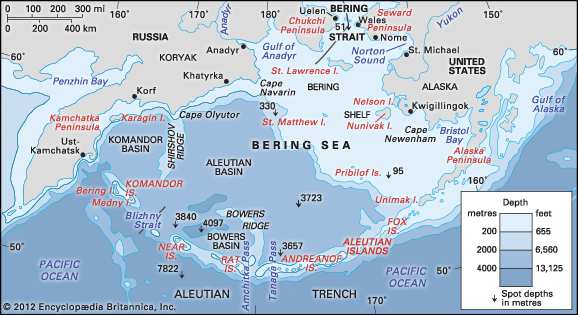
The Bering Sea is the northernmost arm of the Pacific Ocean, situated between the continents of Asia and North America. It serves as a vital maritime connection, linking to the Arctic Ocean through the Bering Strait in the north.4
Geographical Boundaries
The sea is roughly triangular in shape, defined by the following boundaries:
- North: The apex of the triangle, connecting to the Arctic Ocean via the Bering Strait.4
- East: The 1,100-mile-long arc of the Alaska Peninsula.4
- South: The Aleutian Islands, which are part of the U.S. state of Alaska.4
- West: The Komandor (Commander) Islands and the coast of northeastern Siberia.45
The region covers approximately 890,000 square miles, with a boundary between the United States and Russia passing directly through the sea and the strait.4
How have international agreements and disputes shaped the management of the Bering Sea’s resources?
The management of the Bering Sea’s resources has been historically defined by complex international disputes and subsequent cooperative agreements, primarily centered on the conservation of marine life.
The Bering Sea Dispute
In the late 19th century, the United States attempted to assert exclusive control over the Bering Sea to regulate seal hunting. Following the seizure of several Canadian and British vessels, an international tribunal in 1893 ruled that the Bering Sea was part of the high seas, rejecting the U.S. claim of jurisdiction and ordering the U.S. to pay damages.6
Evolution of Cooperative Management
Following the tribunal, nations moved toward collaborative frameworks to manage shared resources:
- North Pacific Sealing Convention (1911): Signed by the United States, Canada, and Japan, this agreement restricted pelagic sealing and established a revenue-sharing model for the annual hunt.6
- Interim Convention (1957): After Japan withdrew from the 1911 convention in 1941, a new interim agreement was established in 1956 involving Canada, the United States, Japan, and the Soviet Union, reflecting a shift toward multilateral cooperation.6
Today, the sea remains a shared space where the boundary between the United States and Russia passes through the water, necessitating ongoing diplomatic attention to resource management and sovereignty.7
What is the significance of the Bering Strait in terms of geography and human migration?
The Bering Strait is a vital geographical feature that separates the continents of Asia and North America, linking the Arctic Ocean to the Bering Sea. At its narrowest point, it spans approximately 53 miles and averages depths between 98 and 164 feet.8
Significance for Human Migration
The strait is central to the history of human migration into the Americas. During the Pleistocene Epoch, specifically during the last glacial maximum, global sea levels dropped by as much as 400 feet due to the accumulation of water in glaciers. This exposure of the seafloor created Beringia, a vast land bridge connecting Siberia to Alaska.98
Between 20,000 and 35,000 years ago, this dryland corridor allowed for the migration of plants, animals, and humans from Asia into North America. While the exact methods of travel—whether by land or coastal boat routes—remain a subject of study, it is widely accepted that the ancestors of modern Indigenous peoples in the Americas crossed this region. As glaciers melted and sea levels rose, the land connection was eventually severed, forming the modern strait.89
Sources
- Bering Sea and Strait - Climate — Encyclopædia Britannica
- Bering Sea and Strait - Hydrology — Encyclopædia Britannica
- sea ice — Encyclopædia Britannica
- Bering Sea and Strait — Encyclopædia Britannica
- Bering Sea — Merriam-Webster
- Bering Sea Dispute — Encyclopædia Britannica
- Arctic - The Arctic in international affairs — Encyclopædia Britannica
- Bering Strait — Encyclopædia Britannica
- Beringia — Encyclopædia Britannica
Published on · 3 min read