Florida Current
The Florida Current is a swift, northward-flowing surface ocean current that travels along the continental slope between the Straits of Florida and Cape…
What is Florida Current?
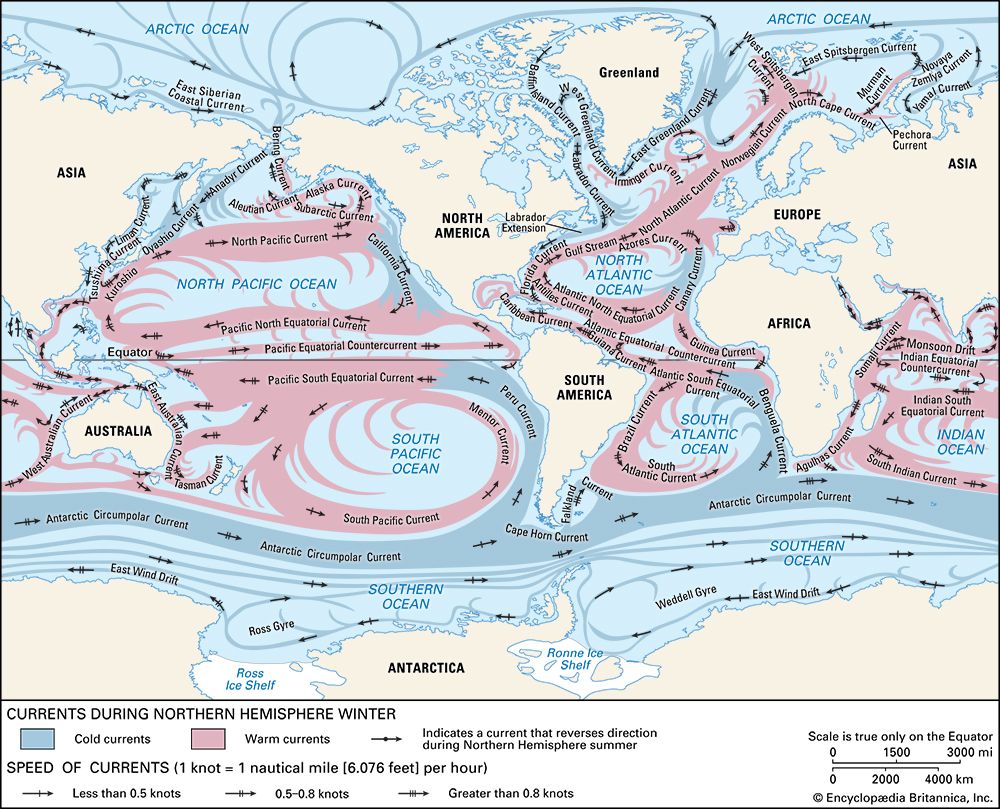
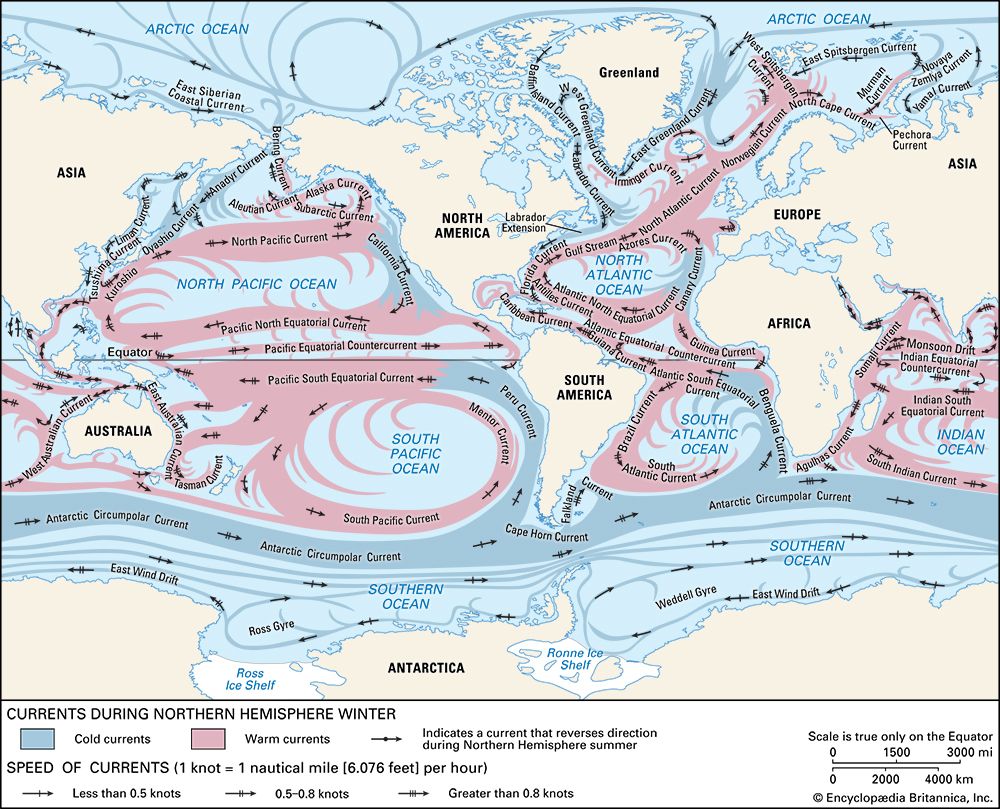
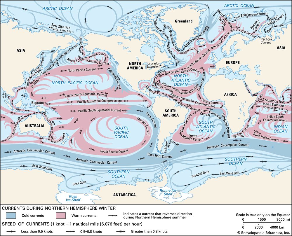
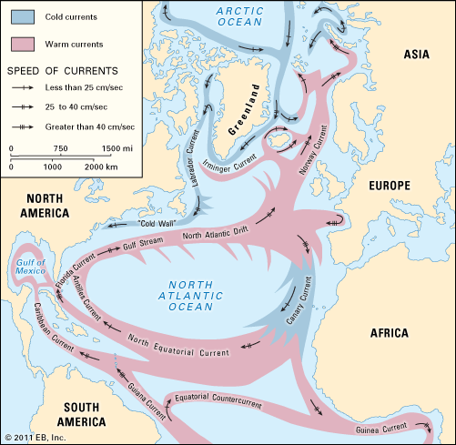
The Florida Current is a swift, northward-flowing surface ocean current that travels along the continental slope between the Straits of Florida and Cape Hatteras.1
Formed as the Caribbean Current exits the Straits of Florida, the current is later joined by the Antilles Current. It is characterized by its high velocity—reaching speeds of more than 3.5 knots in the Straits of Florida—and its significant volume of water transport. While it is a distinct feature, it is also commonly considered a component of the broader Gulf Stream system. The water within the Florida Current is identifiable by its relatively low salinity and temperatures exceeding 44° F (6.5° C).123
How do scientists use satellites to track ocean currents?
Scientists utilize satellites to track ocean currents through several sophisticated remote-sensing techniques that provide a broad, synoptic view of the sea surface.45
Key Satellite Methods
- Radar Altimetry: Satellite-borne radar altimeters measure the precise distance between the satellite and the sea surface. By combining these measurements with orbital data, researchers create maps of sea-surface topography. These maps allow scientists to deduce the surface pressure field and extrapolate the general circulation of the ocean’s upper layers.4
- Radiometry: Satellite-borne infrared and microwave radiometers measure the radiant energy emitted by the ocean to determine sea-surface temperatures. High-resolution infrared imagery is particularly effective for monitoring wave features and tracking time-varying flows in currents like the Gulf Stream.4
- Satellite-Tracked Buoys: In the Lagrangian method of tracking, researchers deploy buoys equipped with radio transmitters. These buoys drift with the current, and their positions are monitored by satellite to provide direct data on surface current movement.6
These satellite-based approaches are essential for overcoming the limitations of ship-based measurements, which are often costly and provide only localized data.45
What is the ‘Cold Wall’ and how does it interact with the Florida Current?
The “Cold Wall” is a distinct oceanographic boundary that separates the warm, saline waters of the Florida Current and the broader Gulf Stream system from the colder, fresher waters overlying the continental shelf along the North American mainland. shelf](https://www.britannica.com/science/continental-shelf) along the North American mainland.2
Interaction with the Florida Current
The Cold Wall serves as the well-defined western margin of the Florida Current. Its interaction with the current is characterized by several key features:
- Temperature and Salinity Gradient: The water within the Florida Current is deep-blue, warm, and highly saline. In contrast, the water on the landward side of the Cold Wall is significantly cooler and has lower salinity, creating a sharp transition zone.1
- Countercurrent Flow: The shelf waters trapped against the Cold Wall often exhibit a southerly flow, which moves in the opposite direction to the northward-flowing Florida Current.1
- Boundary Definition: This boundary is so pronounced that it is easily distinguishable, particularly in winter, when surface temperatures of the Gulf Stream system can be significantly higher than those of the shelf waters only a short distance to the northwest.1
How do ocean currents like the Gulf Stream influence global weather patterns?
Ocean currents like the Gulf Stream are fundamental to regulating global weather and climate patterns by acting as massive heat-transport systems. They move warm water from the tropics toward the poles, significantly moderating the climates of coastal regions.9102
Mechanisms of Influence
- Heat Transfer: The ocean acts as a vast reservoir of heat. Through evaporation and direct heat transfer, currents release energy into the atmosphere, which influences atmospheric circulation.211
- Climate Moderation: The Gulf Stream, in combination with prevailing westerly winds, carries warmth and moisture to northwestern Europe. Without this current, regions like Norway and the British Isles would experience significantly cooler and potentially drier conditions.912
- Storm Development: Warm ocean currents provide the energy necessary for the development of tropical cyclones and extratropical cyclones. Furthermore, the interaction between warm surface waters and cold air masses—such as where the Gulf Stream meets the Labrador Current—creates conditions that lead to high incidences of fog and storm growth.12211
Global Climate Anomalies
Ocean surface temperature anomalies can persist for seasons or years, serving as predictors for climate patterns. For example, the El Niño/Southern Oscillation (ENSO) demonstrates how changes in equatorial ocean temperatures can trigger large-scale atmospheric circulation shifts, affecting weather patterns across the globe.211
Sources
- Florida Current — Encyclopædia Britannica
- Gulf Stream — Encyclopædia Britannica
- Caribbean Current — Encyclopædia Britannica
- undersea exploration - Measurements of ocean currents — Encyclopædia Britannica
- undersea exploration - Acoustic and satellite sensing — Encyclopædia Britannica
- hydrologic sciences - The circulation of the oceans — Encyclopædia Britannica
- hydrologic sciences - Remote sensing of the oceans — Encyclopædia Britannica
- Climate - The Gulf Stream — Encyclopædia Britannica
- How Do Ocean Currents Affect the Biosphere? — Encyclopædia Britannica
- thermohaline circulation — Encyclopædia Britannica
- Climate - Climate and the oceans — Encyclopædia Britannica
- Climate - The ocean surface and climate anomalies — Encyclopædia Britannica
Published on · 3 min read