Gulf of Carpentaria
The Gulf of Carpentaria has a long history of human presence and maritime exploration. While Aboriginal peoples have inhabited the region for at least 40,000…
What is the historical significance of the Gulf of Carpentaria in terms of exploration and settlement?
The Gulf of Carpentaria has a long history of human presence and maritime exploration. While Aboriginal peoples have inhabited the region for at least 40,000 years, European interest began in the early 17th century.12
Exploration
The eastern shore was first explored by the Dutch in 1605, and the southern and western coasts were charted by Abel Tasman in 1644. The gulf was named after Pieter de Carpentier, a governor-general of the Dutch East Indies1. In 1802, the English navigator Matthew Flinders surveyed the western shore, marking a shift toward systematic naval surveying to secure British commercial interests.324
Settlement and Economic Significance
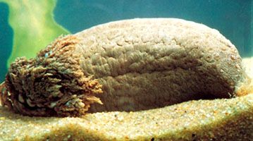
For centuries, the region was largely neglected by European powers, though it saw regular visits from Makasan fishers seeking sea cucumbers. Modern settlement and economic development accelerated significantly in the late 20th century, driven by the exploitation of vast bauxite and manganese deposits, as well as the growth of the prawn fishing industry of the prawn fishing industry. These activities transformed the area, increasing local populations and improving infrastructure and communication links.321
How does the Gulf of Carpentaria impact the climate and weather patterns of northern Australia?
The Gulf of Carpentaria plays a significant role in the weather patterns of northern Australia, particularly through its influence on seasonal climate and extreme weather events.
Seasonal Weather and Flooding
During the summer months (November to April), the region experiences monsoonal rains that profoundly affect the landscape. The combination of these heavy rains, magnified tides, and winds that pile seawater onto the shore leads to the periodic submergence of coastal salt pans. This process causes drainage water to back up in blocked estuaries, resulting in extensive flooding that shapes the transition between bare salt flats and vegetated plains.1
Tropical Cyclones
While the provided information does not detail specific cyclone tracks unique to the Gulf of Carpentaria, it highlights that the formation of tropical cyclones is heavily dependent on the thermal energy of the upper ocean layers. Tropical waters typically require temperatures exceeding 26 °C (about 79 °F) to support cyclone development. Once formed, these storms can significantly impact coastal areas through intense winds, storm surges, and heavy rainfall, eventually dissipating energy upon striking land or moving over cooler waters.6
Where is the Gulf of Carpentaria located and what are its geographical features?
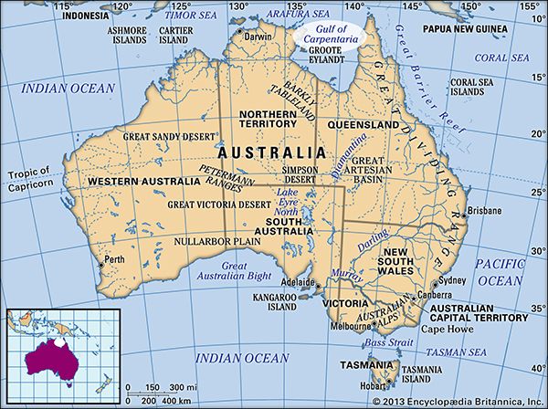
The Gulf of Carpentaria is a shallow, rectangular inlet of the Arafura Sea that indents the northern coast of Australia. It covers an area of 120,000 square miles (310,000 square km) with a maximum depth of 230 feet (70 metres), serving as a rare modern example of an epicontinental sea.1
Geographical Features
- Boundaries: The gulf is enclosed by Arnhem Land to the west and the Cape York Peninsula to the east.1
- Floor: The gulf floor is part of the continental shelf shared by Australia and New Guinea. It is separated from the Coral Sea by a ridge across the Torres Strait.1
- Topography: The surrounding plains, particularly in Queensland, slope gently toward the gulf. The coastline features a belt of salt flats and is fed by more than 20 rivers that form extensive deltas.1
What major rivers flow into the Gulf of Carpentaria?
More than 20 rivers drain into the Gulf of Carpentaria, winding through the landscape and forming extensive deltas as they reach the coast. While many rivers contribute to the region’s hydrology, the Flinders River is specifically noted for its proximity to the widest belt of salt flats along the southeastern shore. Additionally, the Ord River is recognized for its tide-dominated deltaic system in northern Australia, which influences the coastal morphology of the broader region.19
The lowland area surrounding the gulf, known as the Gulf Country, is characterized by being crisscrossed by the distributaries of these numerous rivers, which support local agricultural activities such as cattle breeding.10
Sources
- Gulf of Carpentaria — Encyclopædia Britannica
- Matthew Flinders — Encyclopædia Britannica
- Groote Eylandt — Encyclopædia Britannica
- Northern Territory - Prehistory and European exploration — Encyclopædia Britannica
- Cape York Peninsula — Encyclopædia Britannica
- Climate - Effects of tropical cyclones on ocean waters — Encyclopædia Britannica
- Climate - Conditions associated with cyclone formation — Encyclopædia Britannica
- Carpentaria, Gulf of — Merriam-Webster
- Gulf Country — Encyclopædia Britannica
- coastal landforms - Deltas — Encyclopædia Britannica
Published on · 3 min read