Kara-Bogaz-Gol Gulf
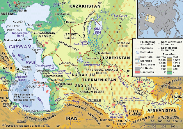
The Kara-Bogaz-Gol Gulf is an inlet located on the eastern side of the Caspian Sea in northwestern Turkmenistan northwestern Turkmenistan. Covering an area…
What is Kara-Bogaz-Gol Gulf?
The Kara-Bogaz-Gol Gulf is an inlet located on the eastern side of the Caspian Sea in northwestern Turkmenistan northwestern Turkmenistan. Covering an area of approximately 4,600 to 5,000 square miles, the gulf is shallow, averaging only 33 feet in depth.1
Due to its location in an arid climate, the gulf experiences intense evaporation, which results in extremely high salinity—reaching up to 350 parts per thousand. To compensate for this water loss, a significant volume of water is continuously drawn into the gulf from the Caspian Sea through a narrow strait.21
Economically, the region is highly significant as it contains the world’s largest deposit of natural marine salts. These deposits, particularly sodium sulfate, are extracted for industrial use and represent a vital resource for the area.13
How does high evaporation affect the salinity of water bodies?
High evaporation significantly increases the salinity of water bodies by removing fresh water while leaving dissolved salts behind. This process is particularly pronounced in arid regions where evaporation rates exceed the input of water from precipitation or river runoff.45267
The impact of evaporation on salinity is further intensified by the following factors:
- Isolation: When a water body, such as a lagoon or a gulf, has limited exchange with the open ocean, the concentration of salts can rise dramatically. In such isolated basins, evaporation can drive salinity to extreme levels, sometimes leading to the precipitation of evaporite minerals.2658
- Density and Circulation: As surface waters lose fresh water to evaporation, they become denser and may sink to the bottom. In some cases, this creates a reverse circulation where seawater flows in at the surface to replace the lost volume, further concentrating the salts within the basin.2
- Climatic Balance: Saline lakes and other inland bodies are highly sensitive to the balance between water input and output. Long-term shifts in climate or human-induced water diversion can disrupt this balance, causing water levels to fall and salinity to rise, which can have severe environmental and economic consequences.74
What are some other major natural resources found in the Caspian Sea region?
The Caspian Sea region is rich in diverse natural resources that play a critical role in the area’s economy. Beyond the mineral deposits found in the Kara-Bogaz-Gol, the most significant resources include:
- Petroleum and Natural Gas: These are the region’s most vital resources. Exploitation began in the 1920s and has expanded significantly, with extensive reserves located under the northeastern Caspian and its surrounding shores. Extraction is conducted via drilling platforms and artificial islands, supported by a growing network of pipelines.3910
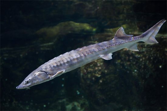
- Fisheries: The sea is historically famous for its sturgeon, which is highly valued for caviar. While populations declined due to environmental changes, the industry remains a key economic component, supported by aquaculture and strict fishing regulations.3
- Seal Industry: In the northern regions of the sea, a seal industry has been developed, primarily focused on the production of furs.3
These resources, along with the region’s strategic importance for transporting goods like grain, cotton, and rice, define the economic landscape of the Caspian basin.10
Why is the Caspian Sea considered an inland sea rather than a lake?
The Caspian Sea is technically classified as the world’s largest salt lake rather than a sea because it is an enclosed inland body of water with no natural connection to the world ocean.11912
While it is often referred to as a “sea” due to its massive size, saline waters, and oceanic-type crustal structures in its southern basin, it does not meet the geographic definition of a sea, which requires a direct connection to the global oceanic system. Historically, the Caspian was linked to the Black Sea and the Mediterranean Sea until approximately 11 million years ago, when geological shifts isolated it. Today, its water levels are determined entirely by the balance between river inflow—primarily from the Volga River—precipitation, and evaporation/Volga-River)—precipitation, and evaporation.1311149
Sources
- Kara-Bogaz-Gol Gulf — Encyclopædia Britannica
- gulf - Factors that affect the characteristics of gulfs — Encyclopædia Britannica
- Caspian Sea - Resources — Encyclopædia Britannica
- sedimentary rock - Deep-basin environment — Encyclopædia Britannica
- lagoon - Water temperature and salinity — Encyclopædia Britannica
- Inland water ecosystem - Saline lakes — Encyclopædia Britannica
- salinity — Encyclopædia Britannica
- seawater - Salinity distribution — Encyclopædia Britannica
- Caspian Sea — Encyclopædia Britannica
- Caspian Sea - Transportation — Encyclopædia Britannica
- Caspian Sea - Geology of the Caspian Sea — Encyclopædia Britannica
- Caspian Sea — Merriam-Webster
- Caspian Sea - Hydrology — Encyclopædia Britannica
- Caspian Sea: Top Questions — Encyclopædia Britannica
Published on · 3 min read