Laurentide Ice Sheet
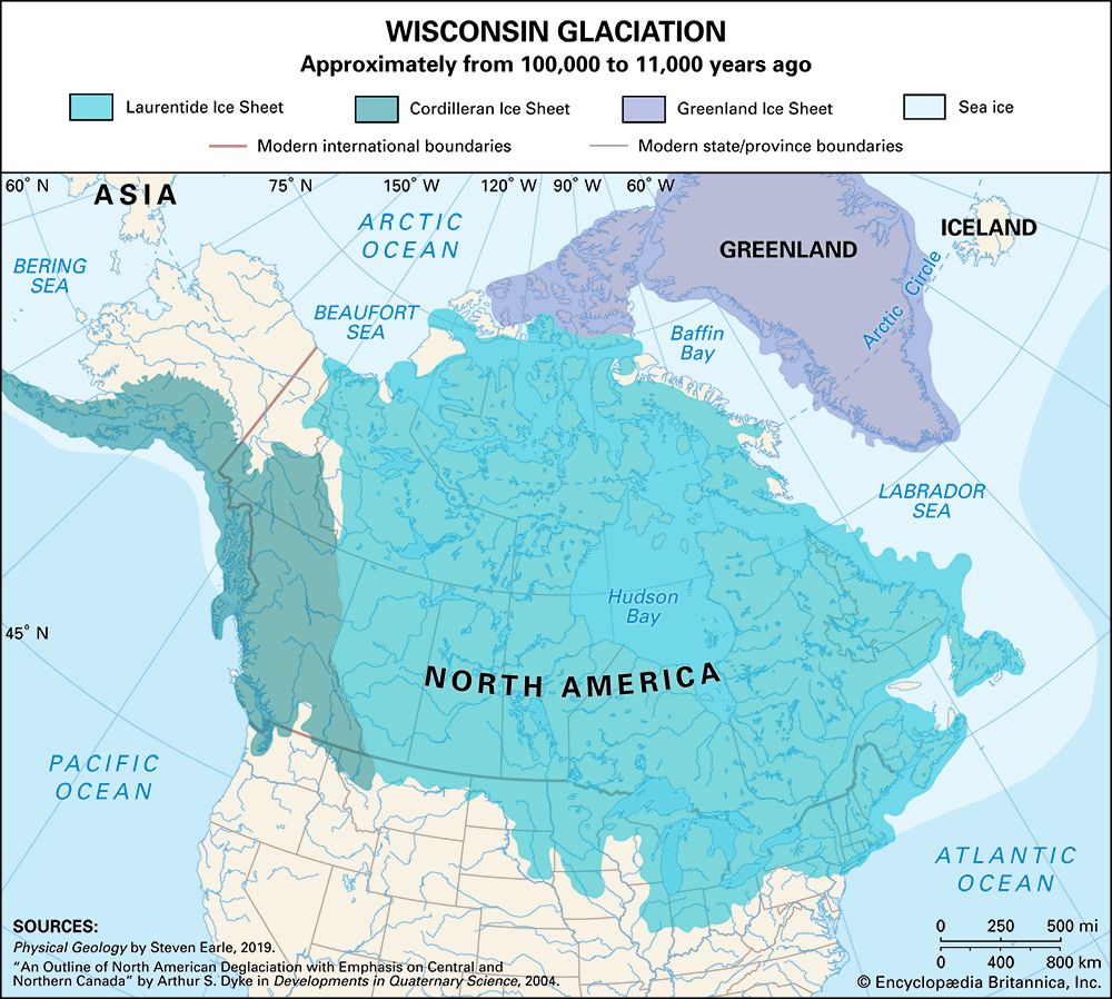
The Laurentide Ice Sheet was the primary glacial cover of North America during the Pleistocene Epoch, spanning approximately 2,600,000 to 11,700 years ago.
What is Laurentide Ice Sheet?
The Laurentide Ice Sheet was the primary glacial cover of North America during the Pleistocene Epoch, spanning approximately 2,600,000 to 11,700 years ago.1
At its peak, this massive ice sheet covered over 13,000,000 square kilometers (5,000,000 square miles), reaching thicknesses of up to 3,000 meters (10,000 feet). It likely originated on the Labrador-Ungava plateau and the mountains of the Arctic islands of Canada, eventually centering over Hudson Bay. As it expanded, it amalgamated with smaller glaciers to cover much of the continent, stretching between the Atlantic Ocean and the Rocky Mountains, and reaching as far south as latitude 37° N.12
The immense weight of the ice depressed Earth’s crust, a process that began to reverse through post-glacial rebound as the ice melted at the end of the Pleistocene. This melting also left behind distinct geological features, including U-shaped valleys, fjords, and vast areas of disarranged drainage and lakes.2
How did the weight of the ice sheet change the Earth’s crust?
The weight of a massive ice sheet causes the underlying Earth’s crust to subside, a process driven by isostatic movements. Because the crust cannot sustain the immense load of the glacier, it sinks into the mantle, with the degree of subsidence typically reaching about one-third of the ice sheet’s total thickness. For example, the central region of the Laurentide Ice Sheet caused the crust to depress by approximately 1 kilometer.3
When the ice melts, this load is removed, triggering a process known as post-glacial rebound. The ground begins to rise, with the uplift occurring rapidly at first before slowing over time. This phenomenon is still observable today; for instance, the eastern Hudson Bay area has experienced over 300 meters of uplift since deglaciation, and the land continues to rise at a rate of about 1.3 centimeters per year.3
What are some examples of landforms created by retreating glaciers?
Retreating glaciers leave behind a variety of distinct landforms shaped by both the deposition of sediments and the erosion of the landscape. These features serve as vital indicators for geologists to reconstruct the history and movement of past ice sheets.56
Depositional Landforms
As glaciers melt, they release the debris they have been transporting, creating several characteristic features:
- Moraines: These are ridges of till and outwash sand deposited at the terminal or lateral margins of a glacier. They mark the positions where an ice margin stabilized during retreat.76
- Drumlins: These are streamlined, elongate hills of sediment aligned parallel to the direction of former ice flow. They often occur in large groups known as drumlin fields.76
- Eskers: These are long, sinuous ridges of sand and gravel, often tens of meters high, formed by streams that flowed in pressurized tunnels beneath the ice.57
- Kames and Kettle Lakes: Kames are isolated mounds of stratified drift, while kettles are steep-sided depressions formed when buried blocks of stagnant ice melt. When these depressions fill with water, they become kettle lakes.58
- Outwash Plains (Sandur): Formed by meltwater streams beyond the glacier margin, these are wide, flat areas of sediment that thin as they move away from the ice.5
Erosional Landforms
Glacial retreat also reveals features sculpted by the ice’s movement:
- U-shaped Valleys and Fjords: Glacial erosion carves deep, wide valleys. When these are submerged by the sea, they form fjords.79
- Glacial Grooves and P-forms: These are smooth-walled, linear depressions carved into bedrock, often indicating the direction of ice flow.2
- Erratics: These are large rock fragments transported by glaciers that differ from the local bedrock, often left behind as the ice melts.10
How did the ice sheet influence early human migration to North America?
The presence of massive ice sheets during the Pleistocene Epoch fundamentally shaped early human migration to North America in two primary ways: by creating a land bridge and by acting as a barrier to southward movement.
The Beringia Land Bridge
During the last glacial maximum, the vast amount of water locked in glaciers caused global sea levels to drop by approximately 400 feet (120 meters). This exposed Beringia, a dry land connection between Siberia and Alaska. While much of the Northern Hemisphere was covered in ice, Beringia remained largely unglaciated, supporting cold-hardy tundra vegetation that allowed both game animals and human hunter-gatherers to move into the northwestern sector of North America.1213
Barriers and Subsequent Expansion
Once in the northwest, early migrants were held back for eons by impenetrable glacial formations. It was only when these ice sheets began to retreat—roughly 20,000 years ago—that valleys opened up, allowing humans to follow the southward progression of game animals. This migration eventually led to the population of the rest of North and South America.1314
Sources
- Laurentide Ice Sheet — Encyclopædia Britannica
- Arctic - Continental ice sheets of the past — Encyclopædia Britannica
- Pleistocene Epoch - Tectonic and isostatic movements — Encyclopædia Britannica
- isostasy — Encyclopædia Britannica
- glacial landform - Glaciofluvial deposits — Encyclopædia Britannica
- erratic — Encyclopædia Britannica
- kettle — Encyclopædia Britannica
- Quaternary - Landforms — Encyclopædia Britannica
- glacial landform - Depositional landforms of continental glaciers — Encyclopædia Britannica
- glacial landform - Small-scale features of glacial erosion — Encyclopædia Britannica
- glacial landform - P-forms and glacial grooves — Encyclopædia Britannica
- North America - The past 2.5 million years — Encyclopædia Britannica
- Beringia — Encyclopædia Britannica
- Climate change - The last deglaciation — Encyclopædia Britannica
- South American Indian - The prehistoric period — Encyclopædia Britannica
- Pleistocene Epoch - Migration of plants and animals — Encyclopædia Britannica
Published on · 4 min read