Melville Peninsula
The Melville Peninsula is a large landmass located in the territory of Nunavut, Canada. Stretching approximately 250 miles (400 km) in length and ranging…
What is Melville Peninsula?
The Melville Peninsula is a large landmass located in the territory of Nunavut, Canada. Stretching approximately 250 miles (400 km) in length and ranging between 70 and 135 miles in width, it serves as a significant geographic feature that separates the Gulf of Boothia to the west from the Foxe Basin to the east.12
What is the climate like in Nunavut?
Nunavut lies entirely within the Arctic climatic zone, characterized by bitterly cold winters and cool to cold summers. The territory is defined by its harsh, polar continental climate, where continuous permafrost underlies virtually the entire region.34
Temperature and Precipitation
Winter temperatures are intensely cold, with average daily January temperatures typically falling between −22 °F (−30 °C) and −31 °F (−35 °C). In the summer, temperatures remain low; average July temperatures generally do not exceed 41 °F (5 °C) in the far north and along the northeastern coast of Baffin Island, though they may rise above 50 °F (10 °C) in areas west of Hudson Bay.3
Precipitation is scant throughout most of the territory and falls almost entirely as snow. Annual precipitation levels are generally low, often less than 8 inches (200 mm), though amounts increase toward the east, with some areas like Bylot Island receiving more than 24 inches (600 mm). The region is also subject to significant windchill, particularly north of Hudson Bay, where strong, persistent northwest winds are common.34
What are the main geographical features of the Arctic?
The Arctic is a complex region defined by its unique geological structures, extreme climate, and distinct physical landscapes. Its geography is shaped by ancient shield areas, extensive sedimentary plains, and significant glacial history.
Major Physiographic Divisions
The Arctic’s terrain is largely categorized by its underlying geological foundations:
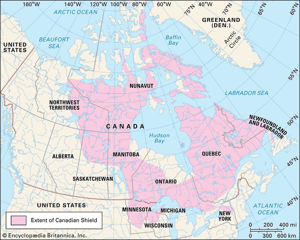
- Shield Areas: The Canadian Shield, Baltic Shield, Angaran Shield, and Aldan Shield form the ancient crystalline cores of the region. These areas often feature low, rocky landscapes with disjointed drainage and numerous lakes.89
- Sedimentary Plains: Beyond the shields, vast plains have evolved on sedimentary rock, such as the West Siberian Plain and the Mackenzie Lowlands. These regions are generally flat, occasionally broken by low rock scarps, and crossed by large rivers.8
- Fold Mountains: Orogenic activity has created mountainous regions, such as the Innuitian Mountains and the ranges in Alaska and Siberia, where peaks can exceed 10,000 feet.810
Permafrost and Surface Features
A defining characteristic of the Arctic is permafrost, which covers nearly one-quarter of Earth’s surface. This permanently frozen ground inhibits drainage, leading to the formation of shallow lakes and unique surface patterns like polygonal nets and stone circles. In areas with fine-grained sediments, ground ice can form, which, if melted, may cause the ground to lose strength and collapse.811
Ocean Floor Topography
The Arctic Ocean is not a single basin but a complex system divided by submarine ridges, such as the Lomonosov Ridge. These ridges separate the ocean into deep basins, including the Eurasia and Amerasia basins.12
How does the Foxe Basin affect the surrounding environment?
The Foxe Basin is a large arm of the Atlantic Ocean situated between the Melville Peninsula and Baffin Island in Nunavut, Canada.16
While the basin serves as a significant geographical feature north of Hudson Bay, the provided information does not detail specific environmental impacts or ecological influences it has on the surrounding region. The basin is primarily characterized by its dimensions—approximately 300 miles long and up to 250 miles wide—and its connection to Hudson Bay via the Foxe Channel. This channel remains largely icebound for most of the year, opening only during midsummer.16
We could dive deeper into the Arctic marine ecosystem if you would like to learn more about how such basins support regional biodiversity.
Sources
- Melville Peninsula — Encyclopædia Britannica
- Melville Peninsula — Merriam-Webster
- Nunavut - Climate — Encyclopædia Britannica
- Arctic - Climate of the Arctic — Encyclopædia Britannica
- Nunavut - Plant and animal life — Encyclopædia Britannica
- North America - The Arctic zone — Encyclopædia Britannica
- Inuit: Top Questions — Encyclopædia Britannica
- Arctic - Terrain of the Arctic — Encyclopædia Britannica
- Arctic Archipelago — Encyclopædia Britannica
- Arctic — Encyclopædia Britannica
- Arctic Ocean - Topography of the ocean floor — Encyclopædia Britannica
- Arctic - Geology — Encyclopædia Britannica
- Arctic - Continental ice sheets of the past — Encyclopædia Britannica
- Arctic - Vegetation — Encyclopædia Britannica
- Arctic - Drainage and soils — Encyclopædia Britannica
- Foxe Basin — Encyclopædia Britannica
- Foxe Basin — Merriam-Webster
Published on · 3 min read