Pamirs
The Pamirs are a high-altitude mountain region located in Central Asia. The area is centered on a massive orogenic uplift known as the Pamir Knot, which…
Where are the Pamirs located, and which countries does this mountain region span?
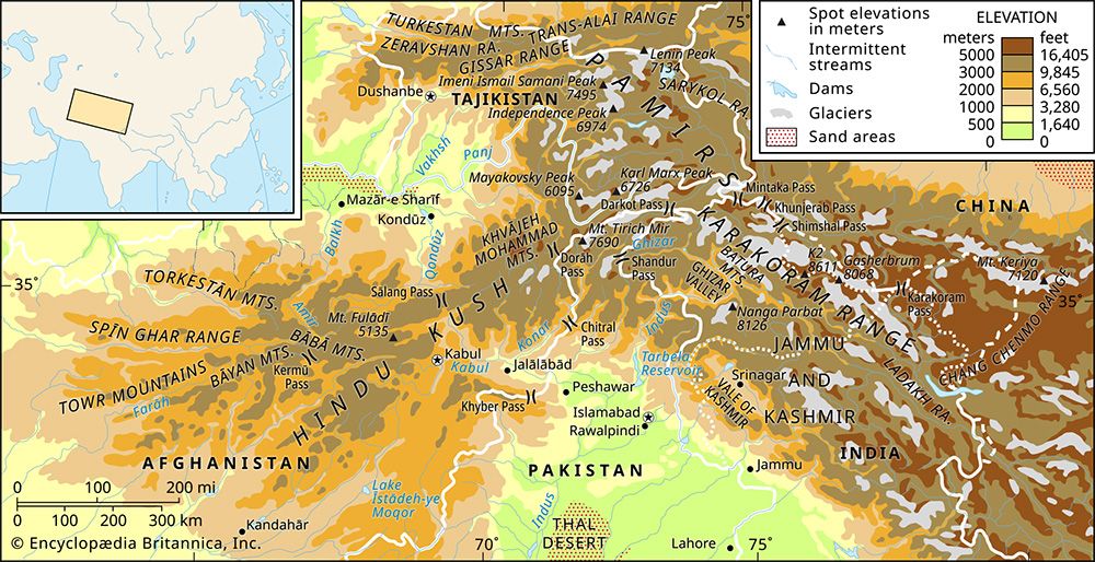
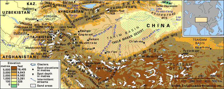
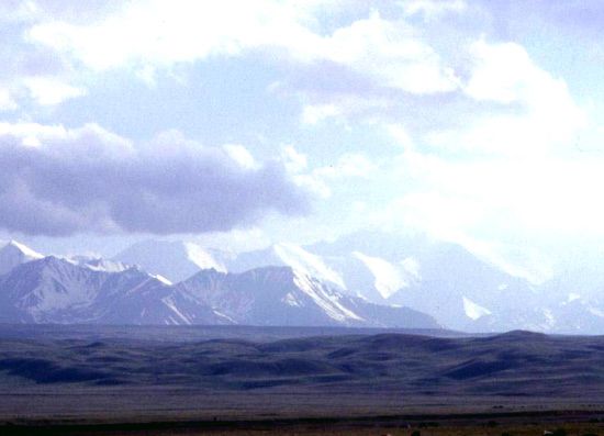
The Pamirs are a high-altitude mountain region located in Central Asia. The area is centered on a massive orogenic uplift known as the Pamir Knot, which serves as a junction for several major mountain ranges, including the Hindu Kush, the Karakoram Range, the Kunlun Mountains, and the Tien Shan.1
While the core of the region is situated within the Gorno-Badakhshan province of Tajikistan, the mountain system extends across the borders of four countries:
- Tajikistan: Contains the majority of the region.1
- Afghanistan: The southern limit is marked by the Vākhān region (Wakhan Corridor).1
- China: The eastern margin is bounded by the Sarykol pamir in the Xinjiang region.ir in the Xinjiang region.1
- Kyrgyzstan: The fringes of the mountains extend into this territory.1
How have the Pamirs influenced trade and exploration throughout history?
The Pamirs have served as a critical crossroads for trade and exploration for centuries, bridging the civilizations of East and West.
Trade and the Silk Road
From the 1st through the 7th century CE, three branches of the Silk Road traversed the Pamirs, facilitating the movement of goods and ideas across Central Asia. Today, historical trade routes continue to influence modern infrastructure; for example, a major route following the old Karatikin Silk Road connects Tajikistan through southern Kyrgyzstan to China, while the Karakoram Highway serves the eastern Pamirs in China.23
Exploration and Geopolitics
The region’s strategic importance led to intense exploration and political maneuvering:
- Early Documentation: The 2nd-century scholar Ptolemy identified the mountains as Comedae, and later travelers like Marco Polo are believed to have crossed the Vākhān region.2
- The “Great Game”: During the 19th century, the Pamirs became a focal point for British and Russian imperial interests. Explorers and representatives, such as John Wood and Ney Elias, sought to define physiographic boundaries between Russian Central Asia and British India, eventually resulting in the creation of the Afghanistan buffer state and the Wakhan CorridorAfghanistan](https://www.britannica.com/topic/history-of-Afghanistan) buffer state and the Wakhan Corridor.2
- Scientific Inquiry: Late 19th-century expeditions, primarily led by Russian scientists, shifted focus toward systematic studies of geology, glaciation, and biology, culminating in the establishment of high-elevation research stations during the Soviet period.2
What are the major geographical features of the Pamir Mountains?
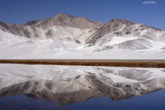
The Pamir Mountains are a complex highland region defined by a nodal orogenic uplift known as the Pamir Knot, which serves as a junction for major ranges including the Hindu Kush, Karakoram Range, Kunlun Mountains, and Tien Shan.41
Physiography and Relief
The region is divided into two distinct areas:
- Eastern Pamirs: Characterized by medium-mountain relief on a high foundation. It features rounded massifs, wide flat-bottomed valleys, and high-altitude grasslands known as pamirs.41
- Western Pamirs: A high-mountain, sharply disjointed landscape featuring alpine ridges, deep narrow ravines, and significant glaciation.4
Key peaks include Imeni Ismail Samani Peak (the highest point at 24,590 feet) and Lenin Peak.4
Drainage and Glaciation
The region is heavily glaciated, most notably by the Fedchenko Glacier. Meltwater primarily drains into the Panj and Vakhsh rivers, which converge to form the Amu Darya. Seismic activity in the region often triggers landslides that create natural dams, such as Lake Sarez.45
How do the Pamirs contribute to the water resources of Central Asia?
The Pamir Mountains serve as a vital “mountainous zone of nourishment” for Central Asia, acting as a primary source of water for the region’s arid lowlands.5
Glacial and Snowmelt Contributions
The Pamirs experience significant winter snowfall, which feeds extensive glaciers, including the massive Fedchenko Glacier extensive glaciers, including the massive Fedchenko Glacier. This accumulation of permanent snow and ice acts as a natural reservoir. As temperatures rise from spring through summer, the melting of this ice and snow provides a critical, steady supply of water that augments the flow of major river systems.5
River Systems and Irrigation
The vast majority of meltwater from the Pamirs drains into the Panj and Vakhsh rivers. The confluence of these two rivers forms the Amu Darya, one of Central Asia’s longest rivers5. This river system is essential for:5
- Agriculture: The water is diverted into extensive irrigation projects, such as the Karakum Canal, to support crops like cotton in the downstream basins.75
- Energy: The Vakhsh River supports major hydroelectric infrastructure, including the Norak (Nurek) Dam and the Rogun project, which are crucial for regional power generation.5
Sources
- Pamirs — Encyclopædia Britannica
- Pamirs - Study and exploration — Encyclopædia Britannica
- Pamirs - People and the economy — Encyclopædia Britannica
- Pamirs - Physiography — Encyclopædia Britannica
- Pamirs - Drainage — Encyclopædia Britannica
- Pamirs - Climate — Encyclopædia Britannica
- Amu Darya — Encyclopædia Britannica
Published on · 4 min read