Rocky Mountain Trench
The Rocky Mountain Trench is a prominent geological depression that extends approximately 900 miles (1,400 km) from western Montana in the United States…
What is Rocky Mountain Trench?
The Rocky Mountain Trench is a prominent geological depression that extends approximately 900 miles (1,400 km) from western Montana in the United States, through British Columbia, Canada, to the headwaters of the Yukon River.1
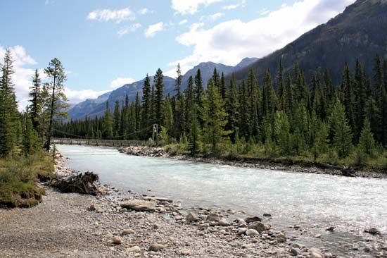
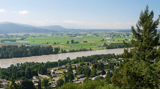
Geologically, the trench is a graben—a straight, flat-bottomed, downfaulted valley—that marks the western margin of the Canadian and Northern Rockies. Its floor is between 2 and 10 miles (3–16 km) wide and sits at an elevation of 2,000 to 3,000 feet (600–900 m) above sea level. Over time, the valley has been shaped by glaciation and contains deposits from glacial meltwaters.21
The trench serves as a natural travel route and is partially occupied by the headwaters of several major rivers, including the Kootenay, Fraser, Peace, Columbia, and Liard rivers1.
How do glaciers shape mountain valleys like the Rocky Mountain Trench?
Glaciers fundamentally reshape mountain landscapes by transforming narrow, V-shaped stream valleys into broad, U-shaped valleys with steep, often vertical sidewalls.45
Unlike rivers, which erode a narrow line along the valley floor, glaciers have greater viscosity and cross-sectional area, allowing them to contact a much larger portion of the valley. As they move, glaciers perform two primary actions:
- Removal of Debris: They clear away loose material along the base of valley walls.4
- Bedrock Erosion: They use rock debris as tools to abrade and polish the bedrock at the base and lower sidewalls, widening and deepening the valley floor to minimize frictional resistance.45
In regions like the Rocky Mountain Trench, this process creates a straighter, smoother path than a typical river valley. Furthermore, because smaller tributary glaciers erode their troughs less rapidly than the main glacier, their valleys are often left as hanging valleys high above the main floor once the ice melts, frequently resulting in waterfalls.5
What is a graben and how does it form in geology?
A graben is a depressed, elongate segment of the Earth’s crust that has dropped downward relative to the surrounding areas. The term is derived from the German word for “ditch” or “trough”.8910
How a Graben Forms
Grabens are primarily created through the process of crustal extension. When the Earth’s brittle crust is subjected to lateral tension, it fractures, creating a series of steeply dipping normal faults. As large crustal blocks or lithospheric plates diverge, the block of crust between these faults slides downward into the resulting gap.1011
Key characteristics of this formation include:
- Fault Geometry: Grabens are bounded on both sides by normal faults that typically dip toward each other.811
- Topography: The resulting landform is a flat-bottomed valley, often referred to as a rift valley.810
- Associated Features: They often occur in conjunction with horsts—raised blocks of crust—creating a series of alternating high and low terrain.811
Well-known examples of grabens include Death Valley in the United States and the Jordan–Dead Sea depression.8
Which major rivers originate in the Rocky Mountain Trench?
The Rocky Mountain Trench serves as a significant geological depression that acts as the headwaters for several major river systems. The rivers that originate in or are occupied in part by the trench include:
- Columbia River: This river follows the trench northward before bending around the northern end of the Selkirk Mountains to flow south into the United States.113
- Kootenay River: A major river system that has its headwaters within the trench.1
- Fraser River: While it rises in the Rockies near Yellowhead Pass, it is noted as one of the rivers occupying the trench.113
- Peace River: This river becomes a formidable stream within the trench before cutting eastward through the Rockies toward the plains of Alberta.113
- Liard River: Another significant river system that originates within the trench.1
Sources
- Rocky Mountain Trench — Encyclopædia Britannica
- Rocky Mountains - Physiography — Encyclopædia Britannica
- Rocky Mountains - Plant life — Encyclopædia Britannica
- glacial landform - Cirques , tarns, U-shaped valleys, arêtes, and horns — Encyclopædia Britannica
- glacial valley — Encyclopædia Britannica
- glacial landform - Glaciofluvial deposits — Encyclopædia Britannica
- North America - 1.6 to 1.3 billion years ago — Encyclopædia Britannica
- horst and graben — Encyclopædia Britannica
- tectonic basins and rift valleys - Rift valleys — Encyclopædia Britannica
- graben — Merriam-Webster
- tectonic basins and rift valleys — Encyclopædia Britannica
- normal fault — Encyclopædia Britannica
- British Columbia - Drainage — Encyclopædia Britannica
- Columbia Mountains — Encyclopædia Britannica
- Yampa River — Encyclopædia Britannica
Published on · 3 min read