Siachen Glacier
The Siachen Glacier is located in the Karakoram Range within the Himalayan region, specifically situated between the Saltoro Ridge to the west and the main…
Where is the Siachen Glacier located, and what makes it unique among glaciers?
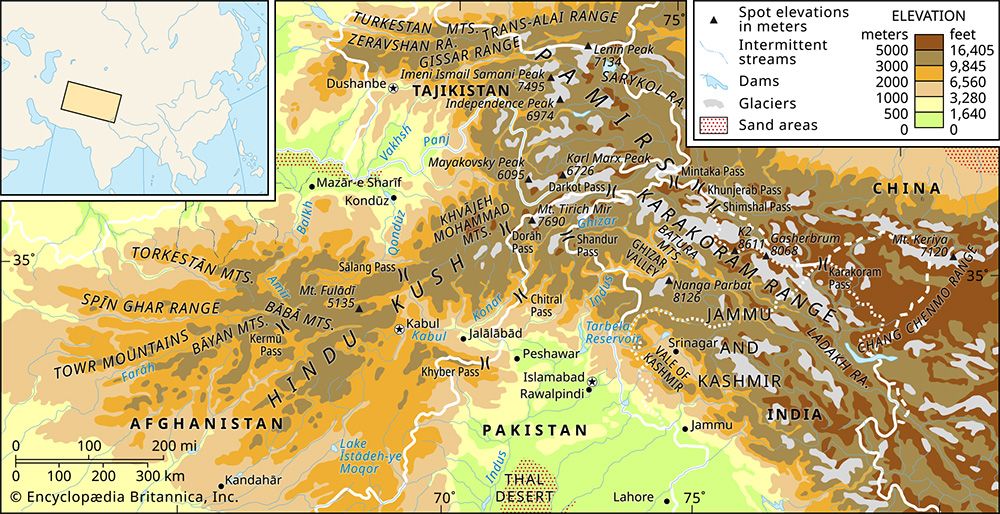
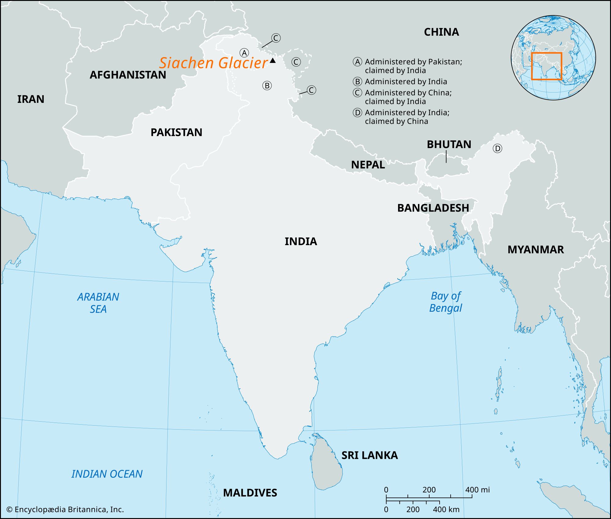
The Siachen Glacier is located in the Karakoram Range within the Himalayan region, specifically situated between the Saltoro Ridge to the west and the main Karakoram Range to the east.
It is unique for several reasons:
- Size: At 75 km (47 miles) long, it is the second-longest nonpolar glacier in the world, surpassed only by the Fedchenko Glacier in Tajikistan.1
- “Third Pole”: It lies in a region often called the “Third Pole” because its mountain glaciers contain more fresh water than anywhere else on Earth outside the polar ice caps.1
- Etymology: Its name, derived from the local Balti language, translates to “land with an abundance of roses,” referring to the wild rose species that grow nearby.1
- Geopolitics: It has been the site of a long-standing territorial dispute between India and Pakistan, leading to a high-altitude military standoff that has significantly impacted the local environment through pollution and threats to wildlife.1
What is the strategic importance of the Siachen Glacier, and why has it been a source of conflict?
The Siachen Glacier is a site of significant strategic importance and long-standing territorial tension between India and Pakistan.
Strategic Importance
The region is vital because it serves as a buffer separating Pakistan from China. For India, control of the glacier allows for the monitoring of Pakistan’s Gilgit and Baltistan regions. Conversely, the area provides Pakistan with direct access to China. The dispute originated because the 1949 cease-fire line, which divided Jammu and Kashmir, ended at map coordinate NJ 9842, leaving the glacier area unmapped and unclaimed by either side.1
Source of Conflict
The conflict escalated in the 1970s when Pakistan began granting mountaineering permits in the region, signaling a claim to the territory. In 1984, India launched the secret Project Meghdoot after receiving intelligence of a planned Pakistani deployment, successfully securing the glacier. While India retains control, the region remains a high-altitude military standoff. The harsh environment has caused thousands of troop deaths due to avalanches and extreme weather, while the military presence has caused significant environmental degradation, including pollution of the Indus River system.1
What is the geological history of the Siachen Glacier and the Karakoram Range?
The geological history of the Karakoram Range and the Siachen Glacier is defined by the massive tectonic shifts of the Cenozoic Era. The most significant event was the collision of India with the southern margin of Asia approximately 40 to 50 million years ago. This ongoing collision continues to “bulldoze” and crumple the continental crust, driving the uplift of the Himalayas and the Plateau of Tibet. India’s northward movement at a rate of about 2.4 inches (6 cm) per year maintains the extreme elevations of these mountain systems.3
The Karakorams, which serve as a central watershed for the Indus and Yarkand rivers, exhibit heavy glaciation due to their immense height. The Siachen Glacier itself provides a window into this history; while it currently spans 75 km (47 miles), evidence of past glaciation events from approximately 145,000 years ago suggests it once reached lengths of up to 165 km (103 miles). The region’s rugged topography, characterized by craggy peaks and deep ravines, remains a dynamic landscape shaped by these tectonic forces and persistent glacial activity.456
How does the Siachen Glacier contribute to the water resources of the surrounding regions?
The Siachen Glacier serves as a critical component of the regional water cycle, acting as a primary source for the Indus River system. As a temperate-zone glacier, it generates significant runoff during the ablation season, which forms the Nubra River. This river subsequently flows into the Shyok River, which eventually drains into the Indus, a vital lifeline for agriculture and human settlement in the region.3
The glacier’s contribution to water resources is characterized by several key processes:
- Meltwater Supply: The high-elevation zones of the Karakoram Range act as a watershed where the melting of seasonal and perpetual snows and glaciers feeds major river channels.1
- Sediment Transport: Glacial meltwater carries pulverized stone, known as rock flour, which gives the Indus its high suspended sediment load. This material is a natural byproduct of glacial erosion.1
- Groundwater Recharge: Beyond surface runoff, groundwater accumulates in the rocky talus surrounding the glacier, contributing to consistent water flow throughout the year.1
- Regional Importance: Because the region contains vast amounts of fresh water, it is often referred to as the “Third Pole,” highlighting its role in sustaining downstream ecosystems and irrigation systems.3
Sources
- Siachen Glacier — Encyclopædia Britannica
- Ladakh - Border disputes — Encyclopædia Britannica
- Karakoram Range - Glaciation and drainage — Encyclopædia Britannica
- Asia - Cenozoic events in the Alpide plate boundary zone and in the Arabian and Indian cratons — Encyclopædia Britannica
- Karakoram Range — Merriam-Webster
- Karakoram Range - Physiography — Encyclopædia Britannica
- Karakoram Range — Encyclopædia Britannica
- Himalayas - Drainage of the Himalayas — Encyclopædia Britannica
- Indus River - Irrigation of the Indus River — Encyclopædia Britannica
Published on · 4 min read