Trans-Alai Range
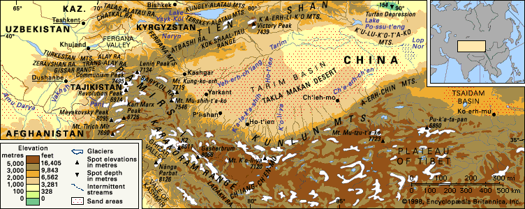
The Trans-Alai Range is a prominent mountain system located on the border between Kyrgyzstan and Tajikistan. As the northernmost range of the Pamirs, it…
What is Trans-Alai Range?
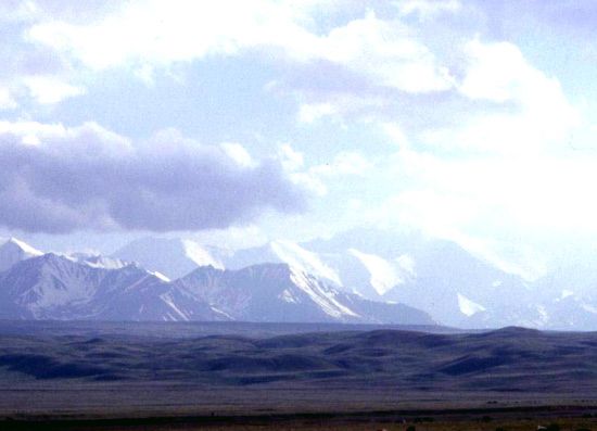
The Trans-Alai Range is a prominent mountain system located on the border between Kyrgyzstan and Tajikistan. As the northernmost range of the Pamirs, it stretches approximately 150 miles (240 km) in an unbroken, snow-capped chain.12
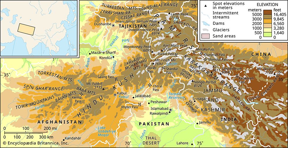
The range is situated between the Alai Valley to the north and the Muksu and Markansu valleys to the south. Its highest elevation is Lenin Peak, which reaches 23,406 feet (7,134 meters). The region features extensive glaciation covering about 460 square miles (1,190 square km), while the lower slopes are characterized by steppe and alpine pastures. The range is traversed by the Pamirs Highway, which crosses the Kyzyl-Art Pass at an elevation of 14,042 feet (4,280 meters).1
What are the Pamir Mountains?
The Pamirs are a vast, high-altitude mountain region in Central Asia. Centered on the “Pamir Knot,” this nodal uplift serves as the origin for several major Asian mountain ranges, including the Hindu Kush, Karakoram Range, Kunlun Mountains, and Tien Shan.3
Geography and Climate
Most of the region lies within Tajikistan, specifically the Gorno-Badakhshan province, with fringes extending into Afghanistan, China, and Kyrgyzstan. The landscape is divided into two distinct types:3
- Eastern Pamirs: Characterized by high-altitude, undulating grasslands (known locally as pamirs) and medium-mountain relief on a raised foundation.34
- Western Pamirs: Defined by high, sharply disjointed mountains, deep ravines, and extensive glaciation.4
The climate is arid and continental, featuring frigid winters and dry, warm summers.5
People and Economy
The region is home to Kyrgyz pastoralists in the east and Mountain Tajiks in the western valleys. Economic life centers on agropastoralism, including the herding of yaks, sheep, and goats, alongside the cultivation of grains and orchards in lower valleys. Infrastructure, such as the Karakoram Highway, supports regional connectivity and trade.67
How do glaciers shape mountain landscapes?
Glaciers are powerful agents of landscape transformation, reshaping mountainous terrain through intense processes of erosion and deposition.
Erosional Landforms
Glaciers drastically alter the topography by carving out distinct features:
- U-Shaped Valleys: Unlike rivers, which create narrow V-shaped valleys, glaciers widen and deepen existing valleys into broad, parabolic U-shaped valleys by eroding the bedrock along the base and sidewalls.89
- Cirques, Arêtes, and Horns: At the head of a glacier, ice carves out an amphitheatre-shaped hollow known as a cirque. When multiple cirques erode a mountain from different sides, they leave behind sharp, knife-edge ridges called arêtes and pointed, pyramid-like peaks known as horns, such as the Matterhorn.810
- Tarns: Over-deepened basins scoured into the bedrock of cirques often fill with water after the ice retreats, forming mountain lakes called tarns.8
Depositional Landforms
As glaciers move, they transport vast amounts of rock debris, which is deposited as the ice melts:
- Moraines: These are ridges of till (unsorted debris) left behind by the glacier. Lateral moraines form along the valley slopes, while end moraines (including the largest, the terminal moraine) form at the glacier’s snout.911
These processes collectively transform rugged, high-altitude environments into the dramatic, iconic scenery observed in ranges like the Alps.910
What is the significance of the Pamir Highway?
The Pamir Highway is a vital infrastructure network in Central Asia that serves both strategic and economic purposes. Its significance is defined by several key functions:
- Military and Political Connectivity: A major frontier road within the region facilitates the movement of military garrisons across the Tajik and Kyrgyz portions of the Pamirs. Historically, these routes have been essential for maintaining control and connectivity in a region that served as a buffer zone between major powers during the 19th century.67
- Regional Integration: The highway links Tajikistan with the city of Osh in Kyrgyzstan, providing a critical transit corridor for the mountainous population. Additionally, routes following the ancient Silk Road paths connect Tajikistan through southern Kyrgyzstan to China.6
- Access to Remote Settlements: The network of motor-vehicle tracks, including those constructed in the 1980s, provides essential access to isolated communities, such as those in the Vākhān region of Afghanistan, supporting the daily lives and pastoral activities of the local inhabitants.6
While distinct from the Karakoram Highway—which serves the Chinese Pamirs and connects Pakistan to China—these roads collectively represent the primary means of traversing some of the most rugged and inaccessible terrain in Asia.612
We could dive deeper into the history of the Silk Road trade routes that once crossed these mountains, or perhaps explore the modern challenges of maintaining these high-altitude roads.
Sources
- Trans-Alai Range — Encyclopædia Britannica
- Trans Alai — Merriam-Webster
- Pamirs — Encyclopædia Britannica
- Pamirs - Physiography — Encyclopædia Britannica
- Pamirs - Climate — Encyclopædia Britannica
- Pamirs - People and the economy — Encyclopædia Britannica
- Karakoram Highway — Encyclopædia Britannica
- glacial landform - Cirques , tarns, U-shaped valleys, arêtes, and horns — Encyclopædia Britannica
- Pleistocene Epoch - Glaciation — Encyclopædia Britannica
- glacial landform - Moraines — Encyclopædia Britannica
- Alps - Geology — Encyclopædia Britannica
- Pamirs - Study and exploration — Encyclopædia Britannica
Published on · 3 min read