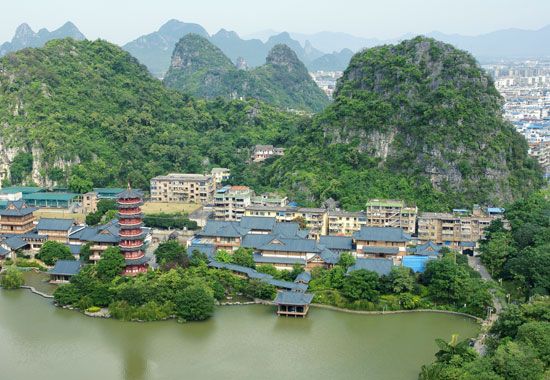
Yu River
The Yu River is a significant waterway located in southern China and serves as a key component of the region's transportation system. It originates from two…
What is Yu River?
The Yu River is a significant waterway located in southern China and serves as a key component of the region’s transportation system. It originates from two branches in southeastern Yunnan province and flows approximately 400 miles (650 km) eastward through Guangxi province.1
Along its course, the river receives the Zuo River near Nanning before uniting with the Hongshui River at Guiping. This confluence forms the Xun River, which is known as the Xi River once it reaches Guangdong province1.1
It is important to distinguish the Yu River from the Yuan River, a separate 635-mile-long waterway in Guizhou and Hunan provinces that discharges into Dongting Lake and eventually the Yangtze River.2
What is the Xi River system?
The Xi River system is a network of waterways that forms the longest river in southern China. Stretching 1,216 miles (1,957 km) from the highlands of Yunnan province to the South China Sea, it serves as a vital commercial artery for the region.3
Geography and Flow
The system drains a vast basin of 173,000 square miles (448,000 square km). While shorter than the Yangtze River and the Huang He, its volume of flow is second only to the Yangtze. The river’s path is characterized by karst landscapes, featuring cavernous valleys, steep gorges, and underground drainage.3
The system evolves through several names as it flows eastward:
- Nanpan River: The primary headstream in the Yunnan-Guizhou Plateau.3
- Hongshui River: Formed after the Nanpan receives the Beipan River.3
- Qian River: The section following the confluence with the Liu River.3
- Xun River: Formed after the Qian joins the Yu River.3
- Xi River: The name applied to the lower course once it enters Guangdong province.3
Ultimately, the Xi joins the Bei and Dong rivers to form the Pearl River Delta, a densely populated and intensively cultivated region.3
How do rivers influence transportation in southern China?
In southern China, rivers serve as essential arteries for commerce and transportation, moving goods and passengers across regions where railway and road construction is often difficult or costly.5
The Role of Waterways
Inland water transport has been a cornerstone of the regional economy since ancient times. Because rivers provide a lower-cost alternative for moving bulk goods compared to rail or road, they remain vital to China’s transport network. The government has long prioritized the development of these routes through dredging, channel widening, and the construction of port facilities to improve navigation.53
Key Transportation Systems
- The Xi River System: This is the primary commercial waterway of South China. It links major economic hubs—including Guangzhou, Wuzhou, Hong Kong, and Macau—with the interior. While larger vessels can reach Wuzhou, smaller craft and junks navigate the middle and upper courses, as well as the Bei and Dong rivers.65
- The Pearl River Delta: This dense network of channels and canals is critical for international commerce and trade with the interior, accounting for a significant portion of Guangdong province’s total traffic tonnage4.4
Despite their importance, navigation can be hampered by seasonal water fluctuations, rapids, and shallow channels in certain areas, necessitating the use of specialized vessels or manual hauling techniques in some sections.56
What are the major geographical features of Guangxi province?
Guangxi is an autonomous region in southern China characterized by a diverse and rugged landscape that generally slopes from the north and northwest toward the south and southeast.1213
Topography and Relief
The region functions as a tableland with varying elevations:
- Highlands: The northwest edge reaches the Yunnan-Guizhou Plateau, with elevations between 3,000 and 6,000 feet (900 to 1,800 meters). Significant mountain ranges include the Jiuwan, Fenghuang, and Yuecheng ranges in the north, and the Duyang Mountains in the west, which rise to approximately 6,500 feet (2,000 meters).12
- Hilly Country: The majority of the region consists of hilly terrain ranging from 1,500 to 3,000 feet (450 to 900 meters) in height.12
- Lowlands: Located primarily in the southeast, these areas sit at elevations between 300 and 1,500 feet (90 and 450 meters).12
Karst Landscapes
A defining feature of Guangxi is its extensive karst topography, formed by the predominance of limestone. This landscape features spectacular pinnacles, spires, sinkholes, and complex cave systems, particularly near Guilin. These formations were designated a UNESCO World Heritage site in 2007.12
Drainage
The region is defined by a dense network of rivers, including the Hongshui, Liu, Qian, and Gui, which generally flow southeastward to merge into the Xi River system. The hilly areas are typically covered in red soil, while the river lowlands contain fertile alluvial soil.14
Sources
- Yu River — Encyclopædia Britannica
- Yuan River — Encyclopædia Britannica
- Xi River system — Encyclopædia Britannica
- Guangdong - Transportation of Guangdong — Encyclopædia Britannica
- China - Waterways of China — Encyclopædia Britannica
- Guangxi - Transportation — Encyclopædia Britannica
- Yellow River - Economic development — Encyclopædia Britannica
- Yangtze River - Navigation of the Yangtze River — Encyclopædia Britannica
- Pearl River Delta — Encyclopædia Britannica
- Guangdong - Drainage — Encyclopædia Britannica
- Jialing River — Encyclopædia Britannica
- Guangxi - Relief — Encyclopædia Britannica
- Guangxi - Agriculture, forestry, and fishing — Encyclopædia Britannica
- Guangxi - Economy of Guangxi — Encyclopædia Britannica
- Guangxi — Encyclopædia Britannica
- Guangxi - Drainage and soils — Encyclopædia Britannica
- Guizhou - Relief — Encyclopædia Britannica
Published on · 3 min read