Guainía River
The Guainía River is a significant waterway located in northwest South America. It originates in the rain forest of eastern Colombia and flows in an…
What is Guainía River?
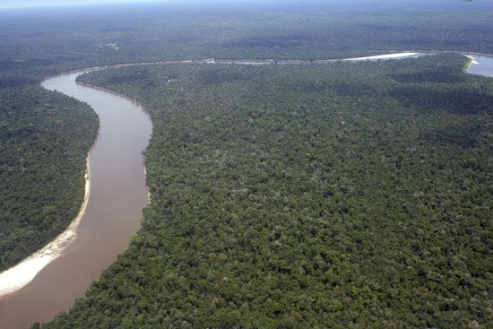
The Guainía River is a significant waterway located in northwest South America. It originates in the rain forest of eastern Colombia and flows in an eastward, then northeastward and southeastward direction, serving as a portion of the border between Colombia and Venezuela.1
Spanning approximately 400 miles (640 km), the river eventually joins the Casiquiare River near San Carlos de Río Negro. At this confluence, it becomes the Negro River, for which it serves as one of the primary headstreams. The river also lends its name to the departamento of Guainía, a region in eastern Colombia characterized by tropical rainforests and savannas.12
What is the significance of the Casiquiare River in the Amazon basin?
The Casiquiare River, also known as the Casiquiare Channel, is a unique natural waterway in southern Venezuela that serves as a vital hydrological link between two major South American river systems: the Orinoco River and the Amazon River basin. and the Amazon River basin.54
Its primary significance lies in its role as a natural bifurcation. Below the town of La Esmeralda, a portion of the Orinoco’s water flows southward into the Casiquiare. This channel meanders for approximately 140 miles (225 km) before joining the Guainía River to form the Negro River. Because the Negro River is a major affluent of the Amazon, the Casiquiare effectively creates a continuous water connection between the Orinoco and Amazon systems, a feature that is rare in global river geography.56
Historically, this connection was confirmed by Jesuit missionaries in 1744 and later studied by the naturalist Alexander von Humboldt in 1800, highlighting its importance in the early exploration of the region.7
How do tropical rainforests influence the flow of rivers in Colombia?
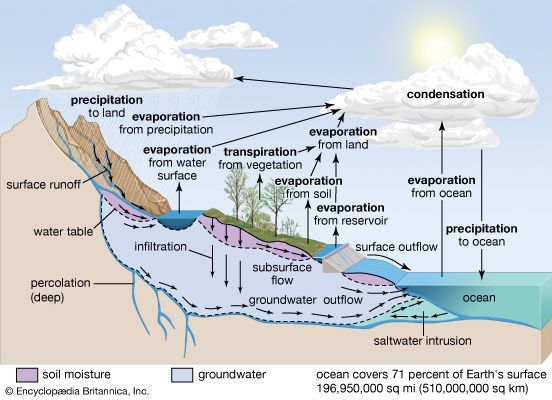
Tropical rainforests play a critical role in regulating the hydrologic cycle and influencing the flow of rivers in Colombia, particularly within the Amazon River basin.89
The primary mechanism for this influence is the process of “recycled rainfall.” Through surface transpiration and evaporation, the dense forest vegetation releases significant amounts of water vapor into the atmosphere, which eventually returns to the surface as precipitation. In the Amazon region, this local process accounts for nearly half of the total rainfall, ensuring a consistent water supply for the river systems that might otherwise be reduced in central continental regions.89
Conversely, the removal of these forests through deforestation can have detrimental effects on river stability. As seen in the Magdalena River system, deforestation and the resulting soil erosion have led to increased silting and greater flow variation, which negatively impacts the river’s utility and health. By maintaining the forest cover, the ecosystem helps stabilize soil and regulate the volume and consistency of river discharge, preventing the extremes of drought and flooding that often follow large-scale land clearing.108
What are the main differences between the Amazon and Orinoco river systems?
The Amazon and Orinoco river systems are two of South America’s most significant drainage basins, yet they differ substantially in scale, geography, and physical characteristics.
Key Differences
- Scale and Volume: The Amazon River is the world’s largest drainage system by both basin area and discharge volume. It drains approximately 2.7 million square miles (7 million square km) and carries about one-fifth of the world’s total riverine freshwater runoff. In contrast, the Orinoco River basin is the continent’s third largest, covering about 366,000 square miles (948,000 square km).14515
- Delta Formation: The Amazon does not form a traditional delta; instead, its massive sediment load is transported northward by coastal currents. The Orinoco, however, forms an extensive delta spanning about 275 miles along the Atlantic coast, characterized by an intricate network of canals and islands.1617
- Geography and Terrain: The Orinoco flows in a giant arc through the Llanos, a vast savanna region, and includes a unique “Region of the Rapids” where it forces its way through granite boulders. The Amazon is primarily a lowland river system, characterized by a very gentle gradient and vast floodplains known as várzeas.18171614
- Hydrological Connection: A unique feature of the Orinoco system is the Casiquiare channel, a natural bifurcation that allows water to flow from the Orinoco into the Amazon basin via the Negro River, creating a rare inter-basin link.1715
Sources
- Guainía River — Encyclopædia Britannica
- Guainía — Encyclopædia Britannica
- list of rivers - South America — Encyclopædia Britannica
- Casiquiare — Encyclopædia Britannica
- Orinoco River - Physiography of the Orinoco — Encyclopædia Britannica
- Orinoco River - History of exploration — Encyclopædia Britannica
- Casiquiare — Merriam-Webster
- Colombia - Rivers and soils — Encyclopædia Britannica
- Orinoco River - Climate of the Orinoco River — Encyclopædia Britannica
- Colombia - Climate of Colombia — Encyclopædia Britannica
- Status of the world’s tropical forests - Global implications of deforestation — Encyclopædia Britannica
- Amazon River - Soils of the Amazon River — Encyclopædia Britannica
- Climate - Recycled rainfall — Encyclopædia Britannica
- Orinoco River — Encyclopædia Britannica
- South America - Rivers of South America — Encyclopædia Britannica
- Amazon River - Hydrology of the Amazon River — Encyclopædia Britannica
- Amazon basin — Encyclopædia Britannica
- Amazon River — Encyclopædia Britannica
- Peru - Lakes and rivers — Encyclopædia Britannica
Published on · 3 min read