Residual Landform
A residual landform is a feature that persists as a remnant of an ancient landscape, having escaped destruction or burial to remain part of the modern…
What is residual landform?
A residual landform is a feature that persists as a remnant of an ancient landscape, having escaped destruction or burial to remain part of the modern terrain. These landforms often result from shifts in climatic conditions, though they may also be formed by volcanism or crustal movements such as uplift and downwarping.1
Common examples include:
- Extinct volcanic cones1
- Inactive stone rivers from glacial-fringe climates1
- Abandoned drainage systems and strandlines1
- Fixed sand dunes from drier historical climates1
- Marine terraces and plunging sea cliffs formed by past sea-level changes1
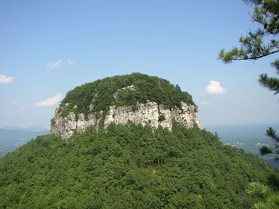
Additionally, some geomorphologists classify isolated hills of hard rock—often called inselbergs or monadnocks—as residual features, as they remain standing while the surrounding softer rock is removed by weathering and erosion. The prevalence of these features varies significantly across different landscapes.21
What is the difference between an inselberg and a monadnock?
While the terms monadnock and inselberg are often used as synonyms to describe isolated hills of resistant bedrock that stand above surrounding plains, they are distinguished primarily by their geographic and climatic contexts.526
- Monadnocks: These are typically associated with humid, temperate regions. The term is derived from Mount Monadnock in New Hampshire, U.S., and refers to remnants of bedrock that have resisted erosion due to their composition, such as quartzite or massive volcanic rock.5
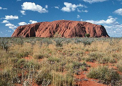
- Inselbergs: This term, meaning “island mountain” in German, is traditionally used to describe similar landforms found in tropical or arid environments, such as those observed by early explorers in southern Africa. Famous examples include Uluru/Ayers Rock and the Olga Rocks in Australia Olga Rocks in Australia.576
While some sources treat the terms as interchangeable, geomorphologists often maintain the distinction based on the specific environmental conditions under which these paleoforms developed.57
How does weathering contribute to the formation of these landforms?
Weathering is the primary driver in the formation of inselbergs and monadnocks, acting as a selective force that disintegrates weaker surrounding rock while leaving more resistant masses intact.
The Role of Weathering
Weathering involves the physical, chemical, and biological breakdown of rock in situ. For landforms like inselbergs, a critical process is subsurface weathering. In this scenario, moisture penetrates joints and fractures in the bedrock, causing the surrounding rock to decompose more rapidly than the core of the mass.46
- Chemical Weathering: In humid or tropical environments, circulating water triggers solution, carbonation, and oxidation, which alter the mineral composition of the rock, effectively lowering the surrounding plains.4
- Physical Weathering: Mechanical processes—such as thermal expansion, pressure release, and crystal growth—further disintegrate the less resistant material.4
As these surrounding areas are lowered by erosion, the more monolithic, resistant core remains as a prominent, isolated feature. Because these structures are often composed of massive, less fractured rock, they resist the weathering that degrades the adjacent landscape, allowing them to persist as paleoforms for millions of years.46
What are some examples of depositional landforms?
Depositional landforms are created through the accumulation of sediment, such as sand, gravel, or silt, in environments where transport energy decreases. These features are common in both coastal and glacial settings.
Coastal Depositional Landforms
- Beaches: Primary features of depositional coasts, often found on barrier islands and strand plains where sediment accumulates.8
- Coastal Dunes: Large, wind-blown accumulations of sand that form landward of the beach. They include features like coppice mounds and foredunes, which help coasts grow seaward.9
- Deltas: Formed at river mouths where sediment discharge exceeds the capacity of coastal processes to remove it. They vary in shape based on river, wave, and tidal influence, such as the river-dominated Mississippi Delta or the tide-dominated Ganges-Brahmaputra Delta.10
Glacial Depositional Landforms
- Flutes: Elongate tails of till deposited by glaciers as they flow around obstacles like boulders or bedrock knobs.11
- Glaciolacustrine Deposits: Sediments that accumulate in glacial lakes, including beach ridges and flat-lying lake plains formed by rhythmites or varves.12
Sources
- residual landform — Encyclopædia Britannica
- Did you know? — Merriam-Webster
- glacial landform - Small-scale features of glacial erosion — Encyclopædia Britannica
- weathering — Encyclopædia Britannica
- monadnock — Encyclopædia Britannica
- inselberg — Encyclopædia Britannica
- monadnock — Merriam-Webster
- coastal landforms - Beaches and coastal dunes — Encyclopædia Britannica
- glacial landform - Meltwater deposits — Encyclopædia Britannica
- glacial landform - Flutes — Encyclopædia Britannica
- coastal landforms - Landforms of erosional coasts — Encyclopædia Britannica
- glacial landform - Glaciolacustrine deposits — Encyclopædia Britannica
- coastal landforms - Coastal dunes — Encyclopædia Britannica
- coastal landforms - Deltas — Encyclopædia Britannica
Published on · 3 min read