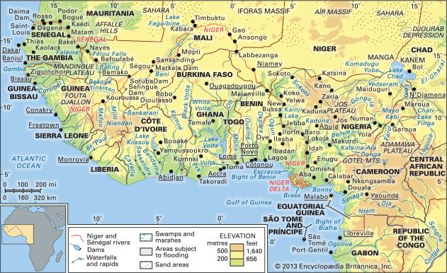
Rokel River
The Rokel River is a major waterway in West Africa that rises in the Guinea Highlands of north-central Sierra Leone. It follows a 250-mile (400-km)…
What is Rokel River?
The Rokel River is a major waterway in West Africa that rises in the Guinea Highlands of north-central Sierra Leone. It follows a 250-mile (400-km) southwesterly course, draining a basin of approximately 4,100 square miles (10,620 square km).1
As it nears the coast, the river empties into the estuary of the Sierra Leone River, which flows into the Atlantic Ocean. This estuary is vital to the region, hosting the major ports of Freetown and Pepel, and supporting local commerce. In addition to its geographical importance, the river basin has been utilized for agricultural development, specifically for smallholder tobacco cultivation.21
What is the significance of the Sierra Leone River estuary?
The Sierra Leone River estuary is a critical geographical and economic feature of western Sierra Leone. Formed by the confluence of the Rokel River and Port Loko Creek, this 25-mile-long waterway serves as a vital hub for the nation’s maritime activity.1
Its significance is defined by several key factors:
- Major Port Facilities: The estuary hosts the country’s two primary ports: Freetown harbour, which handles the nation’s imports and agricultural exports, and the port at Pepel, which has historically served as a terminal for mineral ore transport.13
- Natural Navigation: The narrowing of the estuary near Freetown creates a powerful tidal scour, reaching speeds of up to six knots. This natural phenomenon is essential for maintaining a deepwater channel, preventing the buildup of silt and ensuring accessibility for shipping.1
- Transportation and Infrastructure: Beyond maritime trade, the estuary supports local commerce, including the transport of vegetables to Freetown markets. Additionally, the international airport at Lungi is strategically located on the river’s north bank, opposite Freetown.13
- Ecological Value: The estuary’s saline tidal areas support mangrove swamps, which are integral to the local ecosystem and provide habitats for a diverse range of fish and shellfish.4
How do the Guinea Highlands influence rivers in West Africa?
The Guinea Highlands serve as a vital hydrological center for West Africa, acting as a primary watershed that dictates the direction and flow of numerous major rivers.67
A Continental Divide
The highlands function as a critical drainage divide, separating streams that flow in different directions across the region.7
- Northward Flow: Rivers such as the Niger River and its major tributaries—including the Milo, Sankarani, and Bagoé—originate in the highlands and flow northeasterly toward Mali. Similarly, the headwaters of the Sénégal River, the Bafing and Bakoye, flow northward before uniting.67
- Southward and Westward Flow: The highlands also give rise to rivers that traverse the coastal plains to reach the Atlantic Ocean. These include the Gambia River, the Konkouré, and various rivers in Sierra Leone and Liberia, such as the Saint Paul River and the Moa River -River) and the Moa River.68
Hydrological Characteristics
Because the highlands are well-watered with significant annual precipitation, they provide a consistent source of water for these river systems. However, the terrain often results in middle courses interrupted by rapids, which limits inland navigation. Furthermore, because the region experiences distinct wet and dry seasons, these rivers exhibit considerable seasonal fluctuations in their water levels.789
What are the main economic activities along the Rokel River?
Economic activities along the Rokel River are primarily focused on agriculture and energy development:
- Agriculture: The river basin supports smallholder tobacco cultivation, which has been successfully developed in the region. Additionally, the river serves as a transport route for boats carrying vegetables to the markets in Freetown.21
- Energy: The river possesses significant potential for hydroelectric power due to the country’s deeply incised river valleys. The Bumbuna hydroelectric project, located on the Rokel (also known as the Seli) River, represents a major infrastructure effort to harness this energy, though its construction was significantly delayed by civil conflict.10
While other regions of Sierra Leone are heavily involved in the mining of diamonds, bauxite, and rutile, these activities are largely concentrated in other river systems or specific plateau areas rather than along the course of the Rokel itself.10
Sources
- Sierra Leone River — Encyclopædia Britannica
- Rokel River — Encyclopædia Britannica
- Sierra Leone - Transportation — Encyclopædia Britannica
- Sierra Leone - Relief — Encyclopædia Britannica
- Sierra Leone - Plant and animal life — Encyclopædia Britannica
- Guinea - Drainage and soils — Encyclopædia Britannica
- Guinea Highlands — Encyclopædia Britannica
- Guinea - Climate — Encyclopædia Britannica
- Sierra Leone - Drainage — Encyclopædia Britannica
- Sierra Leone - Resources and power — Encyclopædia Britannica
Published on · 3 min read