Turan Plain
The Turan Plain, also known as the Turan Lowland, is an extensive, arid region located in Central Asia, spanning parts of Kazakhstan, Uzbekistan, and…
What is Turan Plain?
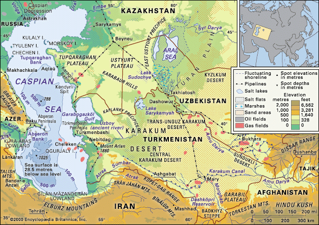
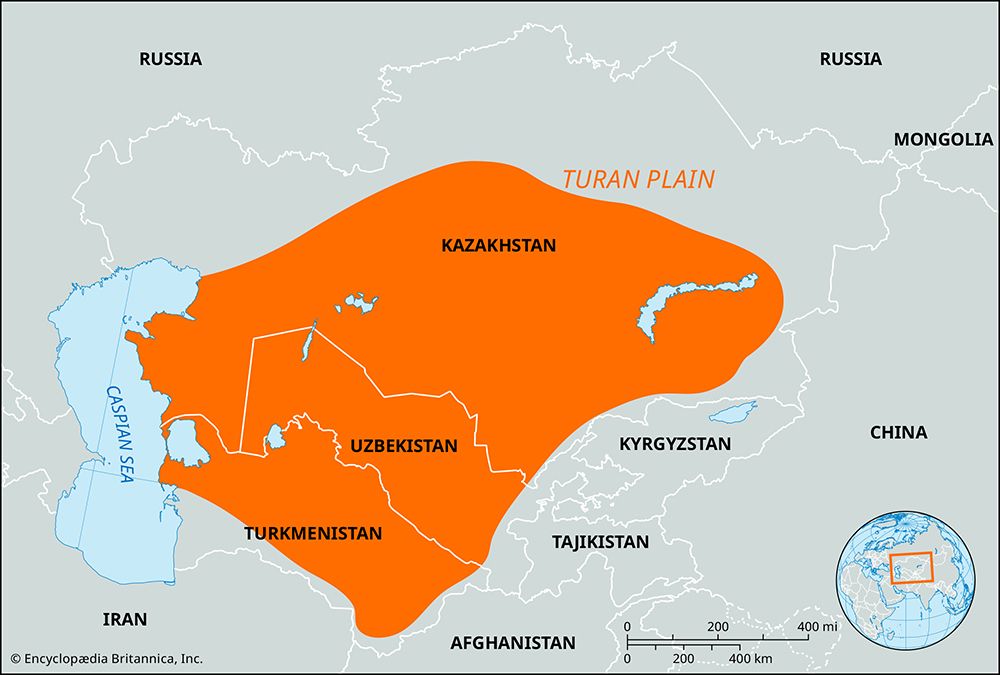
The Turan Plain, also known as the Turan Lowland, is an extensive, arid region located in Central Asia, spanning parts of Kazakhstan, Uzbekistan, and Turkmenistan. It is geographically bounded by the Caspian Sea to the west, the Kazakh uplands to the north, the Kopet-Dag Range to the south, and the foothills of the Tien Shan, Pamir, and Alay mountains to the east.12
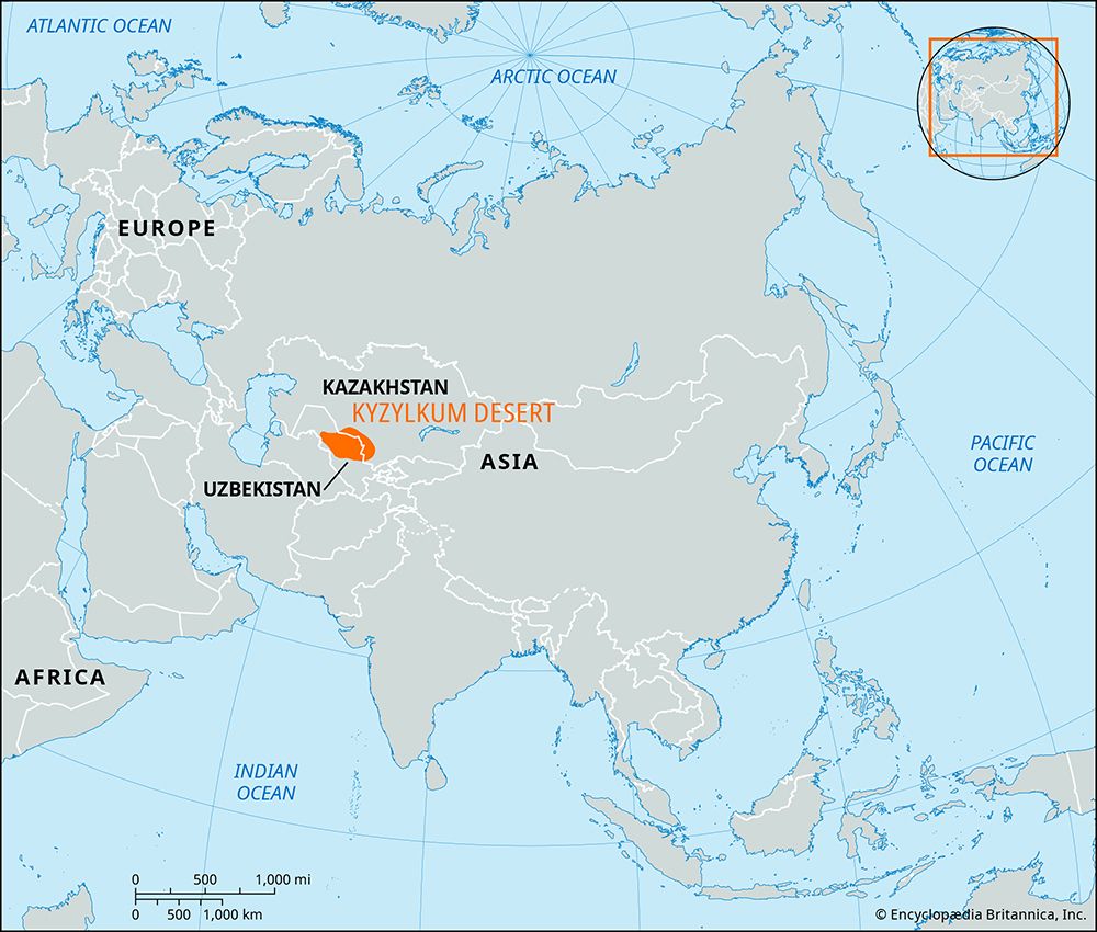
The landscape is defined by two major deserts, the Karakum and the Kyzylkum, which are separated by the valley of the Amu Darya river. Both the Amu Darya and the Syr Darya flow through the plain, eventually draining into the Aral Sea. The region is characterized by sedimentary rock, sand dunes, and sparse, drought-resistant vegetation. Due to its inland location, the area experiences a strongly continental climate with extreme temperature fluctuations between seasons and even within a single day.13
What caused the Aral Sea to shrink?
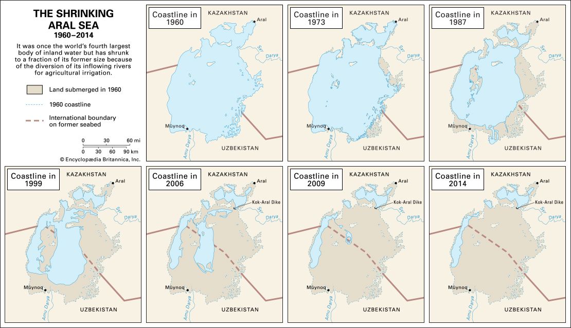
The shrinkage of the Aral Sea is primarily the result of large-scale water diversion for agricultural irrigation initiated by the Soviet Union in the 1960s.
To convert vast areas of arid land in Central Asia into productive farmland, the government diverted the waters of the Amu Darya and Syr Darya rivers—the sea’s primary sources of inflow. As these rivers were increasingly consumed by irrigation projects, the amount of water reaching the lake plummeted, causing it to shrink rapidly due to evaporation. By the 1980s, the rivers often dried up entirely before reaching the sea, leading to a catastrophic loss of volume and surface area.
This environmental disaster destroyed the local fishing industry, increased water salinity, and created toxic dust storms from the exposed seabed, which caused severe health crises for local populations. While some efforts have been made to stabilize parts of the lake, such as the construction of the Kok-Aral Dam, the overall ecological impact remains profound.56
How do plants survive in the Karakum and Kyzylkum deserts?
Plants in the Karakum and Kyzylkum deserts survive through a variety of specialized adaptations that allow them to endure extreme aridity and moisture shortages. These plants, known as xerophytes, employ several strategies to manage water loss and maximize the use of infrequent rainfall:
- Ephemeral Growth: A significant portion of the desert flora consists of ephemeral plants. These species survive dry periods as dormant, resistant seeds. Following the humid spring rains, they germinate, grow, and reproduce rapidly within a few weeks before the soil dries out again.78
- Water Storage and Deep Roots: Some plants, such as the white saxaul (Haloxylon persicum), rely on deep root systems to access underground water. Others utilize water storage organs to hold moisture for later use.78
- Morphological Adaptations: To reduce transpiration, many desert plants have evolved reduced leaf surface areas, waxy coatings, or hairy/reflective leaf coverings that minimize water loss and sunlight absorption.9108
- Dormancy: Perennial plants may become physiologically inactive during dry spells, remaining desiccated until moisture becomes available, at which point they resume activity.8
What is a continental climate?
A continental climate is a climate type characterized by significant temperature variations between seasons, a phenomenon driven by the concept of continentality. Because land surfaces have lower heat capacities and lower rates of evaporation than water, they heat and cool much more rapidly, leading to greater temperature ranges in continental interiors compared to coastal or marine regions.12
Key features of a continental climate include:
- Temperature Extremes: These regions experience cold winters and warm-to-hot summers. The annual temperature range is much larger than in marine climates at similar latitudes.131412
- Precipitation Patterns: Precipitation is often relatively light and may be concentrated in the summer months, frequently occurring as storms.1314
- Geographic Influence: This climate is most pronounced in the interiors of large landmasses, such as the plains of northeastern France or the vast interior regions of North America and Eurasia.1314
In extreme cases, such as the continental subarctic climate, winters are long and bitterly cold, with temperatures remaining below freezing for many months and annual temperature ranges that can exceed 60 °C (108 °F) in areas like central Siberia.14
Sources
- Turan Plain — Encyclopædia Britannica
- Turan Lowland — Merriam-Webster
- Turkmenistan - Climate — Encyclopædia Britannica
- list of World Heritage sites - Turkmenistan — Encyclopædia Britannica
- Aral Sea — Encyclopædia Britannica
- land reclamation - Reclamation of arid land — Encyclopædia Britannica
- Xerophyte — Encyclopædia Britannica
- Karakum Desert - Plant and animal life — Encyclopædia Britannica
- Kyzylkum Desert — Encyclopædia Britannica
- Biosphere - Humidity — Encyclopædia Britannica
- Desert - Population and community development and structure — Encyclopædia Britannica
- France - The continental region — Encyclopædia Britannica
- Continental subarctic climate — Encyclopædia Britannica
- Continentality — Encyclopædia Britannica
- Marine west coast climate — Encyclopædia Britannica
- Temperate forest — Encyclopædia Britannica
- United States - The bioclimatic regions — Encyclopædia Britannica
Published on · 3 min read