Zeravshan River
The Zeravshan River is a 545-mile (877-km) waterway that originates in the eastern Turkistan Range. It flows westward through Tajikistan and southeastern…
What is Zeravshan River?
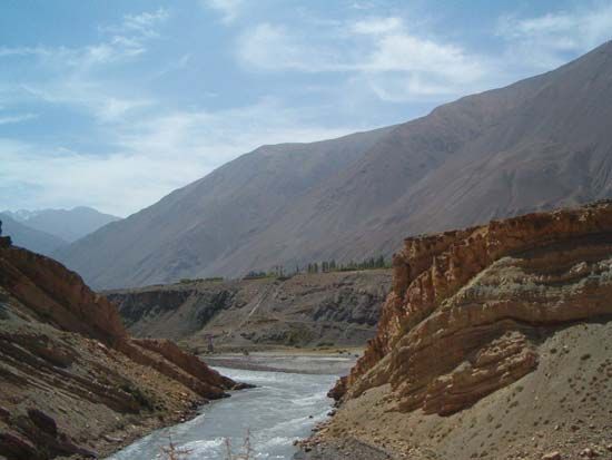
The Zeravshan River is a 545-mile (877-km) waterway that originates in the eastern Turkistan Range. It flows westward through Tajikistan and southeastern Uzbekistan before terminating in the desert north of Chärjew, near the Amu Darya, of which it was historically a tributary.1
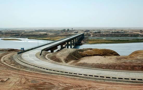
The river is vital to the region, supporting a densely populated valley and providing essential water to a vast irrigation district, including the Qarshi Steppe via a canal system. Additionally, the river’s geography is linked to regional infrastructure; for instance, the Zeravshan Highway serves as a key transportation route connecting the city of Samarkand with Chärjew in Turkmenistan.12
What is the Amu Darya river system?
The Amu Darya, historically known as the Oxus, is one of the longest and most significant river systems in Central Asia3.
River Course and Hydrology
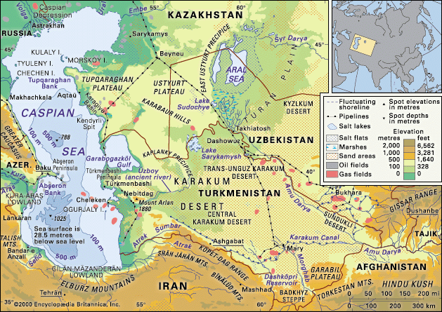
The river is formed by the confluence of the Vakhsh and Panj rivers in the mountains of Tajikistan. From this junction, it flows west-northwest, forming part of the border between Afghanistan and its northern neighbors before crossing the arid Turan Plain and the Karakum and Kyzylkum deserts.3
The basin is hydrologically divided into a mountainous “zone of nourishment,” fed by glaciers and snowmelt in the Pamirs and Hindu Kush, and a lowland “zone of depletion,” where the river loses significant volume to evaporation, seepage, and intensive irrigation.3
Environmental Impact
Historically, the Amu Darya discharged into the Aral Sea. However, large-scale water diversion for agriculture—particularly for cotton cultivation—began in the mid-20th century. This has led to:34
- Shrinking of the Aral Sea: The river no longer reaches its historic terminus, contributing to the sea’s catastrophic decline in volume and surface area.35
- Soil Degradation: Increased irrigation has caused intense salinization, rendering vast areas of land infertile.35
- Ecological Collapse: The depletion and pollution of the lower reaches have devastated local wildlife and the regional fishing industry.35
How does irrigation impact life in Central Asian deserts?
Irrigation is essential to life in the arid regions of Central Asia, where it has transformed vast desert landscapes into productive agricultural zones. However, this reliance on water diversion has profoundly altered the environment and human health in the region.374
Agricultural Transformation
Central Asia experiences very dry climatic conditions with sparse rainfall, making the Amu Darya and Syr Darya river systems the primary water sources for the region. Since the mid-20th century, large-scale irrigation projects—most notably for cotton cultivation—have enabled intensive agriculture in areas that were previously unsuitable for farming.784
Environmental and Health Consequences
The intensive diversion of river water has led to severe ecological consequences, most notably the catastrophic shrinking of the Aral Sea:8910
- Ecological Collapse: As the rivers no longer reach their historic terminus, the Aral Sea has lost the vast majority of its volume and surface area, destroying local fishing industries and devastating wildlife.8911
- Soil Degradation: Evaporation on hot, dry floodplains leaves behind salt deposits, causing intense salinization that renders soil infertile.89
- Public Health Crisis: Windstorms carry toxic dust—contaminated with salt, pesticides, and fertilizers from the exposed seabed—across the region. This has resulted in high rates of diseases, including throat cancers, anemia, and kidney disorders, among local populations.31049
What is the significance of the city of Samarkand in the Zeravshan Valley?
Samarkand is a city of profound historical and cultural significance located in the Zeravshan Valley of south-central Uzbekistan. As one of the oldest cities in Central Asia, its importance was primarily derived from its strategic position at the junction of ancient Silk Road trade routes connecting China and India.1516
Throughout its history, Samarkand served as a major political and intellectual hub. It was the capital of Sogdiana and later became the imperial capital under Timur, who transformed it into a premier economic and cultural center. The city is renowned for its Central Asian architecture, featuring iconic monuments such as the Rīgestān Square and the Gūr-e Amīr mausoleum. It also became a center for scientific advancement, notably through the observatory founded by the astronomer Ulūgh Beg. Designated a UNESCO World Heritage site in 2001, the city remains a vital agricultural and industrial center today.1516
Sources
- Zeravshan River — Encyclopædia Britannica
- Uzbekistan - Transportation — Encyclopædia Britannica
- Amu Darya — Encyclopædia Britannica
- Uzbekistan - Drainage — Encyclopædia Britannica
- Aral Sea: Top Questions — Encyclopædia Britannica
- Panj River — Encyclopædia Britannica
- land reclamation - Reclamation of arid land — Encyclopædia Britannica
- Aral Sea — Encyclopædia Britannica
- 6 Lakes That Are Drying Up - Aral Sea — Encyclopædia Britannica
- Asia - Groundwater — Encyclopædia Britannica
- Asia - Human impact on natural landscapes — Encyclopædia Britannica
- Asia - Agricultural technology — Encyclopædia Britannica
- Tajikistan - Agriculture — Encyclopædia Britannica
- Central Asia — Encyclopædia Britannica
- Samarkand — Encyclopædia Britannica
- Uzbekistan: Top Questions — Encyclopædia Britannica
- Samarkand rug — Encyclopædia Britannica
Published on · 3 min read