Boston Mountains
The Boston Mountains are a rugged mountain range extending approximately 200 miles (320 km) across northwestern Arkansas and northeastern Oklahoma. As the…
What is Boston Mountains?
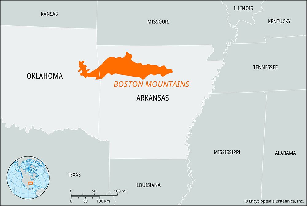
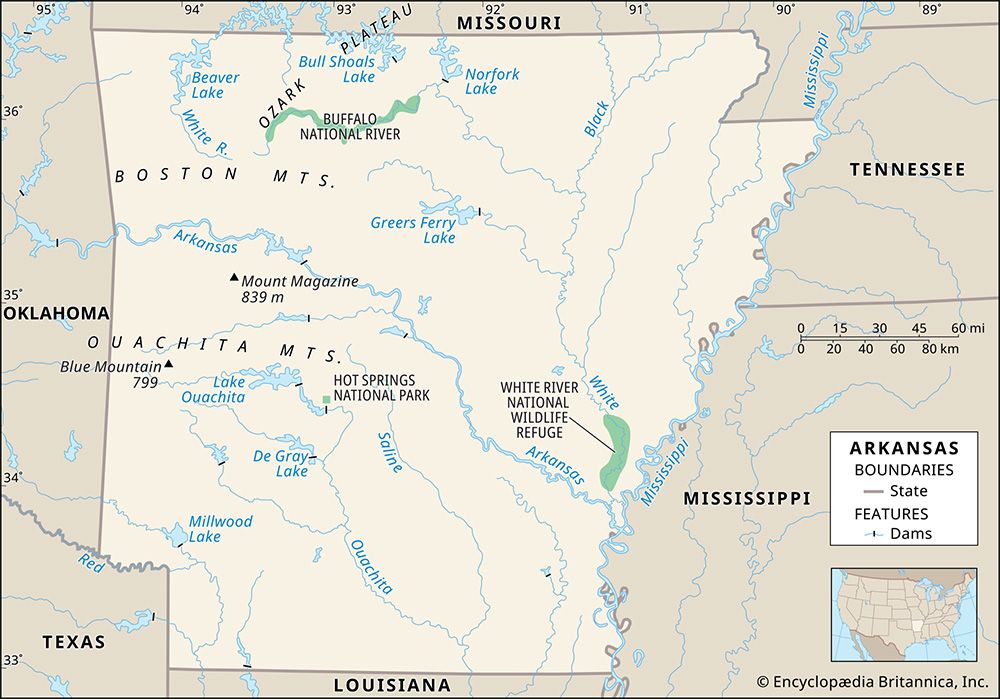
The Boston Mountains are a rugged mountain range extending approximately 200 miles (320 km) across northwestern Arkansas and northeastern Oklahoma. As the highest section of the Ozark Mountains, they are characterized by steep, gorgelike valleys and broad, flat-topped ridges.12
Several peaks within the range, such as Turner Ward Knob and Brannon Mountain, exceed 2,400 feet (730 meters) in elevation. The region is bounded by the Arkansas River and the White River, the latter of which has its source within the mountains. The area is home to significant natural sites, including a division of the Ozark National Forest, the Buffalo National River, and Devil’s Den State Park.1
What makes the Ozark Mountains different from other mountain ranges?
The Ozark Mountains are distinct primarily because they, along with the adjacent Ouachita Mountains, represent the only large area of rugged topography located between the Appalachians and the Rockies.1
Several key characteristics define the region:
- Topography: Often referred to as the Ozark Plateau, the region is an eroded tableland. While it is called a mountain range, its landscape is defined by broad, flat-topped ridges and deep, gorgelike valleys, particularly in the Boston Mountains section.56
- Hydrology: The region is uniquely characterized by an abundance of underground streams and springs, which play a significant role in the area’s drainage.1
- Ecology: The highlands are heavily forested, primarily with oak and hickory hardwoods, distinguishing them from the mixed pine and hardwood forests found in the nearby Ouachitas.7
How do rivers like the Buffalo National River shape the landscape?
Rivers are the primary agents in molding the Earth’s surface, transforming nondescript geologic settings into distinct topographic forms through the processes of erosion and deposition. While some landforms are created by tectonic or volcanic activity, rivers are ubiquitous, ensuring that fluvial processes shape landscapes globally.9
The Formation of Valleys and Canyons
Most valleys, including deep canyons and gorges, are created by the rivers that flow through them. As a river expends energy, it performs vertical entrenchment, which typically results in narrow, deep valleys—especially when cutting through resistant rock types. Over time, as a river approaches its baselevel, its energy shifts from vertical downcutting to lateral erosion. This process gradually widens the valley floor, causing the landscape to evolve from narrow, steep-walled forms to broader, more expansive valleys.1011
Influencing Factors
The final shape of a landscape is a result of the interaction between geology, the specific fluvial processes at work, and the amount of time these forces have been operating. Valley morphology is also strongly influenced by:9
- Bedrock composition: Harder, silica-rich rocks resist erosion, maintaining steeper profiles longer.11
- Geologic structures: Folds and faults can dictate the orientation and character of a valley.11
- Sediment load: The amount of sediment a river carries affects where incision occurs, often forcing the river to shift its path within the valley.10
What are the main differences between the Ozark Mountains and the Ouachita Mountains?
The Ozark Mountains and the Ouachita Mountains are distinct physiographic regions separated by the Arkansas River valley. While both represent significant rugged highlands between the Appalachians and the Rockies, they differ in several key ways:73
Geological Structure and Topography
- Ozark Mountains: Primarily an eroded tableland or plateau, the region features broad, flat-topped ridges and deep valleys. The northern sections, such as the Springfield and Salem plateaus, are characterized by gently rolling landscapes and extensive underground drainage, including limestone caves and springs.73
- Ouachita Mountains: This range consists of eroded, folded, and faulted rocks. The landscape is defined by a series of parallel ridges that trend east-west and maintain relatively uniform heights.78
Vegetation
Sources
- Boston Mountains — Encyclopædia Britannica
- Boston Mountains — Merriam-Webster
- Arkansas - Relief, drainage, and soils — Encyclopædia Britannica
- Boston - Landscape — Encyclopædia Britannica
- Ozark Mountains — Encyclopædia Britannica
- Ozark Plateau — Merriam-Webster
- Ouachita Mountains — Encyclopædia Britannica
- Arkansas - Plant and animal life — Encyclopædia Britannica
- river - Rivers as agents of landscape evolution — Encyclopædia Britannica
- river - Valleys and canyons — Encyclopædia Britannica
- river - Valley evolution — Encyclopædia Britannica
Published on · 3 min read