Carbet Mountains
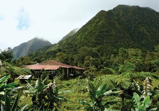
The Carbet Mountains are a volcanic mountain mass located in the center of the Caribbean island of Martinique, part of the Lesser Antilles.
What is Carbet Mountains?
The Carbet Mountains are a volcanic mountain mass located in the center of the Caribbean island of Martinique, part of the Lesser Antilles.12
Situated between the towns of Saint-Pierre and Fort-de-France, this highland extends approximately 50 miles (80 km) from northwest to southeast. The range features several notable peaks, including Lacroix (3,924 feet/1,196 meters), Piquet (3,806 feet/1,160 meters), and others such as Dumauzé, Alma, and Boucher.1
The mountains serve as a vital hydrological center for the island, with rivers flowing outward in a starlike pattern, including the Lorrain, Galion, Capot, and Lézarde rivers. Additionally, the range is the source of water for the hot springs found in the town of Absalon. In 1932, an observatory was established in the area to monitor the nearby Mount Pelée.21
What is the significance of Mount Pelee in Martinique?
Mount Pelée is a significant active volcanic mountain located in northern Martinique, rising to an elevation of 4,583 feet (1,397 meters). Its significance is primarily defined by its catastrophic eruption on May 8, 1902, which destroyed the port city of Saint-Pierre Saint-Pierre](https://www.britannica.com/place/Saint-Pierre-Martinique).345
The 1902 eruption resulted in the deaths of approximately 30,000 people—roughly 15 percent of the island’s population at the time—leaving only two survivors in the city. This event was so profound that it introduced the term pelean into geological science, used to describe volcanic eruptions characterized by the release of ash, gas, and deadly nuée ardente (a “fiery cloud” or pyroclastic flow).35
Beyond its destructive history, the mountain remains a subject of scientific study, with an observatory established in the region to monitor its activity. The name “Pelée,” meaning “Bald,” reflects its composition of volcanic ash and lava layers, which support luxuriant forests despite the mountain’s history of eruptions.23
How do volcanic mountains influence island ecosystems?
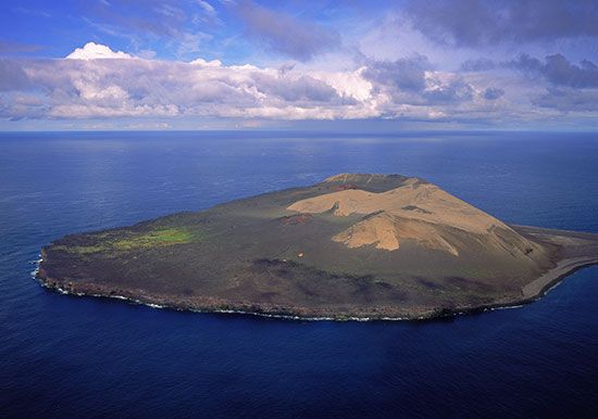
Volcanic mountains play a transformative role in shaping island ecosystems, acting as both creators of new land and long-term providers of environmental resources.
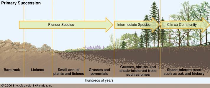
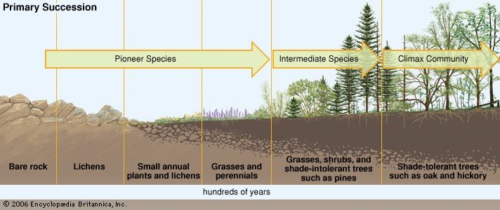
Primary Succession
Volcanic activity often creates barren, lifeless landscapes, such as cooled lava flows. These areas undergo primary succession, where pioneer species—such as lichens and fast-growing grasses—first colonize the rock. As these organisms die and decompose, they create the initial pockets of soil necessary for more complex plant and animal life to establish themselves, eventually leading to a balanced climax community.7
Soil Fertility and Agriculture
Over time, volcanic ash weathers to form rich, loamy soils that are highly conducive to plant growth. This fertility is a defining feature of many volcanic islands, such as Java, where volcanic soil supports dense populations through intensive agriculture, contrasting sharply with non-volcanic islands that may have less productive land.89
Climate and Hydrology
Volcanic mountains also influence local climates and ecosystems through the “thermal mountain effect,” where air forced over elevated terrain or heated island surfaces generates convective currents and precipitation. Furthermore, high-altitude volcanic peaks can significantly impact global climate by injecting aerosols into the stratosphere, which may temporarily lower temperatures.108
What are the other major mountain massifs in Martinique?
Martinique’s mountainous terrain is defined by three principal massifs that shape the island’s geography and drainage patterns. Beyond the active volcano Mount Pelée in the north, the other major massifs are:
- Carbet Mountains: Located in the center of the island, this volcanic mountain mass extends in a northwest to southeast direction. Its highest peaks include Lacroix (3,924 feet/1,196 meters), Piquet (3,806 feet/1,160 meters), and several others exceeding 3,500 feet, such as Dumauzé, Alma, and Boucher. These mountains serve as a vital watershed, with rivers flowing outward in a starlike pattern, and they are the source of water for the hot springs at Absalon.12
- Mount Vauclin: Situated in the south, this massif is significantly lower than the northern and central peaks, rising to an elevation of 1,654 feet (504 meters). It serves as the source for the Salée and Pilote rivers.2
Sources
- Carbet Mountains — Encyclopædia Britannica
- Martinique - Relief and drainage — Encyclopædia Britannica
- Mount Pelée — Encyclopædia Britannica
- Saint-Pierre — Encyclopædia Britannica
- world’s major volcanoes — Encyclopædia Britannica
- Pelée, Mount — Merriam-Webster
- primary succession — Encyclopædia Britannica
- Hawaii - Relief — Encyclopædia Britannica
- volcanism — Encyclopædia Britannica
- volcano - Submarine volcanoes — Encyclopædia Britannica
- volcano - Long-term environmental effects — Encyclopædia Britannica
- Cook Islands - Soils — Encyclopædia Britannica
- weather modification - Changes in the radiation balance near the ground — Encyclopædia Britannica
- Hawaii - Soils — Encyclopædia Britannica
- community ecology - Biogeographic aspects of diversity — Encyclopædia Britannica
- volcano - Determinants of size and shape — Encyclopædia Britannica
Published on · 3 min read