Dnieper River
The construction of dams and reservoirs along the Dnieper River has fundamentally transformed its natural hydrology and ecology to support industrial and…
How have dams and reservoirs on the Dnieper River affected its flow and surrounding areas?
The construction of dams and reservoirs along the Dnieper River has fundamentally transformed its natural hydrology and ecology to support industrial and agricultural development.1
Hydrological and Ecological Impacts
The damming of the river has significantly altered its natural flow regime. By reducing seasonal flow variations, the dams have stabilized water levels for navigation, but they have also caused the annual outflow of the river to decrease by approximately 20 percent due to evaporation from reservoirs and water diversion for irrigation. Furthermore, the dams have created physical barriers that restrict upstream access for anadromous fish, while pollution from industrial, urban, and agricultural runoff has severely damaged the river’s estuary and surrounding wetlands.1
Economic and Regional Benefits
These projects have provided critical solutions for the region:
- Navigation: A continuous deepwater route now connects the Pripet River to the Black Sea.1
- Energy: Large-scale hydroelectric power stations, such as the one at Zaporizhzhya, provide significant energy capacity.1
- Water Supply: Reservoirs support irrigation for arid lands in southern Ukraine and Crimea, and provide essential water to industrial hubs like Kryvyy Rih and the Donets Basin.1
What is the geographical location and course of the Dnieper River?
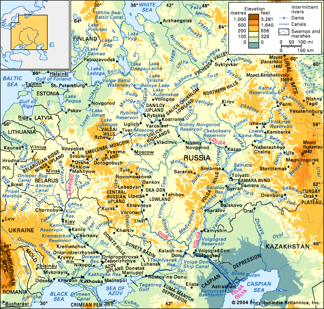
The Dnieper River is a major European waterway, ranking as the continent’s fourth-longest river. It spans 1,367 miles (2,200 km) and drains a vast watershed of approximately 195,000 square miles.4
Geographical Course
The river originates in a peat bog within the Valdai Hills of Russia, roughly 150 miles west of Moscow. Its course is generally southerly, traversing three countries:
- Russia: It flows through the Smolensk region.4
- Belarus: The river travels south through Belarusian territory for about 370 miles.4
- Ukraine: It continues south to Kiev, turns southeast toward Dnipropetrovsk, and finally flows south-southwest to the Black Sea.4
Physiographic Divisions
The river is traditionally categorized into three sections:
- Upper Dnieper: From the source to Kiev, characterized by excessive moisture, swampy banks, and dense river networks.2
- Middle Dnieper: From Kiev to Zaporizhzhya, featuring a distinct asymmetrical valley with a high, steep right bank.2
- Lower Dnieper: From Zaporizhzhya to the mouth, passing through the Black Sea Lowland and forming a delta at the estuary.2
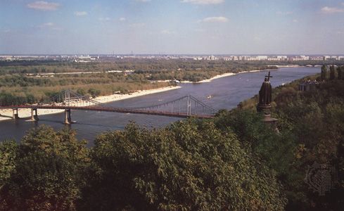
What historical significance does the Dnieper River hold for the countries it flows through?
The Dnieper River has served as a vital artery for eastern Europe since ancient times, playing a foundational role in the development of the early Kievan state.1
Historical and Cultural Significance
- Trade Routes: Between the 4th and 6th centuries CE, the river became the core of the “route from the Varangians to the Greeks.” This system connected the Black Sea to the Baltic Sea, facilitating essential cultural and economic exchanges between the Slavs and Mediterranean and Baltic peoples.1
- National Symbolism: For the Ukrainian people, the Dnieper holds profound significance as a national symbol, comparable to the status of the Volga River for the Russian people.1
- Early Documentation: The river’s importance is reflected in its long history of documentation, appearing in the works of the Greek historian Herodotus in the 5th century BCE, as well as writings by Strabo and Pliny the Younger. It was first mapped by Ptolemy in the 2nd century CE.1
What environmental challenges does the Dnieper River face in modern times?
The Dnieper River faces significant environmental challenges primarily due to extensive human intervention and industrial exploitation. The construction of numerous dams and reservoirs has radically altered the river’s natural hydrology and ecology, leading to a 20 percent reduction in its annual outflow.1
Key environmental issues include:
- Ecological Disruption: The damming of the river has reduced seasonal flow variations and obstructed upstream access for anadromous fish, while reservoirs have inundated vast territories, damaging natural habitats.1
- Pollution: The river suffers from significant contamination caused by industrial chemical wastes, untreated municipal sewage, and agricultural runoff. These effluents have severely degraded water quality and damaged the wetlands around the river’s estuary.1
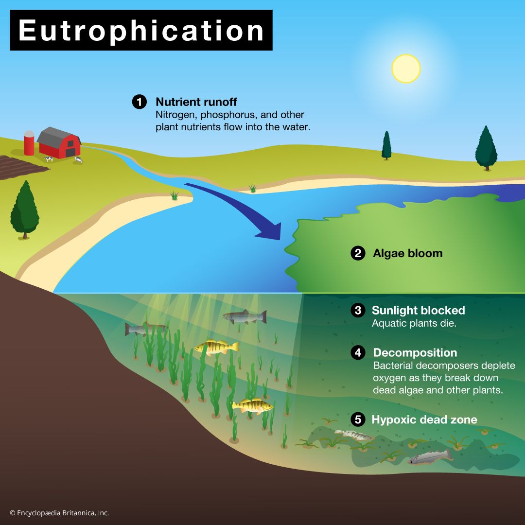
- Eutrophication: Increased levels of phosphates and nitrates from fertilizers promote rapid algal growth. The subsequent decay of these blooms depletes oxygen levels in the water, harming aquatic life and rendering the water unfit for consumption without specialized treatment.2
- Habitat Loss: The reduction of discharge and ongoing pollution have caused serious damage to the river’s delta and surrounding ecosystems.1
Sources
- Dnieper River - History and economy — Encyclopædia Britannica
- Dnieper River - Physiography — Encyclopædia Britannica
- Dnieper River - Hydrology of the Dnieper River — Encyclopædia Britannica
- Dnieper River — Encyclopædia Britannica
- Dnipro — Encyclopædia Britannica
- river - Environmental problems attendant on river use — Encyclopædia Britannica
Published on · 3 min read