How Are Mountains Formed?
Mountains are primarily created by tectonic processes, which involve the uplift or movement of the Earth's crust. These "builder" processes occur through…
How are mountains formed?
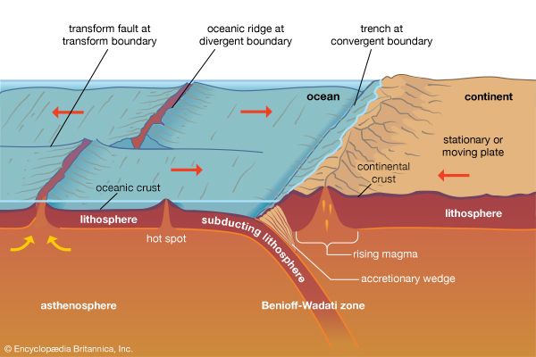
Mountains are primarily created by tectonic processes, which involve the uplift or movement of the Earth’s crust. These “builder” processes occur through several key mechanisms:
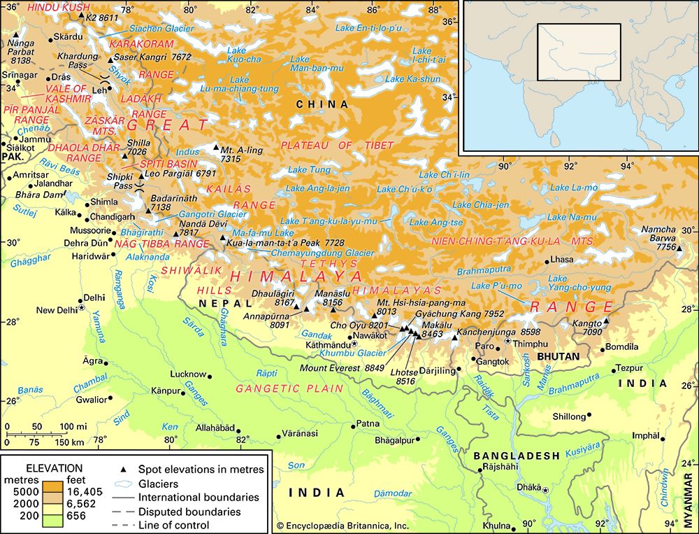
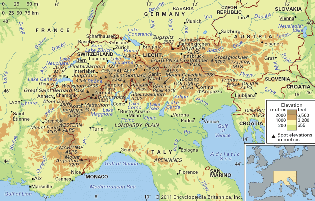
- Collisional Uplift: When lithospheric plates collide, they can cause crustal shortening and thickening. This includes the continent-continent collision type, which formed ranges like the Himalayas and the Alps, as well as subduction-related collisions that create volcanic chains like the Andes.
- Folding and Thrusting: Horizontal forces compress rock layers, creating folds (undulations) and thrusting older rock over younger strata, forming fold belts.123
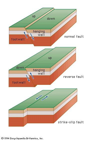
- Block Faulting: When crustal blocks are pulled apart or pushed up, they form block-fault mountains. This process can create steep ranges and intervening basins.42
- Volcanism: Mountains also form through the accumulation of volcanic rock erupted onto the surface, such as shield volcanoes or stratovolcanoes.15
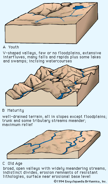
While tectonic forces build these structures, erosion continuously sculpts their final appearance, eventually reducing their elevation over millions of years.12
How does erosion change the shape of mountains over time?
Erosion acts as a powerful force that continuously wears down and reshapes mountains, working in opposition to the tectonic processes that build them. While tectonic forces create high elevations, erosion gradually reduces these differences in height through several mechanisms.8910
Mechanisms of Change
- Fluvial and Atmospheric Action: Moving water, rain, and frost break down rock and transport debris away from mountain slopes. This process often highlights differences in rock resistance; for example, harder, more resistant rocks may remain as ridges, while weaker rocks are carved into valleys.101
- Glacial Processes: Glaciers act as massive abrasive systems. Through abrasion (grinding the surface with embedded debris) and plucking (removing large rock fragments), glaciers carve out sharp peaks, steep-sided valleys, and deep basins.1112
- Wind Erosion: In arid environments, wind-driven sand acts as a natural abrasive, wearing down landforms through sandblasting and removing loose particles via deflation.10
- Mass-Wasting: Gravity-driven movements, such as landslides and rockfalls, rapidly transport material down slopes, contributing to the overall degradation of mountain mass.210
Over millions of years, these processes can reduce even the most massive mountain ranges to low-lying residual mountains.91
What is the difference between a mountain range and a plateau?
While both mountains and plateaus are elevated landforms, they are distinguished primarily by their surface relief and topography.
Key Differences
- Surface Relief: A mountain is defined by its prominent rise above surrounding terrain, characterized by steep slopes, confined summits, and significant local relief. In contrast, a plateau is an extensive upland area defined by its remarkably flat surface and low relative relief, even when situated at high altitudes.1415
- Structure: Mountains typically occur in elongated chains or ranges connected by ridges and separated by valleys. Plateaus are often bounded by steep escarpments on their sides, though they can sometimes be enclosed by mountain ranges.1415
- Geologic Context: While both can be formed by volcanism, crustal shortening, and thermal expansion, their resulting topographies differ significantly. Mountains are characterized by their jagged, vertical nature, whereas plateaus maintain a broad, level horizon.161514
It is important to note that these features are not mutually exclusive; plateaus can exist within larger mountain belts, such as the Altiplano located within the Andes.1514
How do scientists determine the age of a mountain range?
Scientists determine the age of a mountain range by integrating two primary approaches: relative dating and absolute (radiometric) dating. Because mountain building involves complex geologic events, geologists often use these methods in tandem to construct a reliable timeline.1920
Relative Dating
Relative dating establishes the sequence of events without providing a specific numerical age. It relies on fundamental principles of geochronology:
- Principle of Superposition: In undisturbed sedimentary sequences, older layers are found at the base, while younger layers accumulate on top.2120
- Crosscutting Relationships: Any geologic feature—such as a fault, dike, or igneous intrusion—that cuts across existing rock units must be younger than the rocks it disrupts.20
- Fossil Correlation: By studying the fossil content within rock strata, scientists can correlate sequences across different regions to determine their relative ages.1921
Absolute Dating
To assign numerical ages, scientists use radiometric dating. This method measures the decay of radioactive isotopes (such as uranium, potassium, or rubidium) into stable daughter products at a known, constant rate. By analyzing the ratio of parent to daughter atoms in minerals, researchers can calculate the time elapsed since the rock or mineral formed. In metamorphic or igneous rocks common in mountain roots, scientists can even date specific growth stages of minerals to pinpoint the timing of deformation or melting events.192220
Sources
- tectonic landform — Encyclopædia Britannica
- continental landform - Orogenic geomorphic systems — Encyclopædia Britannica
- plate tectonics - Mountain building — Encyclopædia Britannica
- volcano - Determinants of size and shape — Encyclopædia Britannica
- mountain - Geomorphic characteristics — Encyclopædia Britannica
- fold mountain — Merriam-Webster
- fold — Encyclopædia Britannica
- mountain - Tectonic processes that create and destroy mountain belts and their components — Encyclopædia Britannica
- glacier - Glacier hydrology — Encyclopædia Britannica
- glacial landform - Glacial erosion — Encyclopædia Britannica
- glacial landform - Erosional landforms of valley glaciers — Encyclopædia Britannica
- mass-wasting — Merriam-Webster
- erosion — Encyclopædia Britannica
- plateau — Encyclopædia Britannica
- plateau — Merriam-Webster
- mountain - Residual mountain ranges and thermally uplifted belts — Encyclopædia Britannica
- plateau - Formative processes — Encyclopædia Britannica
- mountain — Encyclopædia Britannica
- dating: Top Questions — Encyclopædia Britannica
- geochronology — Encyclopædia Britannica
- dating - Principles of isotopic dating — Encyclopædia Britannica
- dating - Determination of sequence — Encyclopædia Britannica
- plate tectonics - Mountains by subduction — Encyclopædia Britannica
Published on · 4 min read