Queen Alexandra Range
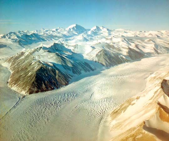
The Queen Alexandra Range is a prominent mountain range located in the Ross Dependency of Antarctica, situated along the western edge of the Ross Ice Shelf.
What is Queen Alexandra Range?
The Queen Alexandra Range is a prominent mountain range located in the Ross Dependency of Antarctica, situated along the western edge of the Ross Ice Shelf.1
Key features of the range include:
- Elevation: It reaches its highest point at Mount Kirkpatrick, which stands at 14,856 feet (4,528 meters).1
- Geography: The range is positioned between the Dry Valleys and the Queen Maud Range, separated from the latter by the Beardmore Glacier.1
- Geology: It contains areas of peneplain formed by historical erosion and features peaks like Mount Falla, which is topped by 14 distinct layers of basaltic lava.1
- History: The range was discovered in 1908 by the British explorer Ernest Shackleton and named in honor of Queen Alexandra of England.1
Who was Ernest Shackleton and what were his Antarctic expeditions?
Sir Ernest Henry Shackleton (1874–1922) was an Anglo-Irish explorer celebrated for his leadership and perseverance during the “heroic age” of Antarctic exploration. He participated in or led four major expeditions:2
- Discovery Expedition (1901–04): Serving under Robert Falcon Scott, Shackleton took part in a sledge journey across the Ross Ice Shelf before illness forced his return home.2
- Nimrod Expedition (1907–09): As leader, Shackleton established a base on Ross Island. His team achieved the first ascent of Mount Erebus, reached the south magnetic pole, and came within 97 nautical miles of the geographic South Pole before turning back due to dwindling supplies.23
- Imperial Trans-Antarctic Expedition (1914–16): Shackleton attempted to cross the continent. After his ship, the Endurance, was crushed by pack ice, he led his crew to safety through a harrowing journey to South Georgia, ensuring the survival of every member Georgia](https://www.britannica.com/place/South-Georgia), ensuring the survival of every member.2
- Shackleton-Rowett Expedition (1921–22): Shackleton aimed to circumnavigate the continent aboard the Quest but died at the start of the journey in South Georgia.23
What is the significance of the Beardmore Glacier in Antarctic exploration?
The Beardmore Glacier is one of the world’s largest valley glaciers, spanning 125 miles in length and 25 miles in width, and serves as a critical geographic link between the South Polar Plateau and the Ross Ice Shelf.5
Its significance in Antarctic exploration is defined by its role as a primary route for early expeditions seeking the South Pole:
- Exploration Route: The glacier was discovered by Ernest Shackleton in 1908 during his attempt to reach the South Pole. It was later utilized by Robert Falcon Scott during his 1911–12 expedition. Tragically, Scott’s party perished on the Ross Ice Shelf after their return journey via this route.54
- Scientific Discovery: Beyond its role in navigation, the glacier and its surrounding Transantarctic Mountains have provided invaluable geological evidence. Researchers have discovered petrified wood and fossils of dinosaurs, ferns, and coral, proving that Antarctica once possessed a temperate climate.5
We could dive deeper into the specific geological findings from the region or compare the different routes taken by early polar explorers.
How do mountain ranges form in Antarctica?
Mountain ranges in Antarctica have formed through complex, long-term geologic processes involving plate tectonics and ancient mountain-building episodes.78
The formation of these ranges is generally characterized by the following:
- Crustal Deformation: Over hundreds of millions of years, ancient marine and lake basins were filled with volcanic and sedimentary debris. During periods of intense tectonic activity, these materials were deformed and recrystallized deep within the Earth’s crust to create crystalline-rock complexes.7
- Uplift and Erosion: Following these deep-crustal transformations, the rocks were uplifted to the surface, where they were further sculpted by erosion to form mountain chains.7
- Structural Provinces: Antarctica is divided into distinct structural regions. East Antarctica is a stable, ancient shield, while West Antarctica is a younger mobile belt. The Transantarctic Mountains act as a massive fault-block belt, or horst, separating these two provinces.7
- Volcanic Activity: Some Antarctic ranges, particularly in West Antarctica and the Antarctic Peninsula, have been shaped by volcanic processes, resulting in chains of volcanoes similar to those found along the Pacific rim.9
Sources
- Queen Alexandra Range — Encyclopædia Britannica
- Ernest Shackleton: Top Questions — Encyclopædia Britannica
- Ernest Shackleton — Encyclopædia Britannica
- Antarctica - Discovery of the Antarctic poles — Encyclopædia Britannica
- Beardmore Glacier — Encyclopædia Britannica
- Beardmore — Merriam-Webster
- Transantarctic Mountains — Encyclopædia Britannica
- Antarctica - Structural framework — Encyclopædia Britannica
- Antarctica - Antarctica and continental drift — Encyclopædia Britannica
- Antarctica - Relief — Encyclopædia Britannica
- Gamburtsev Mountains — Encyclopædia Britannica
Published on · 3 min read