Somali Basin
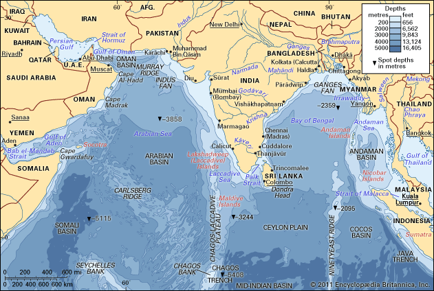
The Somali Basin is a submarine basin located on the floor of the southwestern Arabian Sea, an arm of the Indian Ocean situated east of Somalia.
What is Somali Basin?
The Somali Basin is a submarine basin located on the floor of the southwestern Arabian Sea, an arm of the Indian Ocean situated east of Somalia.1
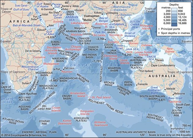
It is separated from the shallower Arabian Basin to the northeast by the Carlsberg Ridge, a seismically active submarine ridge. To the south, the Somali Basin connects with the Mascarene and Madagascar basins. The region is characterized by a large abyssal plain located off the Somali coast.12
Geologically, the basin floor features deposits of red clay at depths exceeding 13,000 feet (4,000 meters). Additionally, researchers have discovered authigenic ferromanganese nodules within the basin. The continental shelf along the adjacent Somali coast is notably narrow.2
What is the Carlsberg Ridge and how does it affect the Indian Ocean floor?
The Carlsberg Ridge is a significant submarine ridge located in the Indian Ocean and the Arabian Sea. It serves as a structural boundary, separating the Arabian Sea to the northeast from the Somali Basin to the southwest. While sometimes categorized as a distinct feature, it is often identified as the northern segment of the Mid-Indian Ridge, which is part of the global oceanic ridge system.45
Regarding its impact on the ocean floor, the ridge is a primary site of plate tectonics activity. It coincides with a major belt of seismic activity, characterized by frequent earthquake epicenters. This tectonic movement results in a rugged, rough relief and a notably thin layer of sediment cover across the ridge. Extending from a triple junction of tectonic plates to the Gulf of Aden, the ridge provides a continuous link to the East African Rift System.45
What are abyssal plains and how are they formed?
An abyssal plain is a vast, remarkably flat area of the deep ocean floor, typically found at depths between 3,000 and 6,000 meters (10,000 to 20,000 feet). These plains are generally located adjacent to continental margins and are most common in the Atlantic Ocean.6
Formation
Abyssal plains are formed through the accumulation of land-derived sediment that fills in and smooths out the preexisting, irregular topography of the ocean floor, such as abyssal hills. This process occurs primarily through:
- Turbidity Currents: These are dense, sediment-laden slurries that flow down continental slopes due to gravity. When these currents reach the deep ocean floor, they deposit layers of silt, sand, and gravel, effectively burying the rugged landscape beneath them.67
- Pelagic Sedimentation: Between turbidity-current events, fine-grained clay and the microscopic remains of marine organisms settle slowly through the water column, accumulating at a rate of only a few millimeters per millennium.6
Over time, these combined deposits create a thick, level surface, though isolated volcanic hills may still protrude through the sediment in some areas.6
How do tectonic plate movements shape the floor of the Arabian Sea?
Tectonic plate movements have profoundly shaped the floor of the Arabian Sea over the past 50 million years, primarily driven by the collision of the Indian subcontinent with Asia.2
Key tectonic features and processes include:
- Mid-Ocean Ridges: The Carlsberg Ridge acts as a central structural boundary, dividing the sea into the Arabian Basin and the Somali Basin. As part of the global oceanic ridge system, it is a site of seafloor spreading where molten material from the mantle wells up, creating new crust and rugged, seismically active terrain.21011
- Subduction Zones: West of the Murray Ridge, the Malian subduction zone marks an area where the ocean floor is forced downward beneath the continental crust.2
- Rifting and Compression: The northward rotation of the Arabian plate has caused significant compression. This movement has pushed oceanic crust onto the Arabian plate to form the mountains of Oman and contributed to the formation of the Zagros Mountains in Iran. Additionally, rift faults in the Gulf of Aden connect to the East African Rift System, further defining the region’s complex geology.122
Sources
- Somali Basin — Encyclopædia Britannica
- Arabian Sea - Submarine morphology and geology — Encyclopædia Britannica
- Somalia - Drainage — Encyclopædia Britannica
- Carlsberg Ridge — Encyclopædia Britannica
- Mid-Indian Ridge — Encyclopædia Britannica
- abyssal plain — Encyclopædia Britannica
- abyssal plain — Merriam-Webster
- turbidity current — Encyclopædia Britannica
- abyssal hill — Encyclopædia Britannica
- Indian Ocean - Oceanic ridges and fracture zones — Encyclopædia Britannica
- Arabian Basin — Encyclopædia Britannica
- seafloor spreading — Encyclopædia Britannica
- Arabian Desert - Geology of the Arabian Desert — Encyclopædia Britannica
Published on · 3 min read