The Bahamas
The influence of the native Lucayan people on modern Bahamian culture is primarily linguistic and historical, as the Lucayan population was decimated by…
How has the native Lucayan population influenced modern Bahamian culture?
The influence of the native Lucayan people on modern Bahamian culture is primarily linguistic and historical, as the Lucayan population was decimated by Spanish raiders shortly after European contact.12
The most direct legacy is the name of the country itself; “Bahamas” is derived from the Lucayan Taino language, specifically the Arawakan term for the islands. Beyond this, the Lucayans—who settled the archipelago by 800 CE—are remembered as the original inhabitants who encountered Christopher Columbus during his 1492 landfall.12
While modern Bahamian culture is described as a distinctive blend of African and European heritages—shaped largely by the later slave trade and plantation systems—the tragic fate of the Lucayans remains a foundational, albeit somber, chapter in the nation’s history. Because the islands were left largely depopulated for over a century following the removal of the native inhabitants, there is little evidence of direct cultural continuity in daily social customs or traditions.132
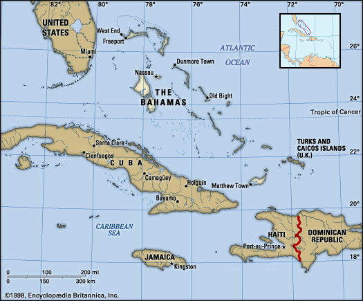
What are the major islands that make up The Bahamas archipelago?
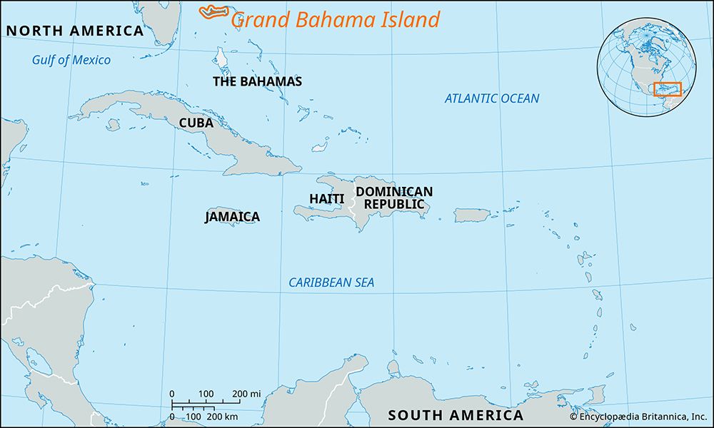
The Bahamas archipelago consists of nearly 700 islands and cays, along with more than 2,000 low, barren rock formations, stretching over 500 miles between Grand Bahama Island and Great Inagua Island. Only about 30 of these islands are permanently inhabited.78
Major islands and island groups include:
- Andros Island: The largest island in The Bahamas, covering approximately 2,300 square miles.7
- New Providence Island: The island containing the capital, which is distinct from the Out Islands (also known as the Family Islands)7.8
- Grand Bahama Island: Home to major settlements such as Freeport and West End.7
- Abaco: Also known as Great Abaco.7
- Eleuthera: Notable as the site of early colonization attempts.7
- Bimini Islands9
- Exuma Cays9
- San Salvador Island9
- Samana Cay9
What are the main economic activities and industries in The Bahamas?
The economy of The Bahamas is a market-based system characterized by a high gross national product (GNP) per capita and a heavy reliance on tourism and international financial services.10
Key Economic Sectors
- Tourism and Finance: Tourism is the primary economic driver, accounting for more than one-third of the GNP and employing roughly two-fifths of the workforce. The nation also serves as a major offshore financial hub, attracting hundreds of banks and trust companies due to the absence of corporate and income taxes and the guarantee of financial secrecy.11
- Manufacturing: Industrial activity is centered on the production of rum and other liquors. Other notable products include cement, pharmaceuticals, and the processing of canned fruits and frozen spiny lobster.12
- Agriculture and Fishing: Agriculture plays a minor role in the economy due to limited arable land and shallow soils, necessitating the import of most foodstuffs. The small fishing industry focuses primarily on spiny lobster, grouper, and conch.13
- Trade: The United States is the country’s most significant trading partner. Major exports include petroleum and rock lobster, while imports consist largely of machinery, transport equipment, food, and fuel.14
What is the geographical location and composition of The Bahamas?
The Bahamas is an archipelago and country situated on the northwestern edge of the West Indies, commanding the gateway to the Gulf of Mexico and the Caribbean Sea. It stretches more than 500 miles (800 km) southeast-northwest, lying north of Cuba and Hispaniola and east of the U.S. state of Florida.716
The archipelago is composed of nearly 700 islands and cays, along with more than 2,000 low, barren rock formations. Geologically, the islands occupy an irregular submarine tableland that rises from the Atlantic Ocean. Beneath the soil, the islands consist of limestone rock and the skeletal remains of coral fossils and other marine organisms. Topographically, they are characterized by extensive flatlands, with some islands featuring ranges of hills formed by sand dunes that have cemented into limestone. While there are no rivers, some islands contain large lakes, and Andros Island possesses abundant fresh water.161
Sources
- The Bahamas — Encyclopædia Britannica
- The Bahamas - Cultural life — Encyclopædia Britannica
- Lucayo — Merriam-Webster
- The Bahamas - Ethnic groups, languages, and religion — Encyclopædia Britannica
- The Bahamas - Daily life and social customs — Encyclopædia Britannica
- The Bahamas - History — Encyclopædia Britannica
- The Bahamas - Land — Encyclopædia Britannica
- list of islands - The Bahamas — Encyclopædia Britannica
- Out Islands — Encyclopædia Britannica
- The Bahamas - Services and finance — Encyclopædia Britannica
- The Bahamas - Agriculture and fishing — Encyclopædia Britannica
- The Bahamas - Economy of the The Bahamas — Encyclopædia Britannica
- The Bahamas - Trade — Encyclopædia Britannica
- The Bahamas - Transportation — Encyclopædia Britannica
- The Bahamas - Manufacturing — Encyclopædia Britannica
- The Bahamas - Relief and soils — Encyclopædia Britannica
- The Bahamas - British colonization — Encyclopædia Britannica
- The Bahamas: Country Facts — Encyclopædia Britannica
Published on · 3 min read