Turkistan Range
The Turkistan Range is a mountain range located across Kyrgyzstan, Tajikistan, and Uzbekistan. Branching from the Alay Mountains, it stretches 200 miles (320…
What is Turkistan Range?
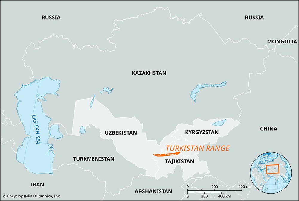
The Turkistan Range is a mountain range located across Kyrgyzstan, Tajikistan, and Uzbekistan. Branching from the Alay Mountains, it stretches 200 miles (320 km) in an east-west direction, situated between the Fergana and Zeravshan valleys.1
The range reaches its highest elevation at Piramidalny Peak, which stands at 18,077 feet (5,510 meters). Geologically, the mountains are composed primarily of sandstones, schists, and limestones. The northern slopes feature groves of trees below the snow line, while the southern slopes are steeper, drier, and largely lack vegetation. In Tajikistan, the Shakhristan Pass—located at 11,083 feet (3,378 meters)—serves as a vital crossing for the road connecting Ūroteppa and Dushanbe. The range runs parallel to the Zeravshan Range, which lies to the south.12
What is the significance of the Pamir Knot in Central Asian geography?
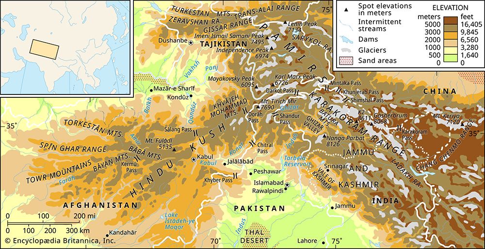
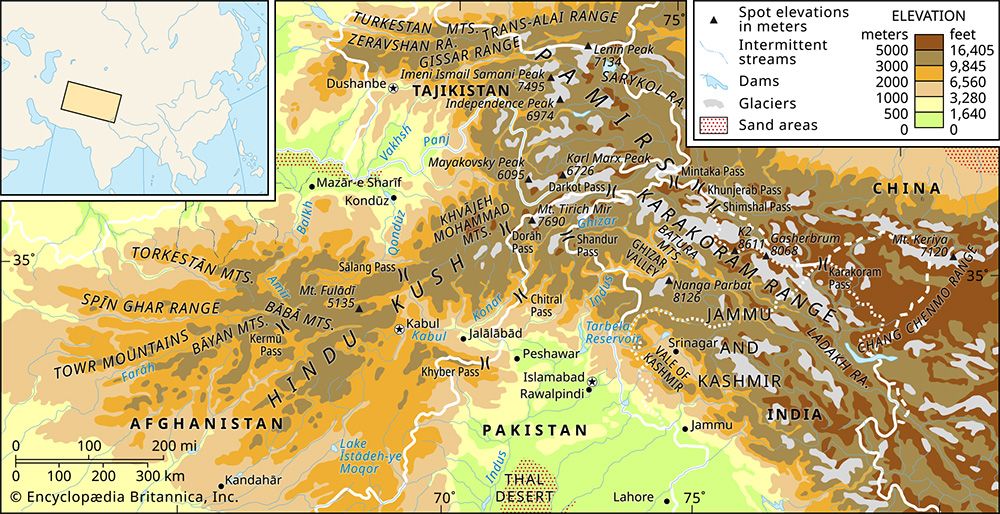
The Pamir Knot is a significant nodal orogenic uplift in Central Asia that serves as the structural heart of the region’s complex mountain systems. It acts as a central hub from which several major mountain ranges radiate, effectively linking the high-altitude landscapes of the continent. These radiating ranges include the Hindu Kush, the Karakoram Range, the Kunlun Mountains, and the Tien Shan.3
Geographically, this nodal point anchors the Pamirs, a vast highland region primarily located within Tajikistan, with fringes extending into Afghanistan, China, and Kyrgyzstan. By serving as the convergence point for these massive geological formations, the Pamir Knot plays a critical role in defining the topography and drainage patterns of the surrounding Central Asian territories.3
How do mountain ranges influence the climate of the surrounding valleys?
Mountain ranges significantly influence the climate of surrounding valleys by acting as physical barriers to atmospheric flow and altering local air circulation patterns.
Precipitation and the Rain Shadow Effect
When moist air encounters a mountain range, it is forced upward, causing it to cool and condense, which results in orographic precipitation on the windward slopes. As the air descends on the leeward side, it is compressed and warmed, which increases its capacity to hold moisture and leads to drier, hotter conditions. This region of reduced rainfall is known as a rain shadow of reduced rainfall is known as a rain shadow.56789
Wind and Temperature Dynamics
Mountains also modify wind climates through several mechanisms:
- Funneling: Valleys can accelerate regional wind flows.5
- Circulation: Mountains generate mesoscale mountain- and valley-wind circulations.5
- Cold Air Drainage: Cold air can drain from higher elevations into low-lying valleys, creating “frost pockets”.5
- Barrier Effects: Large mountain barriers can block the movement of cold air masses from continental interiors, often resulting in milder weather on the windward side compared to the interior.10
What are some other major mountain ranges found in Central Asia?
Central Asia is defined by a series of massive, interconnected mountain systems that serve as both physical barriers and vital watersheds. Beyond the Pamirs, several other major ranges dominate the region’s topography:
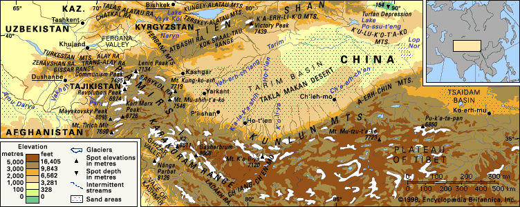
- Tien Shan: Stretching across a vast area, this system is characterized by high alpine ridges, deep basins, and significant glacial development. It features extreme elevation changes, including the Turfan Depression, the lowest point in Central Asia.1213
- Kunlun Mountains: Extending roughly 1,250 miles from the Pamirs eastward into China, these mountains form a massive rampart that separates the Plateau of Tibet from the Tarim Basin.14
- Karakoram Range: Located at the center of Asia, this range contains one of the world’s highest concentrations of mountains and some of the longest glaciers outside of the polar regions. It acts as a critical watershed between Central and South Asia.15
- Hindu Kush: This system runs northeast to southwest, serving as a major watershed that divides the Amu Darya valley from the Indus River valley. Historically, its high passes have been of immense military and cultural significance.16
- Altai Mountains: Situated where the borders of Russia, Mongolia, and China meet, the Altai system includes the Mongolian and Gobi Altai, which dominate the southern portions of Mongolia.17
Sources
- Turkistan Range — Encyclopædia Britannica
- Pamirs - Physiography — Encyclopædia Britannica
- Pamirs — Encyclopædia Britannica
- Zeravshan Range — Encyclopædia Britannica
- Highland climate — Encyclopædia Britannica
- Atmosphere - Mountain barriers — Encyclopædia Britannica
- Microclimate — Encyclopædia Britannica
- Rain shadow — Encyclopædia Britannica
- rain shadow — Merriam-Webster
- Orographic precipitation — Encyclopædia Britannica
- Sierra Madre - Climate — Encyclopædia Britannica
- Kunlun Mountains — Encyclopædia Britannica
- Tien Shan - Geology of Tien Shan — Encyclopædia Britannica
- Altai Mountains - Physiography — Encyclopædia Britannica
- Karakoram Range — Encyclopædia Britannica
- Hindu Kush — Encyclopædia Britannica
- Tien Shan - Physiography — Encyclopædia Britannica
- Asia - The influence of topography — Encyclopædia Britannica
- history of Central Asia: Top Questions — Encyclopædia Britannica
Published on · 3 min read