Deep-sea Trench
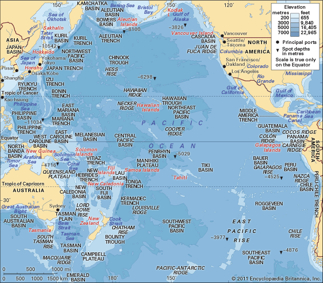
The deepest known trench on Earth is the Mariana Trench, located in the western North Pacific Ocean.
Which is the deepest known trench in the world, and how deep is it?
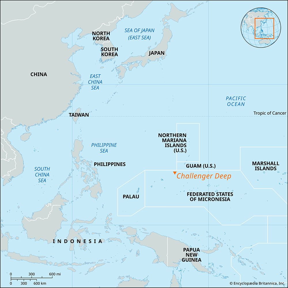
The deepest known trench on Earth is the Mariana Trench, located in the western North Pacific Ocean.12
The greatest depths within this trench are found in the Challenger Deep, a steep-walled valley on the trench floor. Measuring the exact depth of this region is technically challenging, and reports vary based on the equipment and expeditions used. While estimates often cite depths around 10,935 meters (35,876 feet), other scientific sources report the deepest point reaching approximately 11,034 meters (36,200 feet).234
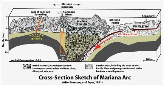
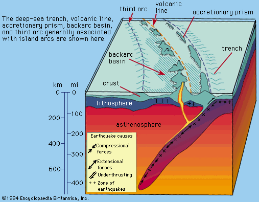
The trench was formed by the process of subduction, where the Pacific Plate is forced beneath the Philippine Plate. Because of these extreme depths, the area is subject to intense hydrostatic pressure, exceeding 1,089 standard atmospheres.32
How do scientists measure the depth and map the topography of deep-sea trenches?
Scientists employ a variety of sophisticated technologies to measure the depth and map the topography of deep-sea trenches, as the seafloor is opaque to light and difficult to access.8
Acoustic Methods
The primary tool for mapping is sonar, which uses sound pulses to determine distance. By measuring the time it takes for a pulse to travel to the seafloor and return, scientists calculate depth based on the speed of sound in seawaterspeed of sound](https://www.britannica.com/science/speed-of-sound-physics) in seawater.89
- Multibeam Echo Sounders: Systems like Seabeam provide continuous records of seafloor topography by emitting multiple acoustic pulses.89
- Side-Scanning Sonar: High-frequency pulses are used to measure the texture of the seafloor.8
- Near-Bottom Systems: Instruments like the “Deep Tow” are towed close to the seafloor to produce highly detailed images of fine-scale features that surface-based systems might miss.8
Satellite Altimetry
Satellites equipped with radar altimeters map the ocean surface, which is warped by the gravitational pull of seafloor features. Because deep-sea trenches cause the ocean surface to “downwarp,” these measurements allow scientists to compute gravity maps that reveal previously uncharted trenches and ridges.810
Direct Exploration
For precise, localized data, researchers use:
- Submersibles and AUVs: Manned submersibles and autonomous underwater vehicles (AUVs) can carry sensors directly into the trenches.1112
- Drilling Ships: Vessels like the JOIDES Resolution can collect physical samples from the seafloor, providing critical data on the composition of these deep basins.12
How do tectonic plate movements contribute to the formation of deep-sea trenches?
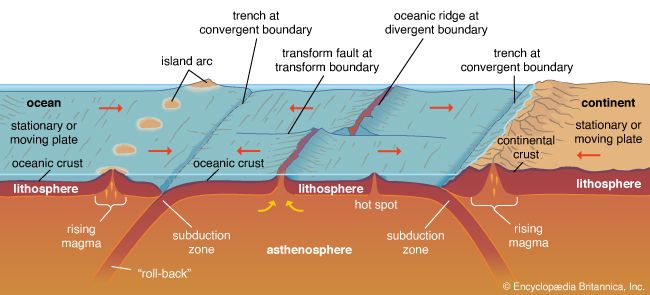
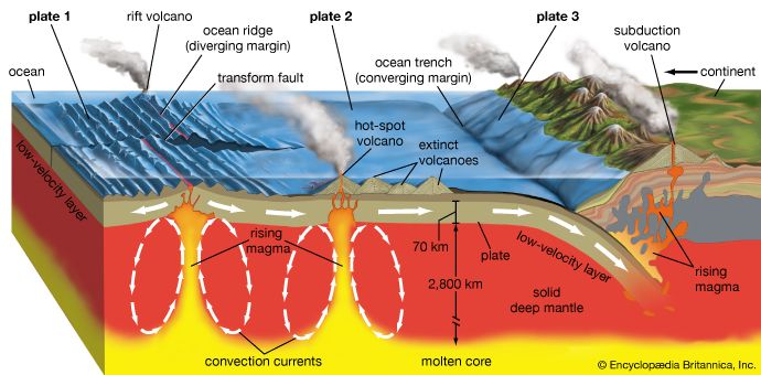
Deep-sea trenches are primarily formed through the process of plate tectonics, specifically at convergent plate boundaries known as subduction zones.1415
The Subduction Process
At these boundaries, two lithospheric plates converge. When an older, denser oceanic plate meets a younger, less-dense plate or a continental mass, the denser plate is forced downward into the Earth’s mantle. This descent creates a deep, V-shaped depression on the seafloor, which we identify as a trench.14151617
Key Mechanisms
- Frictional Drag: As the descending plate bends and slides into the mantle, frictional drag between the two plates contributes to the formation of the trench’s characteristic depth.18
- Seismic Activity: The movement is marked by the Wadati-Benioff zone, a planar zone of earthquakes that tracks the path of the subducting slab as it descends into the asthenosphere. slab as it descends into the asthenosphere.1618
- Accretionary Wedges: As the plate descends, the overriding plate often scrapes sediments and crustal material off the subducting slab, forming an accretionary prism or wedge that can alter the trench’s topography.1817
While most trenches are formed by this subduction, it is important to note that some deep linear troughs, such as certain fracture zones or rift valleys, may be misidentified as trenches despite having different geological origins.17
How do deep-sea trenches affect marine life and ecosystems?
Deep-sea trenches, which define the hadal zone at depths exceeding 6,000 meters, present extreme environmental challenges for marine life, primarily due to intense hydrostatic pressure and the absence of sunlight in the aphotic zone.2116
Adaptations to Extreme Conditions
Because the weight of the water column creates immense pressure, organisms inhabiting these depths lack air-filled compartments like lungs or swim bladders, which would otherwise compress or collapse. While some species migrate vertically to the surface, others, such as certain fish, sea cucumbers, and brittle stars, remain in total darkness throughout their lives.1621
Chemosynthetic Ecosystems
In areas of tectonic activity within or near these trenches, hydrothermal vents support unique biological communities that are entirely independent of solar energy.2223
- Energy Source: Instead of photosynthesis, these ecosystems rely on chemosynthesis, where sulfur-oxidizing bacteria convert chemical energy from volcanic minerals into organic carbon.2218
- Symbiosis: Many vent species, such as vestimentiferan worms and bivalve clams, host these bacteria within their bodies in mutualistic symbioses, deriving nutrition directly from them.2218
- Biodiversity: These vents act as biological hotspots, hosting a high density of specialized fauna, including crabs, sea anemones, and eelpouts, with hundreds of new species identified since research began in the 1980s.2218
Sources
- Pacific Ocean: Top Questions — Encyclopædia Britannica
- Challenger Deep — Encyclopædia Britannica
- deep-sea trench — Encyclopædia Britannica
- Mariana Trench — Merriam-Webster
- Mariana Trench — Encyclopædia Britannica
- How deep is the ocean? — Encyclopædia Britannica
- Indian Ocean: Top Questions — Encyclopædia Britannica
- ocean basin - Exploration of the ocean basins — Encyclopædia Britannica
- geoid - Radar altimetry of the ocean surface — Encyclopædia Britannica
- bathymetry — Encyclopædia Britannica
- bathymetric map — Encyclopædia Britannica
- autonomous underwater vehicle — Merriam-Webster
- undersea exploration - Platforms — Encyclopædia Britannica
- ocean basin - General features — Encyclopædia Britannica
- subduction zone — Encyclopædia Britannica
- deep-sea trench - Origin of deep-sea trenches — Encyclopædia Britannica
- plate tectonics - Subduction zones — Encyclopædia Britannica
- deep-sea trench - Structure — Encyclopædia Britannica
- plate tectonics - Seafloor spreading — Encyclopædia Britannica
- plate tectonics - Discovery of ocean basin features — Encyclopædia Britannica
- community ecology - The pyramid structure of communities — Encyclopædia Britannica
- Marine ecosystem - Geography, oceanography, and topography — Encyclopædia Britannica
- deep-sea vent — Encyclopædia Britannica
- Biosphere - Hydrostatic pressure — Encyclopædia Britannica
- Marine ecosystem - Organisms of the deep-sea vents — Encyclopædia Britannica
Published on · 4 min read