Vychegda River
The Vychegda River is a 702-mile (1,130-km) long tributary of the Northern Dvina River located in northwestern Russia. It flows through the Komi Republic and…
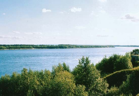
What is Vychegda River?
The Vychegda River is a 702-mile (1,130-km) long tributary of the Northern Dvina River located in northwestern Russia. It flows through the Komi Republic and the Arkhangelsk oblast (province), rising on the slopes of the Timan Ridge before joining the Northern Dvina at Kotlas.1
The river’s basin covers approximately 47,400 square miles (122,800 square km). Its course is characterized by numerous marshes, lakes, sandbanks, and cutoffs. Despite these features, the river remains navigable for 596 miles (960 km) up to the town of Voldino. Due to the region’s severe climate, the Vychegda typically freezes in early November and thaws in late April. Historically, the river and its basin served as vital routes for fur hunters and explorers traveling toward the Urals and Siberia.12
What is the Northern Dvina River system?
The Northern Dvina River is a major waterway in northern European Russia, formed by the confluence of the Sukhona and Yug rivers at Velikiy Ustyug. It flows 462 miles (744 km) northwest, emptying into the White Sea near Arkhangelsk. The river system drains a vast basin of 138,000 square miles, characterized by coniferous forests, bogs, and undulating plains.4
Key components of the system include:
- Tributaries: Major rivers feeding the system include the Vychegda River, the Sukhona, the Vaga, and the Pinega.4
- Navigation and Economy: The river is a vital transport route, linked to the Volga-Baltic Waterway. It is essential for the timber industry, with Kotlas and Arkhangelsk serving as key industrial hubs.4
- Hydrology: Primarily fed by snowmelt, the river experiences significant spring flooding and ice jams. It typically freezes in November and thaws by late April.4
What are the characteristics of the taiga biome found in the Komi Republic?
The taiga, or coniferous forest, is a defining landscape of the Komi Republic in northwestern Russia. As a major biome, it exhibits several distinct characteristics within this region:
- Vegetation: The forest is composed primarily of dense stands of cone-bearing, evergreen trees, including spruce, pine, and fir, often interspersed with deciduous species like birch. In the extreme northeast, these trees become stunted before transitioning into tundra vegetation.63
- Terrain and Soil: The landscape is marked by extensive marshes and peat bogs. The soils are generally characterized by low fertility, which limits agricultural development to small, localized areas along southern riverbanks.3
- Climate Adaptation: The region experiences a severe climate with long, cold winters and cool summers. Plants and animals in this biome are specifically adapted to these conditions and the short growing seasons.63
- Human Impact: The taiga is central to the republic’s economy, supporting significant timber and wood-processing industries. However, the environment has faced challenges from industrial activity, including large-scale oil spills in the Pechora River basin.37
How do rivers in northern Russia impact local transportation and trade?
Rivers in northern Russia have served as essential transport arteries and trade routes since early times, facilitating both historical expansion and modern industrial activity.94
Historical Significance
Historically, rivers provided the primary means of movement across the vast, often difficult terrain of the Russian Plain. Early fur hunters and colonists utilized river systems and their low, easy portages to navigate between basins, including routes that crossed the Ural Mountains into Siberia. Towns and monasteries were frequently established at strategic confluences, serving as hubs for regional trade and colonization.349
Modern Transportation and Trade
Today, these waterways remain vital to the Russian economy:
- Timber Industry: The Northern Dvina River is a primary route for rafting timber from forest-rich basins to sawmilling centers like Arkhangelsk and Kotlas.9
- Waterway Systems: Integrated networks like the Volga-Baltic Waterway and the White Sea–Baltic Canal connect northern rivers to the Baltic Sea, allowing for the movement of large vessels and significant cargo capacity.1011
- Arctic Access: Rivers such as the Pechora and the Northern Dvina provide access to northern ports, linking interior resources to the Northern Sea Route.912
Operational Challenges
The utility of these rivers is constrained by the climate. Most northern rivers are blocked by ice for 180 to 220 days a year, typically freezing in November and thawing by late April. Additionally, spring snowmelt often causes significant flooding and ice jams, which can temporarily disrupt navigation.93114
Sources
- Vychegda River — Encyclopædia Britannica
- Vychegda — Merriam-Webster
- Komi — Encyclopædia Britannica
- Northern Dvina River — Encyclopædia Britannica
- Dvina, Northern — Merriam-Webster
- Taiga — Encyclopædia Britannica
- Taiga - Effects of human use and management of the taiga — Encyclopædia Britannica
- Komi-Permyak — Encyclopædia Britannica
- Volga-Baltic Waterway — Encyclopædia Britannica
- Arkhangelsk — Encyclopædia Britannica
- Russia - Rivers — Encyclopædia Britannica
- Neva River — Encyclopædia Britannica
Published on · 3 min read