Yucatán Channel
The Yucatán Channel is a 135-mile (217 km) wide strait that serves as a vital maritime connection between the Caribbean Sea and the Gulf of Mexico. It is…
What is Yucatán Channel?
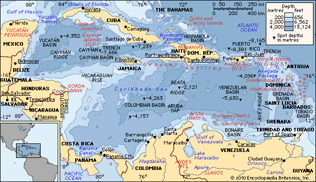
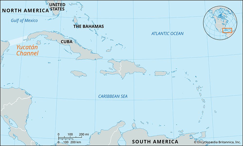
The Yucatán Channel is a 135-mile (217 km) wide strait that serves as a vital maritime connection between the Caribbean Sea and the Gulf of Mexico. It is situated between Cape Catoche, Mexico, and Cape San Antonio, Cuba.1
Hydrologically, the channel plays a critical role in regional oceanography. Driven by trade winds, surface waters from the Caribbean are forced through this narrow passage into the Gulf of Mexico. This accumulation of water creates a hydrostatic head—a difference in sea level—that is considered the primary driving force behind the Gulf Stream. While the majority of the water flowing through the channel is surface water, a portion consists of deeper Subantarctic intermediate water.2
How does the Gulf Stream affect global climate?
The Gulf Stream plays a significant role in regulating global climate by acting as a major mechanism for the poleward transfer of heat from the tropics to colder regions.34
Climate Moderation
The most notable impact of the Gulf Stream is its warming effect on northwestern Europe. As the current flows northeastward and emerges as the North Atlantic Current, it carries vast amounts of heat and moisture. Prevailing westerly winds transport this warmth over the continent, resulting in significantly milder winters than would otherwise be expected at such high latitudes. For example, coastal areas in Norway experience winter temperatures more than 40 °F (22 °C) warmer than the global average for their latitude.45
Atmospheric and Regional Effects
- Temperature Anomalies: The current creates one of the world’s greatest temperature anomalies, allowing for the growth of subtropical vegetation in regions like southwestern England.5
- Fog Formation: Near the Grand Banks of Newfoundland, the contact between warm, moist air over the Gulf Stream and the cold Labrador Current leads to frequent, widespread condensation, resulting in some of the highest incidences of fog in the world.5
What are the main differences between the Caribbean Sea and the Gulf of Mexico?
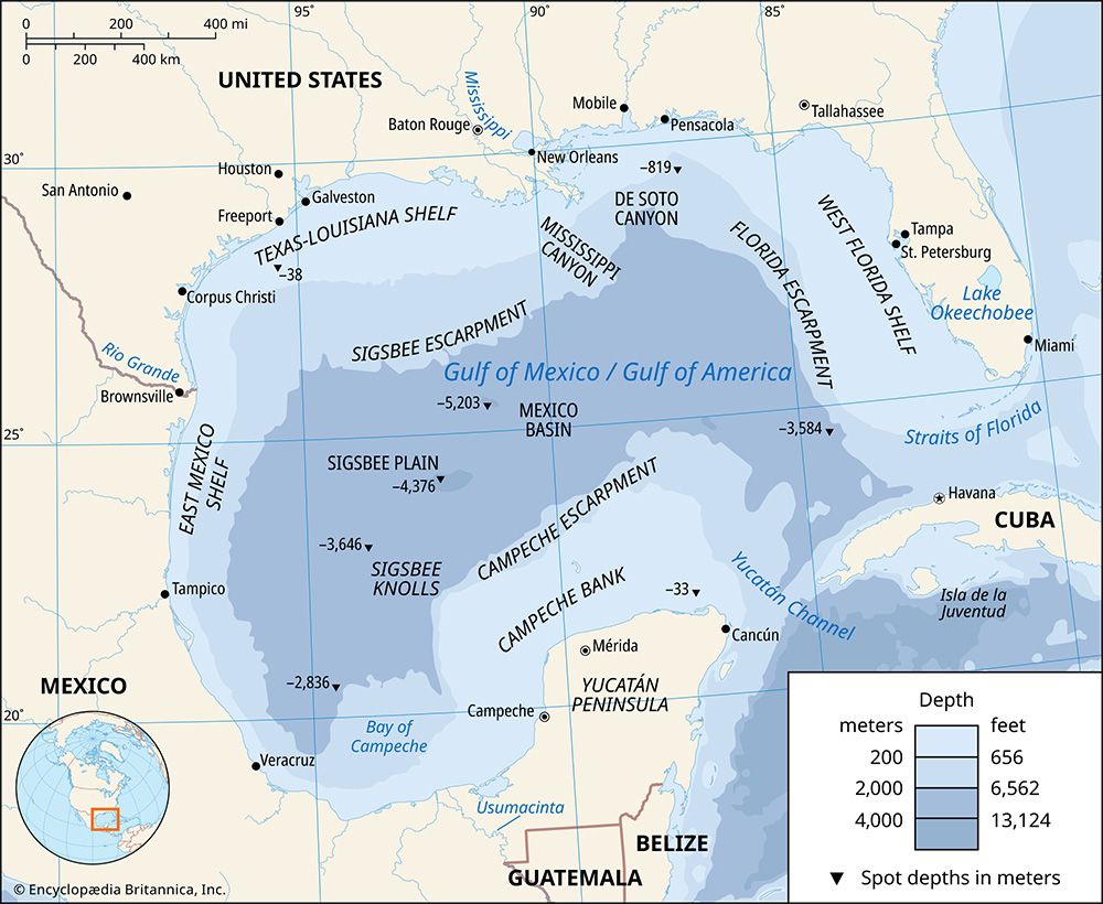
The Caribbean Sea and the Gulf of Mexico are distinct suboceanic basins that, while often grouped together as the “Central American Sea,” differ significantly in their physical and hydrological characteristics.6
Key Differences
- Geography and Boundaries: The Caribbean Sea is a vast basin bounded by the coasts of Central and South America to the west and south, and the Antilles island arcs to the north and east. In contrast, the Gulf of Mexico is a smaller basin located to the north of the Caribbean, bordered primarily by the United States, Mexico, and Cuba.67
- Hydrology and Currents: The Caribbean acts as a source for the Gulf of Mexico; surface waters are driven by trade winds from the Caribbean through the Yucatán Channel into the Gulf. This flow creates a hydrostatic head that is a primary driver of the Gulf Stream.78
- Salinity and Temperature: The Gulf of Mexico experiences wide salinity variations due to significant river drainage, such as from the Mississippi River, whereas the Caribbean maintains more stable conditions favored by coral reefs. Additionally, the Caribbean’s deep-water temperatures are warmer (approx. 39 °F/4 °C) than those of the open Atlantic due to shallow sills that block colder Antarctic bottom water.728
How do trade winds influence ocean currents?
Trade winds are a primary driver of global ocean currents, exerting stress on the sea surface that sets the upper layer of water in motion. This process is governed by several key physical principles:31011
- Wind Stress and Ekman Transport: Trade winds blow persistently toward the Equator and westward from subtropical high-pressure belts. Because of the Coriolis force, the resulting surface water movement does not follow the wind direction exactly. Instead, the water is deflected—to the right in the Northern Hemisphere and to the left in the Southern Hemisphere—in a phenomenon known as Ekman transport.12101113
- Gyre Formation: The cumulative effect of wind stress and Ekman transport across the oceans creates large, circular current systems called gyres. In the tropics, trade winds drive the westward-flowing Equatorial currents, which serve as the foundation for these massive, wind-driven circulation cells.143
- Upwelling and Downwelling: Variations in wind patterns lead to convergence and divergence zones. Where trade winds cause surface waters to diverge, upwelling occurs, drawing nutrient-rich subsurface water to the surface. Conversely, convergence zones lead to downwelling, which helps drive the circulation of water into deeper layers.1011
Sources
- Yucatán Channel — Encyclopædia Britannica
- Caribbean Sea - Hydrology — Encyclopædia Britannica
- Climate - The Gulf Stream — Encyclopædia Britannica
- How Do Ocean Currents Affect the Biosphere? — Encyclopædia Britannica
- Gulf Stream — Encyclopædia Britannica
- Caribbean Sea — Encyclopædia Britannica
- Gulf of Mexico / Gulf of America - Hydrology — Encyclopædia Britannica
- Caribbean Current — Encyclopædia Britannica
- Caribbean Sea - Resources — Encyclopædia Britannica
- ocean current - Ekman layer — Encyclopædia Britannica
- Ekman layer — Encyclopædia Britannica
- ocean current - The subtropical gyres — Encyclopædia Britannica
- ocean current - Distribution of ocean currents — Encyclopædia Britannica
- ocean current - Coriolis effect — Encyclopædia Britannica
- Coriolis force — Encyclopædia Britannica
- Trade wind — Encyclopædia Britannica
- ocean current - Wind-driven circulation — Encyclopædia Britannica
- Pacific Ocean - The trade winds — Encyclopædia Britannica
Published on · 3 min read