Fjärd
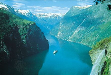
A fjärd is a rocky inlet of the sea, typically found along low-lying coastlines. These features are formed by the submergence of a glacial valley.
What is fjärd?
A fjärd is a rocky inlet of the sea, typically found along low-lying coastlines. These features are formed by the submergence of a glacial valley.1
While they share a glacial origin with fjords, fjärds are characteristically more irregularly shaped. Unlike fjords, which are known for their steep sides and deep, narrow channels, fjärds are often connected by complex mazes of channels and are not typically classified as river-fed estuaries. Like fjords, however, they may be quite deep and can feature thresholds at their mouths.1
How do glaciers shape the landscape to create inlets?
Glaciers shape the landscape to create inlets primarily through the process of glacial erosion, which carves deep, distinct valleys into the Earth’s crust.56
As massive, heavy glaciers move through mountainous or coastal terrain, they erode the underlying rock through two main methods:
- Abrasion: The grinding of surface materials by debris embedded in the base of the ice.6
- Quarrying (Plucking): The removal of large blocks of rock from the glacier bed.6
This intense erosive power creates characteristic U-shaped valleys that are often deepest in their middle and upper reaches, where the ice movement is most vigorous. During periods of lower sea levels, such as the Pleistocene Epoch, these valleys were excavated far below the current sea level.51
When the climate warmed and the glaciers melted, the rising sea level inundated these deep, steep-sided valleys, forming fjords or, in the case of lower-lying, more irregular coastal terrain, fjärds. These inlets often feature a submerged ridge or threshold at their mouth, composed of glacial deposits left behind as the ice retreated.5417
What is the difference between a fjärd and a lagoon?
A fjärd and a lagoon are both coastal features, but they differ significantly in their origins and physical characteristics.
- Origin: A fjärd is a rocky inlet formed by the submergence of a glacial valley as sea levels rose. In contrast, a lagoon is typically formed by the development of a barrier island or spit—often made of sand or shingle—that encloses a body of water behind it.1105
- Structure: Fjärds are characterized by irregular, rocky shapes and deep channels, sometimes featuring thresholds at their mouths. Lagoons are generally quieter, shallower environments where fine sediments like clay and mud accumulate, often influenced by river loads and continuous deposition.110
- Dynamics: While fjärds are not typically river-fed estuaries, lagoons are often shaped by wave action, tides, and the continuous transport of sediment from inland areas.1105
What are some other coastal features formed by glaciation?
Glaciation significantly alters coastal landscapes through both erosional and depositional processes. Beyond fjords and fjärds, several other coastal features are formed or modified by the movement and retreat of glaciers:
- Glacial Troughs: These are large, deep, U-shaped valleys carved by ice streams. When these troughs extend onto the continental shelf and are submerged, they form massive submarine features like the Laurentian Trough. These are often found near the margins of large modern or former ice sheets.1251
- Hanging Valleys: As main glaciers erode deep troughs, smaller tributary glaciers carve shallower valleys that remain high above the main valley floor. Once the ice retreats, these often result in dramatic waterfalls where streams plunge from the hanging valley into the main coastal inlet or sea.138
- Glacial-Marine Deltas: As glaciers melt, they deposit significant amounts of sediment into the sea. These deposits form deltas at the mouths of glacial streams. These features are critical for identifying postglacial sea-level changes, as they often record the elevation of the land relative to the sea at the time of deposition.5
- Moraine-Framed Shorelines: Glacial debris, or till, deposited at the margins of ice sheets can form extensive ridges known as moraines. These ridges can act as the foundation for coastal features; for example, the terminal moraines of the Laurentide Ice Sheet helped frame the geography of Long Island, which was later reworked by coastal processes into barrier islands.145
Sources
- fjärd — Encyclopædia Britannica
- list of fjords — Encyclopædia Britannica
- Baltic Sea - Coastal features — Encyclopædia Britannica
- estuary - Fjords — Encyclopædia Britannica
- fjord — Encyclopædia Britannica
- erosion — Encyclopædia Britannica
- coast — Encyclopædia Britannica
- coastal landforms - Landforms of erosional coasts — Encyclopædia Britannica
- fjord — Merriam-Webster
- lagoon - Barrier bars and sediment sources — Encyclopædia Britannica
- lagoon - Waves , tides, and surf — Encyclopædia Britannica
- glacial landform - Erosional landforms of continental glaciers — Encyclopædia Britannica
- moraine — Encyclopædia Britannica
- Quaternary - Landforms — Encyclopædia Britannica
- glacial landform - Moraines — Encyclopædia Britannica
- Laurentian Trough — Encyclopædia Britannica
- glacial valley — Encyclopædia Britannica
Published on · 3 min read