Strait of Belle Isle
The Strait of Belle Isle is a channel located in eastern Canada that serves as the northern entrance from the Atlantic Ocean to the Gulf of St. Lawrence.
What is Strait of Belle Isle?
The Strait of Belle Isle is a channel located in eastern Canada that serves as the northern entrance from the Atlantic Ocean to the Gulf of St. Lawrence.12
Spanning approximately 90 miles (145 km) in length and ranging from 10 to 17 miles in width, the strait lies between the northern tip of Newfoundland and the coast of Labrador. It functions as the most direct maritime route for vessels traveling from the Great Lakes and the St. Lawrence Seaway to Europe.12
Navigation through the area is significantly influenced by the cold Labrador Current, which causes extended periods of ice cover. Consequently, the shipping season is typically restricted to the months between June and late November.1
What is the Labrador Current and how does it affect the climate?
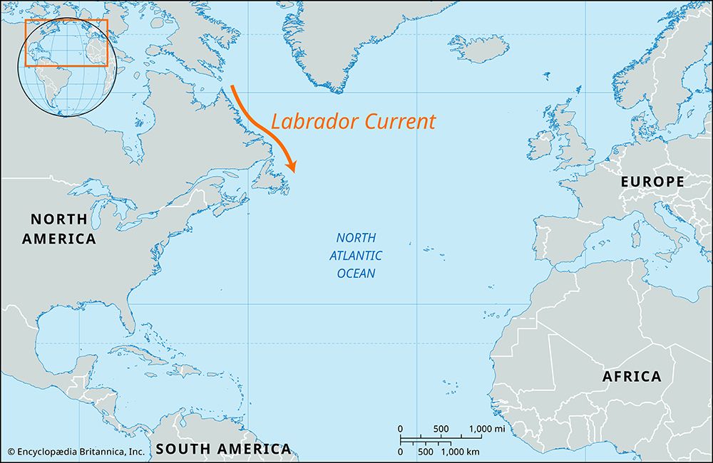
The Labrador Current is a cold, low-salinity surface oceanic current that flows southward along the western side of the Labrador Sea. It is formed by the convergence of the West Greenland Current, the Baffin Island Current, and inflow from the Hudson Strait. The current maintains temperatures below 32° F (0° C) and annually transports thousands of icebergs southward.34
Regarding its climatic impact, the Labrador Current plays a significant role in regional weather patterns, particularly when it interacts with the warm Gulf Stream. Near the Grand Banks of Newfoundland, the contact between cold, humid air moving over the Labrador Current and the warm surface waters of the Gulf Stream triggers widespread condensation. This interaction results in one of the highest incidences of fog in the world. Additionally, because the current carries cold water along the North American coast, it contributes to the harsh winter temperatures experienced in regions like Nova Scotia, where the prevailing winds are predominantly from the shore.5
How does the St. Lawrence Seaway connect to the Great Lakes?
The St. Lawrence Seaway connects the Great Lakes to the Atlantic Ocean through a massive system of canals, locks, and river improvements. Completed in 1959, the project allows deep-draft ocean vessels to travel as far inland as Duluth, Minnesota.67
The connection is achieved through several key engineering components:
- St. Lawrence River: The official seaway includes a 299-km (186-mile) stretch of the river between Montreal and Lake Ontario. This section utilizes a series of locks and canals to bypass rapids and overcome a 69-metre (226-foot) drop in elevation.68
- Welland Canal: This vital link connects Lake Ontario and Lake Erie, allowing ships to bypass the Niagara River and Niagara Falls.68
- Connecting Channels: To ensure deep-draft navigation throughout the entire system, the U.S. Army Corps of Engineers deepened various channels, including the Straits of Mackinac, the St. Marys River, and the Detroit River.8
What are the challenges of navigating through ice-covered waters?
Navigating through ice-covered waters presents significant hazards to maritime safety and structural integrity. The primary challenges include:
- Collision Hazards: Icebergs are major threats, particularly in the North Atlantic and the Southern Ocean. Decaying icebergs often shed “growlers” and “bergy bits”—smaller, dense pieces of ice that are difficult to detect via radar due to their low cross-section, yet possess enough mass to severely damage or sink a vessel.910
- Structural Stress: Ships operating in polar regions face extreme mechanical loads. Icebreakers must be specifically designed to withstand the shock of ramming thick sea ice and the intense pressure exerted by pack ice squeezing the hull.11
- Environmental Conditions: Severe winter storms can cause sea spray to freeze onto a ship’s superstructure, adding dangerous weight that affects stability. Additionally, navigation is often complicated by poor visibility caused by fog, rain, and powerful tidal currents.1211
- Detection Limitations: While synthetic aperture radar and satellite imagery have improved tracking, ice remains difficult to discriminate from sea foam and whitecaps in rough conditions.910
Sources
- Strait of Belle Isle — Encyclopædia Britannica
- Belle Isle, Strait of — Merriam-Webster
- Labrador Current — Encyclopædia Britannica
- Gulf Stream — Encyclopædia Britannica
- Labrador Sea — Encyclopædia Britannica
- St. Lawrence Seaway — Encyclopædia Britannica
- St. Lawrence Seaway - Construction of the seaway — Encyclopædia Britannica
- St. Lawrence River — Encyclopædia Britannica
- iceberg - Iceberg detection, tracking, and management — Encyclopædia Britannica
- Bering Sea and Strait - Navigation — Encyclopædia Britannica
- sea ice - The emerging impacts of recent changes to sea ice — Encyclopædia Britannica
- International Ice Patrol — Encyclopædia Britannica
- Arctic - The Arctic Ocean — Encyclopædia Britannica
- naval architecture - Hydrostatic and hydrodynamic loads in service — Encyclopædia Britannica
Published on · 3 min read