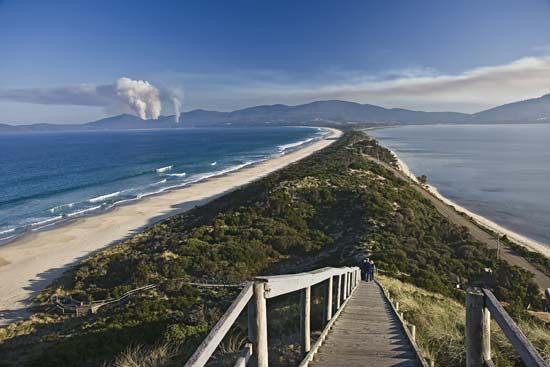
Land Bridge
A land bridge is an isthmus or strip of land that periodically connects major landmasses, such as continents or a continent and an island. These connections…
What is land bridge?
A land bridge is an isthmus or strip of land that periodically connects major landmasses, such as continents or a continent and an island. These connections have historically allowed for the migration of plants and animals, enabling species to extend their ranges into new territories.12
The formation of land bridges is often associated with periods of worldwide glaciation, which lower sea levels and expose former seafloors. A prominent example is Beringia, a vast region that intermittently linked Siberia and Alaska during the Pleistocene Epoch. This route is widely considered a primary path by which humans migrated into and populated the Americas. Another significant example is the Isthmus of Panama, which, when elevated, allowed for the exchange of fauna between North and South America.31
In a modern commercial context, the term “landbridge” can also refer to an overland route, such as a railway, used to transport cargo across a country between two ports.2
How do ice ages cause sea levels to drop?
Ice ages cause global sea levels to drop primarily through the net transfer of water from the oceans to the continents. During glacial periods, cooler temperatures lead to the accumulation of massive ice sheets and glaciers on land. Because this ice originates from water that evaporates from the ocean, the growth of these ice masses effectively sequesters vast quantities of water on land, preventing it from returning to the sea.45678
This process is a direct result of the Earth’s hydrological cycle. As water evaporates from the ocean, it falls as precipitation—often as snow—which then compacts and recrystallizes into ice. During the peak of the most recent glacial stage approximately 18,000 years ago, this sequestration was so significant that global sea levels were roughly 120 to 130 metres (about 390 to 426 feet) lower than they are today. Consequently, this drop in sea level exposed large areas of the continental shelves, creating land bridges that connected previously separated landmasses.6487
What is the Great American Biotic Interchange?
The Great American Biotic Interchange refers to the significant faunal migration event that occurred approximately 3 million years ago, when the formation of the Isthmus of Panama created a land bridge connecting North and South America.9
Prior to this event, South America had been isolated for millions of years, allowing its fauna—notably marsupial mammals—to evolve in relative seclusion. The emergence of the isthmus ended this isolation, triggering a massive exchange of species between the two continents.91
The interchange had profound ecological consequences:
- North-to-South Migration: Numerous placental mammals and carnivores moved southward. These northern invaders were highly adaptable and successful in competing for resources, which contributed to the extinction of at least four orders of native South American land mammals.9
- South-to-North Migration: A smaller number of species, such as the armadillo and the opossum, successfully migrated northward.91
- Long-term Impact: Some species that migrated south, such as the llama and tapir, eventually went extinct in their northern regions of origin, finding their last refuges in South America.9
How do scientists study land bridges that are now underwater?
Scientists study submerged land bridges and ancient coastal environments by employing a variety of sophisticated geophysical and geological techniques to map the seafloor and analyze its composition. Because electromagnetic radiation cannot penetrate deep water, researchers rely on the following methods:
- Acoustic and Seismic Techniques: Scientists use echo sounding and multi-frequency systems like Seabeam and GLORIA to map the morphology of the seafloor in two-dimensional swaths. Seismic reflection techniques, which utilize sound waves triggered by controlled blasts, allow researchers to measure the structure of the Earth’s crust deep beneath the seafloor sediments.1314
- Sampling and Coring: To understand the physical and chemical history of these areas, researchers collect samples using dredges and coring devices. Hydraulic piston corers can extract undisturbed sediment cores up to 200 metres long, providing a historical record of past climates and environments.13
- Satellite Mapping: Because the shape of the sea surface is influenced by the gravity of the seafloor, satellite measurements of surface topography help provide a global view of the ocean bottom and identify features like seamounts.13
- Tectonic Uplift Analysis: In regions where the land has undergone tectonic uplift, ancient shorelines and their deposits are exposed above modern sea level. By studying these areas, such as those in New Guinea or Barbados, scientists can relate these records to global glaciation and sea-level history.15
Sources
- land bridge — Encyclopædia Britannica
- Beringia — Encyclopædia Britannica
- land bridge — Merriam-Webster
- Quaternary - Sea-level changes — Encyclopædia Britannica
- ice formation — Encyclopædia Britannica
- paleogeography - Agents of paleogeographic change — Encyclopædia Britannica
- sea level — Encyclopædia Britannica
- Climate change - Glacial and interglacial cycles of the Pleistocene — Encyclopædia Britannica
- Columbian Exchange - Animals — Encyclopædia Britannica
- plate tectonics - Evolution — Encyclopædia Britannica
- Isthmus of Panama — Encyclopædia Britannica
- South America - Animal life — Encyclopædia Britannica
- paleogeology — Encyclopædia Britannica
- undersea exploration - Exploration of the seafloor and the Earth’s crust — Encyclopædia Britannica
- surveying - Hydrography — Encyclopædia Britannica
- ocean basin - Sedimentation patterns — Encyclopædia Britannica
- Pleistocene Epoch - Coastal environments and sea-level changes — Encyclopædia Britannica
Published on · 3 min read